|
|
 |
 |
 |
 |
|
Des Newman's OziExplorerCE for the Pocket PC |
20th August 2002
|
|
Reviewed by Mike Barrett |
|
|
OziExplorer
is somewhat different to the other GPS Mapping software packages
reviewed here: Firstly it is shareware and not maintained by any
commercial concern. Secondly it does not come with any maps. Thirdly
it uses a different mapping technology compared to other products. |
 |
|
OziExplorer
is targeted at a different type of user: the professional and recreational
off-road user.
This software is useful for and used world-wide by
emergency services, law enforcement, forestry,
geological and mining, palaeontologists, archaeologists, local
council/boroughs, hikers, bikers, off-roaders, sailors, and
pilots, plus many more. This is not software you can buy off the
shelf and start using (OziCE maps need to be converted using
OziExplorer). You have to acquire pre-calibrated maps or create and calibrate your
own maps, this is not as daunting as it first appears, all you need
is a scanner and some paper maps. The software is so flexible that
you could even use satellite images or aerial photographs as provided on
many mapping websites (Please check copyright clauses before
downloading images)
The
software comes in two downloadable packages: OziExplorerCE for your
Pocket PC computer at $25, and OziExplorer for your PC or Laptop
priced at $75 (optional). There are demo versions of each package
available to download from the OziExplorer web site at www.oziexplorer.com.
There is also a trial version of the PC software with more features
enabled.
There
are a wealth of features packed into the software the main areas
being:
-
Display
of commercial and user created maps.
-
Live
display of current position using GPS interface
-
Display
and logging of track
-
Creation
and display of waypoints (positions on your map)
-
Display
of route
-
Navigation
instructions based on route
For
the purposes of this review an iPaq 3870 was used with a NavMan
3000 GPS sleeve. This review focuses on the OziExplorerCE
software, another review covers the OziExplorer (PC) software. |
|
Software Installation
Installation is a simple matter of downloading the software
package in the format and configuration to suit you. then running
the setup application. OziExplorerCE is available for Handheld PC,
Palm PC and Pocket PC, in either self extracting zip, or normal
zip formats. The same process applies for the PC version of OziExplorer.
To create maps for OziExplorerCE you will also need to download
the Img2ozf utility.
The software can be
registered using links on the OziExplorer web site. This sends you
to the ShareIt shareware registration site where you can provide
your credit card details and pay for the registration key. The turnaround
time between placing the order and receiving the registration key
was extremely fast.
To use OziExplorerCE
and prepare maps for it you only need to register OziExplorerCE
and use the OziExplorer Trial Version to create your maps. There
are a few restrictions imposed but they do not affect the operation
of the CE software. If you find the PC Trial Version useful then
you can register that as well.
|
|
Creating a
map
Creating a map is as simple as getting a digital map image (once
you have permission), calibrating
it, converting it and loading into your Pocket PC. Unlike the other
mapping software reviewed here OziExplorer uses raster graphics
(pictures as opposed to line drawings) for it's data, thus allowing
flexibility at the expense of size. A map is the combination of
a graphical map image and a calibration file.
It sounds quite complicated
but with a little practice you can generate any maps you want quickly
and accurately. I generated the maps used for the review in less
than 15 minutes. This is done by scanning them into the
computer, trimming them using a graphics package, then using OziExplorer
(PC) to create a .map file.
The OziExplorer (PC)
software has a wealth of options for calibration. This allows me to position
the calibration marks in the corners of the scanned map on grid
line intersections and get a very accurate calibration using standard
grid references. Once this has been done for three or four points
clicking save calibrates the map and saves a map file. You can then
check the accuracy of the calibration by moving the cursor around
the map.
As a graphics image
of a map can be very large OziExplorer has a utility program to
provide a compressed file at different resolutions for the Pocket PC.
This takes the map image and then shrinks the file. As an example
one map image can be 30Mb covering an area of 25 square kilometres.
This can be reduced to 7Mb with zooms of 75%, 50%, 25% and 10%.
The map calibration
file and the converted graphical map are than transferred to the
Pocket PC OziExplorer/maps directory and you are ready to go.
|
|
Using
the software
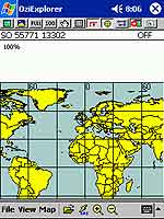
When you first start OziExplorerCE you will see an 'index' map of
the world. This is the default shown when there is not a more detailed
map to be displayed at the cursor position.
When you switch the
GPS tracking on by clicking the lightening symbol on the button
bar you will be shown the most detailed map available at that position.
If you do not have a map loaded then the World map will show your
position.
The layout of the display
provides a button bar at the top of the screen, followed by the
information bar. In the centre of the display is the map image,
and at the bottom is the menu bar.
The information bar
contains the position of the cursor, in this case it is showing
the OS grid reference, an the GPS status, currently off.
The menu bar provides
the main configuration and control of the software.
|
 |
|
Reproduced
from Ordnance Survey 1: 50,000 mapping © Crown copyright. All rights
reserved. |
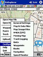
Configuration
The file menu
is where all the configuration of the software is done. As can be
seen there are a large number of options that can be set. For displaying
the OS grid reference select General Settings then BNG
for the position format.
You can determine the
size, colour and style of your cursor. I selected both an arrow
and a circle, when the arrow is selected it displays the direction
of travel.
The track logging options
allow you to specify how the track points are collected and displayed.
There is intelligence built in to the software to detect major variations
in your course and log a track point.
The units options allow
you to specify speed, distance and altitude display as either metric
or imperial.
There is also a speed
monitor which will alert you if exceed preset upper and lower limits.
|
| In
Use
The system is simple to use once set up. All you have to do
is to ensure that the map(s) covering the area(s) you are
traveling to are loaded into the PocketPC and off you go.
As soon as you get a satellite fix OziExplorerCE will display
the most detailed map at your current position.
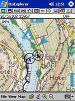
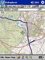
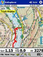
The two screen images show
the maps displayed at different zoom levels. The shot on the
left is a walking track of the passenger ferry at Symonds
Yat in the UK the second is a driving track from the campsite
at Bracelands to Coleford, with a stop off at a petrol station.
The accuracy of the GPS location
was within a few meters. At worst the car was shown to be
on the wrong side of the road. |
|
Click
on the pictures for full size images |
|
|
|
|
Reproduced
from Ordnance Survey 1: 50,000 mapping © Crown copyright.
All rights reserved. |
|
One of the more useful features of the software is the searching
for maps. When you move off the edge of your current map the
software will automatically detect this and then find and
display another map covering your current location. If none
are found then the world view is displayed.
|
|
Waypoints
At significant points on your journey you can set a waypoint simply
by tapping at the cursor. This will create a waypoint with the name
wp0 or similar. Unfortunately there is no way to rename these in
the software ( you can edit the waypoint file in notepad). In the
above picture of Symonds Yat I have set waypoints at either end
of the ferry crossing. These waypoints conform to international
standards and can be loaded into any software or hand held GPS devices
to locate features.
There are options to
load and save the waypoints, enabling you to create waypoints for
specific purposes ie Mountain Summits, positions of fishing lakes,
etc.
|
|
Tracks
Tracks are essentially a sequence of waypoints that are automatically
recorded to a file, and displayed on the screen in the screen
shots above the tracks are shown in dark blue.
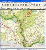
Tracks can be
saved and used either in OziExplorerCE or displayed in OziExplorer
(PC) as shown to the right. The track replay reads the track
file and simulates a GPS output thus retracing your steps.
The example on the far right shows a track from a Waterfall
Walk in the Brecon Becons in Wales loaded into OziExplorer
(PC).
You may notice
that occasionally the red track seems to be very erratic,
this is due to the information being provided by the NavMan
sleeve. This is particularly apparent in the Wales track,
the cause for this is most probably signal reception in a
ravine with leafy coverage overhead. |
Click
on images for larger picture
|
|
|
Reproduced
from Ordnance Survey 1: 50,000 mapping © Crown
copyright. All rights reserved. |
|
|
|
Click image for full size picture
Reproduced
from Ordnance Survey 1: 50,000 mapping © Crown
copyright. All rights reserved.
|
Routes
and Navigation
Routes are a series of waypoints linked together. There can
be a number of routes in a single route file. Route files
created in OziExplorer (PC) are compatible with OziExplorerCE.
At the waypoints in the route
you can create a 'proximity zone' this can be used for a number
of things though primarily for navigation instructions. This
could be used to warn of sharp drops ie exclusion areas, or
shallows around coastal regions.
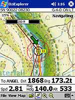
The picture on the left shows
a route down through the riverside path, note that the navigation
is set to the end of the route, due to lack of route waypoints
the route is displayed as a direct line to the next waypoint
(straight over the river and an impassable cliff.
The image on the right shows
the navigation to the waypoint named Angel. The instructions
show a sharp left turn and we are within 120 yards of the
target. |
Click image for full size picture 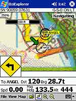
Reproduced
from Ordnance Survey 1: 50,000 mapping © Crown
copyright. All rights reserved. |
|
Strengths and
Weaknesses
When taking into account the intended use of OziExplorer it is a
perfect package for hiking, mountaineering, sailing, Mountain biking
and other outdoor pursuits, given proper protection it could even
be used for canoeing and white water rafting. It should be stressed
that this is not a substitute for mundane navigation methods and
outdoor skills, but should be used to augment them.
I once successfully
navigated across a field of 4 foot high grass following my OziExplorer
readout and arrived within 10 feet of the style marked on the map.
This software is extremely
flexible allowing a large number of configuration options and features.
On the face of it, it could look daunting and have a high learning
curve, but experience has found that once the problem of correctly
calibrating maps has been resolved then it is easy and rewarding
to use.
There are no end of
applications to the data produced from both OziExplorerCE and OziExplorer,
which can be shared throughout the GPS community.
As seen above there
are occasions when GPS will not function either correctly or at
all. A good example is under the overhang of a waterfall or in a
ravine. In these cases no signal is preferable to an incorrect reading.
The signal can be affected by a number of factors including cloud
cover, trees, buildings, cliffs, ravines, etc
An issue with OziExplorer
is obtaining or creating maps. In the USA the government makes
digital mapping data freely available. In the UK and other countries
this information is sold at commercial rates, there is no
recreational source of digital raster maps in the UK for OziExplorer
that we are aware or have tested.
The most major problem
with this package is not the software or the GPS sleeve, but the
actual battery life. Using the iPaq with most systems disabled and
lowest screen backlight the battery lasts for about 2 hours.
For $25 or approximately
£16 you get a lot of software for your money. I have been
using it for over 4 months and look forward to exploring new regions
whenever possible. This is not a system for driving
and automatic routing, but is defiantly a viable and exciting enhancement
to outdoor pursuits.
|
|
Digital Scanning of Maps and
Downloading of Digital Maps Disclaimer
All maps do hold a copyright notice to prohibit the copying of the maps.
Please check the terms and conditions of the copyright and your rights
before digitally scanning any paper maps or downloading of any digital
maps from websites. Most mapping companies
will grant you a license to make at least one copy of the map for
personal use only, however please check first and if requested to do so,
request permission from the copyright holder first before scanning or
downloading the digital maps.
Ordnance Survey Copyright Restrictions
Permission to scan an Ordnance Survey paper map (which is less than 50
years old) for retention on a retrieval system must be requested in
writing stating the purpose of scanning Ordnance Survey maps, scale of
mapping to be used and total area to be scanned in cm squared at
original scale. Permission will not be given if the customer can be
supplied with an equivalent digital mapping product from Ordnance
Survey. A one off data royalty charge will also be applied,
calculated using the number of mapping units scanned, and the customer
must hold a Digital Licence with Ordnance Survey. |
|
|
 |
 |
 |
 |
|
|