|
|
 |
 |
 |
 |
|
Anquet Maps GPS mapping software review |
02nd June 2003 |
|
 Anquet Technology Ltd. is a British software development house specialising in mapping software for the leisure market. Anquet have provided us with a copy of their GPS compatible Great Britain North and Superscale Lake District products for review. Anquet Technology Ltd. is a British software development house specialising in mapping software for the leisure market. Anquet have provided us with a copy of their GPS compatible Great Britain North and Superscale Lake District products for review.
Anquet provide UK digital topographical mapping products based on digital maps from the Ordnance Survey and Harvey Maps. These products are GPS compatible, which means that you can download and upload data between Garmin and Magellan handheld GPS receivers, but not PDAs.
This review was created using Anquet Maps, a Toshiba Tecra 8000, a Garmin Geko 201.
|

|
The Ordnance Survey products split the United Kingdom into two sections North and South and are at 1:50,000 scale, the equivalent of the Landranger Maps. These retail for £120.00 including Tax and Postage. The Great Britain North maps are reviewed here.
|
 |
Harvey Maps are not quite so well known as Ordnance Survey. They publish paper maps specifically for walking, hiking, rambling and cycling. The paper map coverage includes all the mountainous regions of the UK.
The Harvey maps are the only digital source of 1:25,000 scale maps for the UK. These are available for limited areas, popular with fell walkers and hikers: The Lake District priced at £45.00; and the Scottish highlands priced at £120.00. |
|
What do you get?
Both of the review software bundles come with the Anquet Maps application, GB Overview Map,GB Road Atlas 1:250,000 scale,
Searchable Gazetteer of over 250,000 items, and
Full GB height data (DEM), as well as your selected mapping products. Also included is a small User Guide with sufficient detail to get you started.
In the case of the Harvey Map products the data is supplied on one CD, for the Ordnance Survey data is presented on 4 CDs.
So all in all you actually get a lot of bonus material as well. |
|
The Anquet Map application
What is Anquet Maps?
In simple terms it is an application for the PC which presents seamless digital maps and allows you view, scroll, and print at different scales and sizes. But its functionality does not end there. You can set waypoints (or marks), plan routes, and interchange this data with a Garmin or Magellan GPS. Other features offer spot heights throughout the map giving you an elevation profile of your selected route.
The Anquet Map application has a master disk with the installation program which is simple to install and set up. There is a license key required which is stuck on the inside of the CD case. The only thing to watch out for is to ensure that you have the latest version of the software. Upgrades are available from the Anquet website at www.anquet.co.uk
Once installed and licensed you are ready to go.
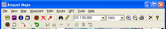
The Anquet Maps user interface has all the tools you need available on two stacked toolbars. Some of the functions are not always intuitive to the buttons, but after you get used to them they sort of make sense. Moving from top to bottom, left to right you have:
 |
Display notes/ instructions window. Each object (path, waypoint etc can have some free text associated with it. This window allows you to view and edit that text.
|
 |
Display elevation profile window. The maps provided also have height data incorporated. When you create a path the application knows what elevation various points are along the route and can draw a height profile.
|
 |
Display information window. The information window when open displays data about the selected object. For instance a waypoint displays the location and height, whereas a path will display start, end, length, height etc.
|
 |
Display Quicklist. The quicklist is like an index of saved waypoints. When you click on an entry in the quicklist the main map window displays the waypoint in the centre of the screen.
|
 |
Hide Waypoints. This button hides all the waypoints on the map.
|
 |
Hide Paths. This button hides and displays all the paths on the map.
|
 |
Size Waypoints. Waypoints can be displayed as either small or large icons. This option toggles between the two sizes.
|
 |
Find placename in the gazetteer. The gazetteer. contains details of 250,000 locations, including towns, villages, and mountains. This button displays the search window allowing you to search for a place using a partial name.
|
 |
Goto map grid reference. The goto button allows you to find and display a location based on a grid reference specified either in OSGB reference, National Grid, or Lat/Lon co-ordinates.
|
 |
Select the map source. When you use your maps Anquet tracks the data you have for a current location. This drop down box allows you to select which scale you want to display the maps at.
|
 |
Zoom the current map. This option takes the currently displayed map and show them at different sizes.
|
 |
Add new waypoint. This button changes the cursor to a cross-hair and allows you to position it. When you next click the mouse a new waypoint is created.
|
 |
Add to the quick-list. When you add an waypoint to the quick-list you will be prompted to name it prior to saving it in the list.
|
 |
Start new path. When you click on this button the application changes into path creation mode. The first mouse click will create a waypoint, subsequent mouse clicks will add new nodes to the path.
|
 |
End path. When you have finished adding legs to the path click on the end path button. The next mouse click will create a new waypoint and end the path.
|
 |
Reverse path. Clicking on the reverse path button will simply switch the start and end waypoints in the path and reverse the direction of travel
|
 |
Save route as ... A route is a collection of connected paths. When you have created your route the route save as button is used to write the data to your hard disk.
|
 |
Close route. The close route button allows you to stop the route processing and returns you to the normal operation. It will prompt you to save your route if you have not already done so.
|
 |
Import route. The import route button starts a wizard that will help you ge a route into your database.
|
 |
Edit route. The edit route button allows you to make changes to a route such as adding a new path into the route.
|
 |
Show route text. This allows you to associate text with a route.
|
 |
Reverse route path. This option allows paths in the route to be reversed.
|
 |
Reverse route. This button will reverse the entire route.
|
So that gives you the main tools to use how does it all work?
Very simply really. All you do is load up your map data in the CD drive, find where you want to start and start clicking. I was able to create my first route within minutes.
The route is created by clicking on the start path button and then clicking at each leg of the route. When you have finished clicking on the end path icon and at the end point on the path. The start and end points are waypoints all the intermediate points are 'nodes'.
If you examine the map and want to shift either a waypoint or a node, no problem: just click and drag. This will place the item exactly where you want it.
Need to add legs to your route, again no problem: click on the path to select it, then click on the leg where you want to insert the leg which selects the leg, then right click and select add node.
That is it. Easy!!
|
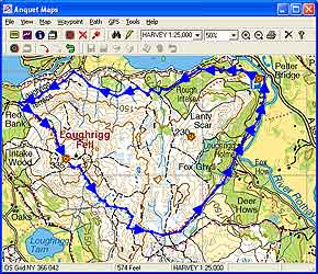
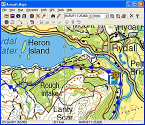
Click on the map for a full sized image
Reproduced from Harvey Maps 1:25,000
Superscale Lake District mapping © Harvey Maps.
All rights reserved. |
I have a slight terminology problem with Anquet, a route is a collection of one or more paths. I am used to a route being a single set of points. This isn't a problem and indeed you can just use one path as your route. Being able to associate a number of different paths into a route is very useful when you have common access to a set of different journeys, or there are a number of options available for a particular walk. If all of these are arranged into joining paths and the options are then collected together as routes. It sounds complicated, but really it isn't.
Waypoints can be added either to the path/route or placed at specific locations on the map. I find that when walking in the mountains I like to know how far away a certain peak is. I was able to use the search facility to locate the mountains and then place a waypoint at the top.
Once you have created your path/route you can save it, print it or send it to the GPS handheld. I really like the idea of printing the maps, complete with route info, as I also have a laminator. This creates some wonderful waterproof, virtually indestructible, annotated mini maps. When you have finished with them either throw them away, or if you are like me save them in a completely disorganised manner. |
|
Interfacing with the GPS
OK so you have you map all set up and ready to go you have printed it out, possibly laminated it. Is that what it is all about then?
Well it could be. But no: Anquet Maps also has a GPS interface to allow you to download your data to a GPS.
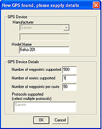
When you first connect to your GPS Anquet maps presents the New GPS dialog box. In the case of my receiver, the Garmin Geko, there was no inbuilt support for it. This wasn't a problem as the software read the model from the GPS receiver and then set up sensible defaults for the number waypoints, routes and waypoints in the route. All of which could be adjusted.
When a route is transferred it is given a prefix such as "AA" each leg of the route is assigned an incrementing number. So your route will have points in it AA0001, AA0002, ... AA0034,AA35. When you download a second route the Prefix is incremented, though you can control the prefix to an extent. This means that the next route is "AB", then "AC" etc.
Waypoints can also be transferred to the GPS. This is achieved by highlighting the waypoint and selecting save to GPS. You will then be prompted to provide a name for the waypoint prior to it being sent to the GPS.
|
|
I spent some time entering details of some of the Wainwright Peaks in the Lake District and then naming them in the quick list. I was hoping to be able to do a mass transfer with the waypoints picking up the names from the quicklist. This didn't happen and would be a nice feature to add in in a later release. |
The Ordnance Survey 1:50,000 scale maps
The OS maps are supplied in two sections dividing the UK into 2 sections: North and South. The North/South split occurs roughly in a line across the country from Grimsby through Doncaster and to Wigan in the West. Each section of the country is supplied on 4 CDs. One CD contains the installation programmer.
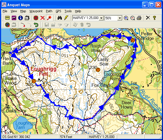
What can you say about the maps? Not a lot really there are of the sort of excellent quality that you would expect from the Ordnance Survey. The sample to the left shows a route planned on the Ordnance Survey maps over Loughrigg Fell in the Lake District. If you click on the map you will see a full sized sample of the map.
The definition of the maps is very good and they also print well when printed on a good quality inkjet printer.
The only problem with the maps is that they are 1:50,000 scale and not the 1:25,000 normally associated with fell walking. Whether or not that would make any difference for the GPS interface is debatable, but the larger scale is handy for serious hill walkers.
|
Click on the map for a full sized picture
Reproduced from Ordnance Survey 1: 50,000 mapping © Crown copyright. All rights reserved. |
|
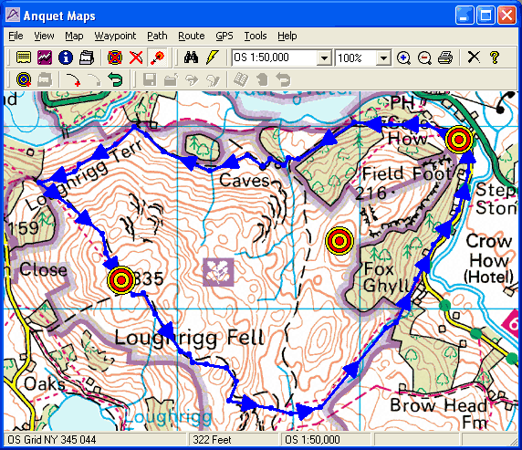
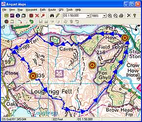
The Harvey Map 1:25,000 scale maps
Harvey Maps are currently the only commercially available digital land maps of the UK at the popular walking scale of 1:25,000. The maps I reviewed were the Superscale Lake District. They come on a single CD complete with the Anquet Maps application.
These maps are again faithful reproductions of the popular walker's maps. The digital maps are actually produced from the same digital source as the paper Harvey's Maps, they are not scanned from paper originals.
As you can see from the detail they are much more useful for detailed navigation for outdoor pursuits. Once again the definition of the maps cannot be faulted, and the colours are nicely contrasting making the maps easy to read in less than perfect lighting.
Clicking on the map will display a full sized map. Using the 1:25,000 scale mapping products allow greater definition nd detail, resulting in more accurately planned routes.
The Superscale Range of maps cover the English Lake District and selected areas of the Scottish Highlands at 1:25,000 scale. |
Click on the map for a full sized picture
Reproduced from Harvey Maps 1:25,000
Superscale Lake District mapping © Harvey Maps.
All rights reserved. |
The main benefit of the Harvey Maps comes with the freedom and openness that Harvey apply to their copyright and licensing. Having spoken to both Harvey Maps and Anquet Maps to ascertain their positions regarding use of their products I have been informed of the following:
Harvey Maps are quite happy that once you have bought one or more of their products for you to use that product in any way you want to for your own personal use. For paper maps this includes scanning into a computer graphic image format and calibrating it and displaying it on your PDA. For digital maps you may take screen dumps and combine them into larger images and calibrate them for use on your PDA. You MUST have bought the original source and you may not distribute any images to any other people.
Anquet, in principle, allow you to reproduce images in digital, or printed, format and use them in any manner for your own personal use.
The terms of the license for Ordnance Survey maps prohibit the manipulation and calibration of their mapping products in any way.
In keeping with the above restrictions it is possible for PDA users to purchase Anquet Maps with Harvey Maps Superscale digital maps, and create calibrated digital images for use in PDA navigation packages. This gives you access to 1:25,000 scale digital maps of some of the most popular walking trails in England and Scotland. |
|
|
The Anquet Maps website
The Anquet Maps website at www.anquet.co.uk apart from providing a wealth of sales and product information is also a community. One of the great features of this community is the ability to share your routes with others.
A section of the website is entirely devoted to the submission, search and retrieval of routes. To use one of these routes all you have to do is simply to download the .arf file onto your computer and then load it into Anquet Maps. This really is a neat way to share your experiences of our wonderful countryside with other like minded people. |
| Education
The Anquet Maps package is an ideal tool for teaching orienteering. If you are an educational establishment then this is an excellent alternative to buying Paper Mapping products. As an instructor you can take the base mapping date and add value to it. I wish we had had something like this when I was a scout. These really are disposable maps, you can set out the route you plan to take make notes and print the notes, then laminate the lot into exercise packs. A novel and flexible educational tool.
Please check the Anquet web site for eligibility and terms of use for educational entitlements. These should apply to Schools, Colleges, and youth groups such as the Scouts, Guides, YMCA and the DoE Award scheme. |
| Conclusion
This package is ideal for the hikers, fell walkers, outdoor pursuits enthusiast etc who want to be able to record and annotate walks, trips and expeditions.
The quality of the maps is difficult to fault. The accuracy of the maps and the calibration of the maps appears to be very accurate in the few spot checks I have been able to perform. A quick comparison of some of the areas of the digital maps compared to current and old (circa 1960) maps shows conformity of information (as you would expect).
It is an excellent tool for educators teaching the essentials of map reading and orienteering. Allowing very flexible, modular and innovative exercises to be created.
It provides the functionality that users of handheld GPS devices need to create and manage accurate routes and waypoints within their GPS receivers. Not forgetting, of course, the flexibility to create and manage an infinite number of routes and waypoints. There are some tweaks that could be implemented which would make the management of the GPS more easy to use, the most obvious is the export of the waypoints in the quick-list.
I suppose that the ultimate improvement would be the addition of a PDA interface allowing the digital maps to be transferred to either an existing PDA application format, or to create an Anquet PDA application.
For PDA users the main benefit of purchasing Anquet would be to download the digital Harvey Maps at 1:25,000 scale. This to me would be an excellent reason to purchase the Superscale Map products. |
|
Digital Scanning of Maps and Downloading of Digital Maps Disclaimer
All maps do hold a copyright notice to prohibit the copying of the maps. Please check the terms and conditions of the copyright and your rights before digitally scanning any paper maps or downloading of any digital maps from websites or other locations. Most mapping companies will grant you a license to make at least one copy of the map for personal use only, however please check first and if requested to do so, request permission from the copyright holder first before scanning or downloading the digital maps.
Ordnance Survey Copyright Restrictions
Permission to scan an Ordnance Survey paper map (which is less than 50 years old) for retention on a retrieval system must be requested in writing stating the purpose of scanning Ordnance Survey maps, scale of mapping to be used and total area to be scanned in cm squared at original scale. Permission will not be given if the customer can be supplied with an equivalent digital mapping product from Ordnance Survey. A one off data royalty charge will also be applied, calculated using the number of mapping units scanned, and the customer must hold a Digital Licence with Ordnance Survey. |
|
|
 |
 |
 |
 |
|
|