Review by Lutz Bendlin
Introduction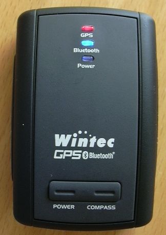
GPS data logging has come a long way since the early days (remember the Deluo Blackbox ?) . Devices have become smaller, more sensitive, and show a longer battery life.
BuyGPSNow have asked us to review the Wintec WBT-100 Bluetooth GPS receiver. When I first heard that it can only record 12.000 data points I was disappointed. When will someone come up and challenge the 50.000 data points of the DeLorme Blue Logger ?
Anyhow, I gave the WBT-100 the benefit of the doubt, and I think it was worth it. Read on for the nitty gritty detail.
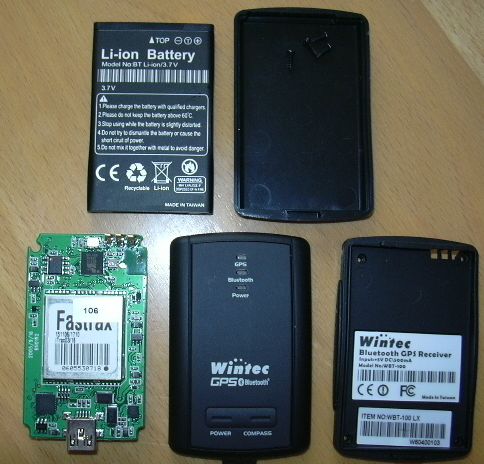
The WBT-100 is advertised as "Extra tiny size with most powerful features". The picture reflects the actual size of the device. It really is tiny. I think the limiting factor is the size of the battery (thankfully a replaceable rechargeable Nokia style battery).
The first thing that catches your eye is the word "compass" on the cover. How would that work? Actually, very well. But more about that later.
What's in the box?
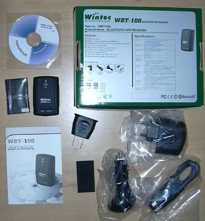 You've got You've got
- the receiver
- a CD with the G-Tool program for PC and Pocket PC
- the battery
- a very misleading User's manual leaflet (best to be ignored)
- a USB car charger adapter
- a Euro USB power adapter with North America adapter
- a standard Mini USB cable
- a little rubber mat. More about that later.
The CD contains the aforementioned G-Track program for Windows PCs. You can ignore the version on the CD and get an updated program from the Wintec web site.
What you should use the CD for is the USB to Serial bridge driver - you will need to have that installed if you want to communicate with the device via USB.
Installation
If you want to use the WBT-100 only as a Bluetooth receiver for your PDA then you are done. Just find and pair it (pin code 0000) and off you go.
However, if you want to use all the bells and whistles then you need to install the G-Tool on the PC. Once this is done, run the "Preinstaller.exe" from the "USB Driver" folder on the CD. This will install the well known USB-Serial bridge driver.
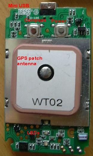
You may have noticed from the list above that the USB cable seems to be missing something. Holux and other receivers come with a "soap box" USB cable housing the USB to serial converter. Thankfully Wintec have eliminated that hump (or to be more precise, have included the circuitry in the receiver's PCB) so any standard Mini USB cable will do. Very commendable.
And yes, the USB cable does also provide the power to the device and charges the battery.
You can also connect the receiver to the PC via Bluetooth, however the G-Tool only lists COM ports up to COM15 - clearly insufficient if you get a port COM37 assigned by the Microsoft XP Bluetooth stack.
Wintec support later told me that the COM port can also be entered manually, and I was able to confirm that.
Setup
The G-Tool program has a number of important settings, and quite a few of them are not mentioned in the leaflet. If you want to learn more about what the program does, read the real manual here.
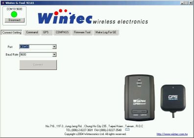
First you need to specify the COM port (the actual number will vary from PC to PC, on mine it is COM10 for the USB/Serial port). Leave the speed at 9600 - that seems to be the most stable.
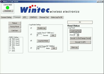
The Command screen is where the bulk of the interesting stuff is. Most importantly you can set the logging parameters. You can decide between no log (how lame), time based log (every x seconds), range based log (every x metres), and a combination of the two, called "Log Auto Mode". I selected that one because it seemed the most sensible to me.
On the right hand side you see the options to read the log from the device, and save it as text or GPX. GPX is the GPS XML format, something that should be understood by the majority of today's converter programs.
You can also clear the log. However, the log is a circular buffer (the oldest data gets overwritten if no space is left) so you don't really need that feature unless you want to sell the device and don't want the new owner see your logs.
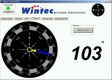
The compass feature at first didn't appeal to me at all. I mean, how good can an electronic compass be? I know it is a standard feature in american cars, but hardly anyone ever uses it.
However, keeping in mind that for example the TomTom map tends to rotate quite a bit when your car is standing at an intersection, I started to look a bit more into the compass function.
Before you can use the compass you have to calibrate it. Since it is influenced by any magnetic material that may be in the proximity you should calibrate the compass always before you take a reading. Even a small magnet like the ones on the underside of some GPS receivers can instantly void the calibration.
Calibrating is done by depressing the compass button until the light becomes orange, then turning the device around its vertical axis for a few times, and finally depressing the button again. If you decide to turn together with the device make sure you are not in a dangerous place (or are immune to vertigo).
To use the compass you press the button briefly. The LED will blink, infrequently when you are in a "cold" place (pointing south basically) and more and more frequent when you turn to the north. Exact north is achieved when the LED is steady. This is only happening in a tiny arc, so you should really be able to point north reliably.
One thing I did not like about that feature - you can only have a GPS reading sent to your computer OR do a compass reading. The NMEA data stream will be interrupted while you are in compass mode. No idea why this has been done.
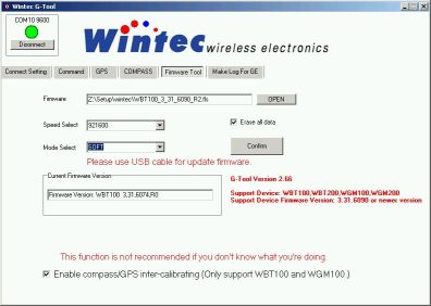
Oh, the joys of firmware upgrades. Well, technical progress, uhm, progresses, so you should always check the Wintec website for a more up to date firmware. In my case this meant I could upgrade from 6074 to 6090. Is it worth the hassle? The change log states
Ver. 3.31.6090 R2
1.Update new GPS kernel
2.Add enable GPS/Compass inter-calibrating function
3.Add hardware Cold Start function.(Let WBT100 to compass calibrate mode then turn off WBT100)
Inter-calibration function? Interesting! Exactly what we need to make these maps stop turning on the spot when the car is stationary! The caveat is that obviously you need to position the receiver always in the same way when it is in the car. And you have to calibrate it while being in the car. Here it is - your licence to drive in circles. Don't care what other people say about you - you know it has a purpose. You need to calibrate the compass...
After the calibration is successful the compass will deliver bearing data to the GPS module when the speed is low. I am not entirely sure but I also think that at higher speeds the GPS module delivers the bearing information to the compass, to refine the calibration.
The hardware cold start may come in handy after a plane trip, or if you want to start from scratch for any other reason.
Make sure you use the USB cable for the firmware update, it will not work over Bluetooth.
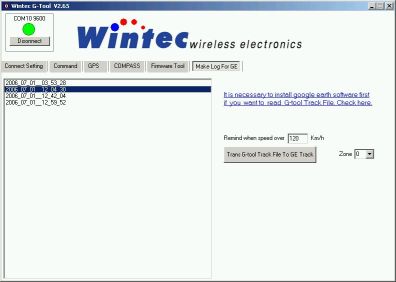
Once you have loaded the data log you can also convert it to a Google Earth XML format (KML). If Google Earth is installed on your computer then you can display the track or tracks right away. You can also indicate a speed limit - if any reading goes above that then the marker will be displayed with an angry red car instead of a innocent blue dot. Wohoo.
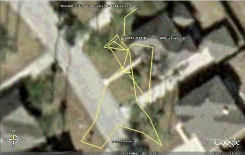
The track log here also shows one of the weak points of the receiver. The chipset tends to jump around quite a bit over time. The receiver was stationary, indoors but with good skyview through the paper roof of my house.
There is also a version of the G-Track program for the Pocket PC. But that is limited to setting the log mode, and to download the raw data log to the root of the PDA. Maybe this will come in handy when you are doing a longer trip, and are afraid that the log data gets overwritten due to the small size of the log buffer.
So each day you could save the current buffer (don't forget to transfer the file to storage card afterwards) and when you get back to a computer you can convert the raw data logs to text or XML files.
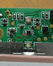
Inside the receiver
Disclaimer: we open the receiver up so you don't have to do it. It will void your warranty!
The receiver is really nice and small. It feels and looks well built from the outside, so I was curious how it looked inside. It is not easy to open the battery cover. I found that it is best to pry the halves apart with a finger nail, at the opposite site of what the manual tells you.
The rest is easy, there are four small screws that hold everything in place. Note there is no seal around the case, so the receiver is not watertight. But it should be reasonably protected against the occasional drop.
The Mini USB connector is protected with a little rubber flap. The receiver als has the lanyard loop built into the case. As mentioned before the box contains a little rubber mat that you can glue on to the under side of the case. This will greatly reduce the movement of the receiver on the car dash. I believe this is a very thoughtful addition.
Receiver performance
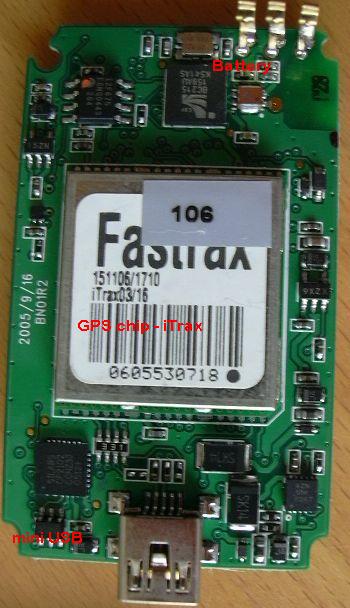
The iTrax chipset performs rather average. Position ccuracy is good while moving, but the receiver is jittery in stationary mode. It also does not seem to be as sensitive as the SiRF III chipset when subjected to indoor conditions.
Battery runtime is stated as 17 hrs - I found it to be in the 16 hr range (without BT). The receiver employs a number of smart techniques to keep the power consumption down. Most notably you can switch off the Bluetooth transceiver while keeping the GPS data logger alive.
So for example when you are hiking, and want to record the whole trail you can do that without wasting power on the Bluetooth module. When you are stopping to verify your position you can quickly enable Bluetooth (press the power button briefly) and the NMEA data will be sent along. When you are done press the power button again, and Bluetooth will be off while the data logging continues.
The Bluetooth module will also switch off ten minutes after the last Bluetooth activity.The GPS module will not switch off, which means it will eventually drain the battery. The log data is stored in Flash, and will not be lost in such a case.
Thanks to the integrated USB Serial bridge the receiver can also be connected to a PC's USB port, and can be used with PC navigation programs. Nice.
Another very nice feature - when power is applied to the receiver it will switch on. This means despite the software power button you can actually use this receiver hard wired into the car. All you need to do is to establish a Bluetooth connection to it within 10 minutes of turning the ignition on.
 Annoyances Annoyances
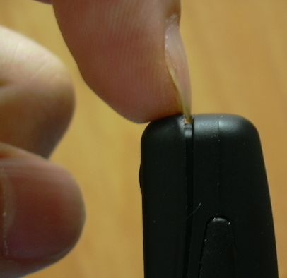
Well, being a device from Taiwan, the receiver blinks as if there is no tomorrow. Yes, you guessed it. The GPS LED blinks when it has a fix, the BT LED blinks when there is a BT connection. Everything opposite to what it should be.
In addition the blue LED is extremely bright. I was using my previous "Inside the receiver" exercise to paint the LED with a black permanent marker. You can see that in the picture (it is the LED in the middle). Now the light output is at least bearable.
I already mentioned the fact that when you switch into compass mode the GPS module is halted.
I believe the shipped version is set to do time based logging (every 10 seconds) - it would have been better if the default mode would be the Auto log mode.
|


