
 Review by Mike Barrett Review by Mike Barrett
TomTom GPS for Palm OS Tungsten T3 PDAs
At the beginning of the year we reviewed our first Palm OS navigation system. About the time that we released our review both TomTom and Navman announced GPS navigation packages for the Palm Tungsten PDAs. Life was about to get interesting.
We can now bring you the first of these reviews "TomTom Navigator for Palm T3". Thanks to PalmOne who have loaned us a Palm Tungsten and TotalPDA who provided the GPS bundle for review.
TomTom really do not need introducing here, but just in case you have been
in outer space for the last couple of years... TomTom are one of the top providers of GPS navigation systems for PDAs. They originally provided some early software which was bundled in with other major GPS player's hardware. TomTom Navigator is widely recognised as being one of the best GPS programs for the Pocket PC. Now it has been released on the Palm platform.
This review looks at the TomTom Navigator for Palm GPS Navigation Pack (wired GPS and bluetooth).
TomTom Navigator GPS Navigation pack for Palm OS Overview
The TomTom Navigator for Palm Tungsten T3 is marketed as "No hassles, no software installation, plug and go". Indeed it is quite a different beast compared to the Pocket PC TomTom Navigator. Read on and find out why...
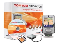
TomTom Navigator for Palm is a complete solution. All you need to do is supply the Palm Tungsten T3, and yes it only works on the T3 (we tried the T2 and it crashed). You get the mount which can be wired permanently, the GPS (either a wired GPS or a Bluetooth GPS), the software pre-loaded on a SD card, and a CD with the major roads of Europe on it.
TomTom announced a new product at CeBIT called Go. Click here for the press release. This has a new navigation engine and because of the look of the interface many people mistakenly thought that it was a Palm based system. It is not it is PDA hardware based with a completely different operating system. What TomTom have done is to create a new navigation engine which is platform independent and then all they have to do is change the user interface. This means that they can have a core navigation system which is common over all the hardware versions and just a small bit of software to provide the user input and display functions. Using this principle they can roll out Navigator on multiple devices quite easily. We have already seen TomTom Navigator working on a Pocket PC, Palm, Sony Ericsson P900, and Nokia 6600 using this mechanism.
Anyway, getting back on track, this review looks at the core components of the navigation system individually, and follows up with a comparison of features between TomTom Navigator 2.24 and TomTom Navigator for the Palm. This should also give you some insight as to what functionality is going to be available in TomTom Go. |
 |
During our testing we went over to CeBIT and, with a SD card provided by TomTom, tested out the German maps. That must have been an interesting sight a Ford Mondeo loaded down with 3 of the PocketGPSWorld.com team and overflowing with GPS gear.
TomTom Navigator for Palm Mounting System
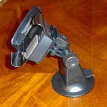
The mounting system is the TomTom car kit for the Palm. This is a dedicated suction holder with power and GPS signal cabling. Unlike most suction systems this is a rigid elbow joint system which means that the whole system is held solidly. If you have the Bluetooth GPS receiver then there is a cable provided to connect to the power input of the BT GPS allowing the unit to be charged whilst you are on the move.
 Power to the mount can be supplied in one of two ways: a cigar lighter adapter and a hard-wired cable. Both of these solutions are provided in the package. The instructions did not make any mention of the hard-wired cable connections or requirements. I assume that the mount actually has a voltage converter in it so that the cable can be wired directly to your 12 volt circuit. There is no in-line fuse supplied so one should be added if you are going to use this power solution. There is no specification (that I found) for the supply voltage. I am concerned that lorries and other vehicles with 24 volt electrics could cause problems. Power to the mount can be supplied in one of two ways: a cigar lighter adapter and a hard-wired cable. Both of these solutions are provided in the package. The instructions did not make any mention of the hard-wired cable connections or requirements. I assume that the mount actually has a voltage converter in it so that the cable can be wired directly to your 12 volt circuit. There is no in-line fuse supplied so one should be added if you are going to use this power solution. There is no specification (that I found) for the supply voltage. I am concerned that lorries and other vehicles with 24 volt electrics could cause problems.
As with most of the PDA mount systems nowadays the components are made in Germany. They are of top quality and I have been using the system for over a month now and have not had a single problem with it. As they are made by a single supplier you will find that a lot of the generic mounting systems have parts that are interchangeable should you want to use them for whatever reason.
The mount itself holds the Palm Tungsten very snuggly. When I first put the PDA in I really had problems as the fit was very tight. It has loosened up a bit now, and I have got used to it as well and now the whole package is held very securely.
The Tungsten T3 can be operated in both portrait and landscape modes and thoughtfully the mount can be assembled in either mode as well. Unfortunately to change the mount from portrait to landscape modes requires the use of a screwdriver to remove 4 screws. One thing to watch out for when configuring the mount for landscape mode is that you make sure that you have the PDA on and in landscape mode otherwise you may find the screen upside down.
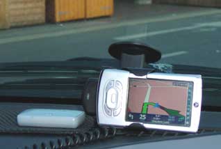 I am not a big fan of suction mounts, but this version has changed my mind. The sucker is large and has not failed once since I started to use it. It is also very flexible as to where it can be fitted. Not many suction mounts will fit my Chrysler Voyager as the windscreen is a little awkward and a long way from the edge of the dash. In landscape mode the system fits perfectly. I am not a big fan of suction mounts, but this version has changed my mind. The sucker is large and has not failed once since I started to use it. It is also very flexible as to where it can be fitted. Not many suction mounts will fit my Chrysler Voyager as the windscreen is a little awkward and a long way from the edge of the dash. In landscape mode the system fits perfectly.
If you don't want to use the windscreen then a second option is available. The mount is supplied with what looks like a drip tray for a plant pot, but actually it has adhesive tape on the underside and will attach to any reasonably flat surface and provide a perfect platform for the mount's sucker. They also double up nicely as coffee mug coasters.
The only real drawback about the mount is that it can only be adjusted in 2 planes and not 3. This means that if you do not have a flat place to put the mount you may find the PDA slightly tilted.
The TomTom Wired GPS Receiver
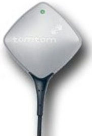 The TomTom wired GPS Receiver is the same as provided with the current TomTom 2 and TomTom 3 products. This has been well proven and is an excellent receiver albeit slightly larger than you most of the latest receivers. The TomTom wired GPS Receiver is the same as provided with the current TomTom 2 and TomTom 3 products. This has been well proven and is an excellent receiver albeit slightly larger than you most of the latest receivers.
One of the thoughtful accessories provided with the receiver is a small metal plate with an adhesive strip on one side. As most modern cars have plastic dashboards the GPS will normally fly all over the place. This small and thoughtful item fixes the GPS's magnetic base holding the receiver perfectly whilst allowing it to be removed quickly and easily if needed for security reasons.
The receiver has a cable of about 1.5 meters which terminates in a small square plug. This fits into the mount and provides both power and data signals. It is literally plug and go! There is only one place it will fit.
The performance of the receiver is very good, with a fix normally being achieved before I have reversed out of my drive. Gone are the days when you sit in the car fiddling for ages waiting to get a fix so you can start driving!
In use the receiver has a small LED which flashes red when there is no fix, or green when you have a fix.
Wired GPS Specifications
-
Based on SiRFStarII Architecture
-
Acquisition Time: Cold/Warm/Hot Start: 45/38/8 sec typical TTFF
-
Reacquisition Time: 0.1 seconds
-
Support Standard NMEA-0183 v2.0 and SiRF Binary protocol
-
Support Accurate 1PPS Output Signal Aligned with GPS Timing
-
Trickle Power Enabled for Power Saving
-
Superior Sensitivity for Urban Canyon and Foliage Environment
-
Magnet base for mounting on the car
-
Operating temperature: -40 ºC to +85 ºC
-
Power: 5.0 +-5%V DC input internal rechargeable 3V lithium battery
-
External Power: Universal connector for Pocket PCs
-
SiRF Binary plus proprietary messages NMEA-0183 v2.0 GGA, GSA, GSV, RMC, VTG, GLL
-
Baud Rate: 4,800 to 38,400 bps
TomTom Bluetooth GPS Receiver
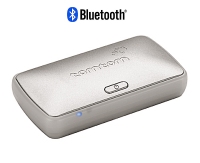 The Bluetooth GPS receiver supplied with the Bluetooth version of the TomTom Navigator package is the same as the Pocket PC version. The accessories that are provided with it are slightly different though. The Bluetooth GPS receiver supplied with the Bluetooth version of the TomTom Navigator package is the same as the Pocket PC version. The accessories that are provided with it are slightly different though.
The base of the receiver is magnetic, like the wired version and is also supplied with a metal plate with adhesive tape to secure the GPS whilst driving.
The GPS can be powered, and charged when driving by using the supplied cable (RJ11 connector) from the mount.
In use the GPS was simple to set up and connect to the Tungsten. The connection seemed to be reliable most of the time, the only issues that I noticed were when I was using different bluetooth GPS devices and switching between them. This sometimes resulted in the software or the hardware not recognising the GPS correctly and not reporting a position. This issue was resolved simply by soft-reseting the Palm, an almost unheard of occurrence. There have been several reports in our forums of this behavior occurring when the only GPS in use has been the TomTom BT GPS, but I have not observed this myself.
Acquiring a fix was always fast, the only exception was when I flew from the UK to Germany and the receiver took about 3 minutes to get a fix. Apart from that the normal morning startup time was less than a minute on the whole.
The accuracy of the reported position was comparable to other GPS receivers. The technology has moved on so much in the last 12 months that is is almost impossible to get a bad fix, unless you are in an "urban canyon" and even then position is normally reasonably accurate.
Bluetooth GPS Receiver Technical Specification
- SiRF IIe/LP
- NMEA 0183 version 2.20
- Bluetooth version 1.1
- Hot start: 8 seconds
- Warm start: 38 seconds
- Cold start: 45 seconds
- Reacquisition time 0.1 sec
- Lithium-ion battery (non-replaceable)
- GPS and Bluetooth 5-6 hours usage per charge
- Industry standard low power consumption
- Internal patch antenna
- External antenna via MC female connector (not supplied)
TomTom Navigator for Palm software
OK so that is the package contents described, so what about the software?
The first thing of note is that this is not a conversion of the Pocket PC TomTom Navigator software. TomTom have been beavering away creating a whole new navigation system. This is their new Navigation engine which is going to be at the heart of all new navigation products from TomTom over the next few months. It's first public appearance is the Palm version, but will be followed shortly by the TomTom Go dedicated navigation unit, and later with versions on Mobile Phones.
TomTom tell us they have been listening to user feedback and have developed the new navigation system taking this on board. The main consideration has been in reliability. When trying to launch systems into the mass market the primary considerations are trouble free installation and configuration and ease of use. To a certain extent this has meant that some of the functionality of TomTom 2 on the Pocket PC has been sacrificed for 'usability'. So how does it shape up?
Installation
First things first we need to install the software. The package comes supplied wit a CD containing the software and also a SD card with the software and maps pre-installed. Installation is a simple as inserting the card and then following a simple installation wizard, which takes you through the entire installation and configuration process in a non-technical and 'idiot-proof' (well I installed it!!) manner.
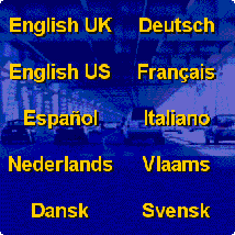
Installation starts by asking you your language |
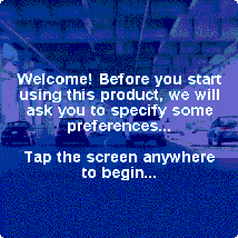
Then proceeds with a full install and configure wizard. |
To view the full sequence of the installation wizard click here. This his will open in a new window and shows the steps involved in the installation and configuration of the software and hardware.
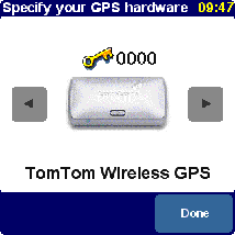
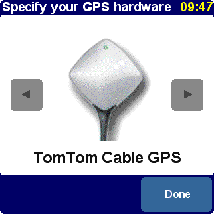
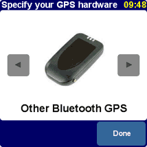
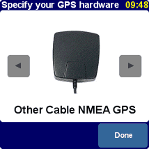
The screens below show the configuration screens for the GPS receivers. There are four different types supported: TomTom BT GPS, TomTom Wired GPS, Other BT GPS, and Other Wired GPS. |
 |
 |
 |
 |
And that is all you need to do to install and start navigating.
Having said that I am not sure how this is going to affect people using TomTom Navigator for Palm in America. We have had some feedback that the installation is not quite as straight forward, and that the software and maps need to be installed from the CD using HotSync. A lengthy and
less intuitive process.
Looking at the software installations that I did for both the UK and Germany I would say that this really is the way to install software. Full marks to TomTom here.
Software Activation
One of the things that I noticed that was missing from the installation is the need to activate the software, something I really hate. On the Pocket PC you were limited to the number and frequency of installations that you were allowed. Not a problem for people who keep their batteries topped up, never upgrade ROMs or do hard resets, if you do though this can be a real pain. This has gone away with the Palm version of the Navigator. Why I hear you ask? Quite simply because they don't need to any more. The software supplied on the SD card is limited to work only with that card, all SD cards have a unique serial number. Therefore no activation required.
One thing to look out for of course is that you don't try to use the SD card for another purpose and expect to be able to run TomTom on another.
TomTom Navigator for Palm in use
When you have installed the software you are ready to go (no pun intended). When you start the Navigator application the first thing that happens is that you are given a tour. This identifies the different parts of the application and the different functions available.
 |
Just to whet your appetite we have included the images from the tour on a special page.
Does this sound familiar? Free tours? Well you won't be asked for your credit card details at the end of this one but you may be tempted to pass that information to one of our advertisers to buy the setup.
Click here to view the
TomTom Navigator for Palm Tour.
This will open in a new window so just close it to return to this page again.
So that was TomTom's version of the features of the software what about our impressions? We used the software extensively for 6 weeks both in the UK and Germany with very few problems. Indeed it really does seem to live up to the promise of "Plug and Go"
|
The Palm Tungsten is the first Palm device to have a soft silk screen, which can be used as part of the main display area. What does this mean in real life to the user? Well instead of being stuck with a screen of 240 by 320 dots (as the Pocket PC users have) or 320 by 320 (as the Palm Tungsten T, and T2 users have) the Tungsten T3 can display a massive 320 by 480 dots. Twice the size of the Pocket PC! It can also run in a more compact 320 by 320 mode just by closing the PDA.
Not only that but you have the option of running either in portrait mode, or landscape mode. All of this is achieved out of the box and is fully supported on the Palm OS. You may need to apply a Palm OS upgrade to use these features.
So what does this mean to us non-technical users? Simply that you can display more information on the screen. Is this a good thing or a bad thing? I will not make a judgment, I will just let the pictures tell their own story.
Displays
There are two main displays for TomTom: Navigation mode and Map mode. With the new navigation engine the Map mode has been very much relegated to a utility rather then a main display.
The image to the right is the 3d Navigator screen. The bottom section of the screen is the control and display area.
The Blue arrowhead is your current position and this will remain in that location with the map moving to keep the view "heads up" ie always showing the direction you are driving in.
To access the controls of the software you just tap on the map area of the screen. Tapping on the next direction repeats the last instruction, whilst tapping in the other information area will display the planning screen. |
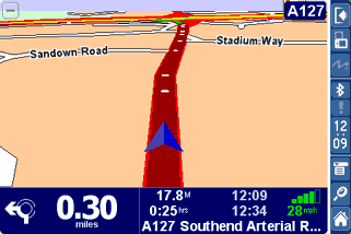 |
The shot above shows a 3d navigator display, there are options to either display the map in 2D or 3D. Some later images show the differences between the two different navigation displays.
The two screen shots below show the planning screens and the difference that the additional screen space makes. There are 3 large buttons at the bottom of the screen which allow you to select: the route instructions; the Map mode; or return to the navigation mode.
The bar down the right hand side provides some additional information about the state of the battery and the number os satellites used in the fix. This may not seem like an important display, but if you have a Bluetooth GPS you may make the mistake I did once by not placing the PDA in the mount properly, and consequently running on battery power. It doesn't take long to drain a PDA battery with the backlight on full.
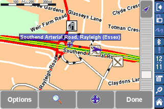
The final screen is the Map Display.
In previous versions of TomTom this has been given a high ranking on par with the navigator screen. With the latest version the Map Display has been relegated to a utility.
The map is always displayed "North Up", as a paper map would be. Your position is still shown live on the screen.
A good use of this screen is to see your overall position in your journey, though this could be a bit depressing when you have only just started on a long journey. |
 |
 Planning a Route Planning a Route
Planning a route is pretty simple. All you have to do is to tap the Navigator screen and you are presented with a large display showing 5 buttons and a a more button. OK so that is six isn't it?
Tapping on the "Navigate to..." button displays a secondary screen with six options on it: Home, Favourite, Address, GPS Position (?), Recent Destination, and Point of interest. Tapping one of these items will bring up further prompts to find the location that you want to get to.
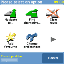
This is the main options screen, this will be described later. |
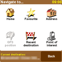
The main navigation screen gives options to navigate to home, a Favourite, an address, the GPS Position, a recent destination, or a point of interest. "home" is a special favourite and is designed to allow you to set a route fro home with only two taps. |
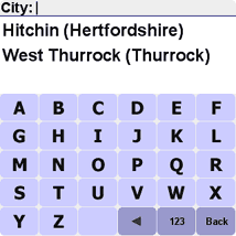
If you select the address option you are taken through a series of prompts to locate the precise address. TomTom Navigator remembers the last places you visited and provides shortcuts to them. |
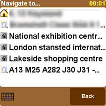
If you select the Recent destination option you are presented with a screen of the last few places that you have planned a route to. You simply tap the one you want to plan a route to it again. |
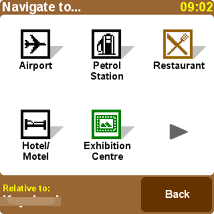
If you want to find a particular place then you need to navigate to a point of interest (POI) the first screen displays some common POI groups, when you select others TomTom learns and displays them instead. To select another POI group tap the arrowhead. |
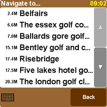
I have decided to find a golf club. TomTom will show a list of places starting with the one nearest the current GPS position (as the crow flies) and then getting further away. There is a separate section on POIs later. |
When your destination has been set then TomTom will calculate the route for you. This will be displayed on the summary route screen.
From here you have 3 options :
· Route - displays your turn by turn instructions
· Map - displays the route in Map mode
· Done - returns to the navigator display
Well that is the journey planned get driving... |
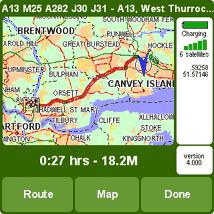
|
Route Quality
Routing is one of those areas where there is always a lot of heated discussion with people claiming that the routing is poor and doesn't produce optimum routes. Well that is always going to be the case as far as you are concerned around your local area because you know all the little tricks to save a minute here and that small detour to get you past a well known bottleneck, whereas the navigation software does not have this advantage. Not only that but you may well know that one short cut works well at 9:00 in the morning, but at 3:00 it just doesn't work. How do you fit that wealth of local intelligence into the navigation application. Well the simple answer is that you don't!! Anyway how many times do you take the shortcut and find you cannot get out at the other end?
Enough of all that. The real question is: "does the planned route get you to your destination easily and without problems?" Well here the answer is almost always going to be yes. There will be a few occasions where the map data is not up to date or there is an error in the map data. This is not really the fault of the software provider, but the mapping company.
A case in point is the new M6 toll road in the UK which is not on the supplied maps, Not a real problem as the M6 is still there and you will still get to your destination won't you? Well yes you probably will, but the introduction of the Toll road has meant that a lot of the junctions have changed and exits are not where TomTom is expecting them to be. Try getting to the National Exhibition Centre when approaching from the south and even the road signs are poor. I came very close to going the wrong way, and I have been there many times before.
Another example is bad mapping data. TomTom will route you along roads that the mapping data provider tell them are of particular types, grades, and speeds. This is fine untill you find that The mapping data company have got it wrong. When leaving my house and heading in a particular direction TomTom will try and route me of a major A road down a residential road, through an unmade road, to join back with a second major A road which intersects with the original. Obviously TeleAtlas have not surveyed the road correctly, or if they have it is given the same priority as the A roads. Interestingly this doesn't always pick this route so it must be marginal. This routing issue is the same for all navigation product using TeleAtlas data.
Having said that I feel that the routes generated are normally the ones that I would use, in areas that I know well. So far there has never been an occasion that I didn't arrive at the place I was heading for in what I considered to be a reasonable route.
Driving the Route With the route planned you set off in the car and you get the voice guided instructions in the language, and accent of your choice. But what is the interface like and how can you control it?
When you are driving there really isn't too much to do. You just drive and follow the voice instructions. If for whatever reason you deviate from your planned route TomTom will automatically re-route you back to your destination, either by returning you to the original route, or by creating a completely different route.
First things first. Normally you will see your navigation screen in glorious colours, but when you first start the application it may be shades of grey.
DONT PANIC, there is nothing wrong, it is just that the GPS has not got a fix yet. In fact this is a really good feature of the software. You instantly know if what you are glancing at quickly is up to date and accurate.
As soon as the GPS gets a fix your screen will be returned to the normal colours and your position will be displayed. |
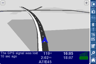 |
There are three screens you can use whilst driving. The first is the map display which was discussed above and really more of a planning tool, the second is the Navigation screen to the right, and the third is the Instruction screen detailed below.
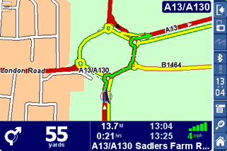
As you can see the navigation screen is packed with information. Your position is always displayed in a "heads up" manner showing you the road layout as you are driving it.
With the Palm Version of TomTom Navigator road names are shown on the display. |
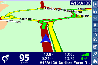 |
There are two ways to view the Navigator display either in 2D or 3D. I prefer 3D but the choice is yours.
The information along the bottom of the screen is as follows:
- Next turn instruction
- Distance to next Turn
- Distance to go
- Time to go
- Next road
- Current Time
- Estimated time of arrival
- Satellite strength
- Current speed
|
 |
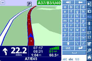
The screen to the right shows the difference that running with the silk screen keyboard, or with the Palm closed makes.
One column of data is dropped and the information is placed in another row.
Interestingly you would have thought that having the extended display you would get more map/route data displayed. Sorry that doesn't happen.
All you get is a small extra area and the main map is stretched to fill the screen. Do I feel cheated? Yes I do!! |
 |
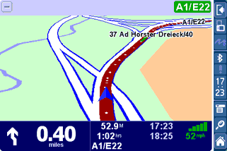
As you can see from the last 2 images on the right we used TomTom Navigator for Palm with the German maps.
This was an excellent test for us as we had absolutely no idea where we were going, and I broke one of my cardinal rules of not carrying a paper map with me.
Well there was no need. The quality of the German Map data was excellent. Despite one interesting route we managed to do about 1000Km in Northern Germany without getting lost except when the driver decided that he knew better than the software. Foolish or what?? |
 |
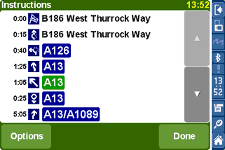
The final screen useful whilst driving is the instructions screen.
This displays a complete list of turn by turn instructions for your route.
You can tap the options button to bring up another screen which allows you to select what figure is displayed in front of the instruction:
- Distance to turn
- Distance since departure
- Time to turn
- Time since departure
- Estimated time at turn
|
 |
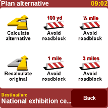 Alternate Routing Alternate Routing
What happens if you are driving along and you find that there is an accident or major delays ahead?
Well you simply tap the screen and select the "find alternative option. This pops up a second screen to allow you to select from a limited number of options to avoid roadblocks.
This is good if you see the end of a queue just ahead and can turn off, or if you are in a traffic jam and are approaching a junction.
The options you have are to calculate an alternate route, which I have never used, to avoid roadblocks of varying lengths, or to return to your original route.
The one thing that is missing from this is the ability to avoid roads by road name. This is a feature of the Pocket PC version of TomTom Navigator that I use a lot. A good example is to avoid the M25 when traveling during the rush hour (this is becoming anytime between 5:00AM and 23:00 nowadays). Hopefully TomTom will add this in a future release.
Application Options
The next sections I have split into the Application Options and the Application settings. The options are features that can be displayed or used, whist the settings are the configurable features of the software.
The Application Options are accessed by tapping on the main display screen this will show the screen to the right.
The first two options we have already described. The clear route simply removes the route and you just drive with a heads up map display.
The add to favourite option displays another r screen which allows you to create a favourite from any of the options that are available for creating a route, and also the GPS position (which will be active now).
The spanner icon allows you to modify the configuration and application settings described below.
The arrowhead displays the next screen of options. |
 |
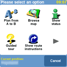
The second option screen allows you to:
Plan a route from 2 places not the GPS position.
Select the Map view option. When you tap on this you are offered a tour explaining the map features.
Show status. This pops up the route status screen as displayed after a route has been calculated.
The guided tour repeats the tour described above
The show route instructions displays the list of turn by turn instructions along your route. |
 |
Application Settings
Clicking on the spanner icon in the application options will display the first of 4 preferences screens:
GPS Setup
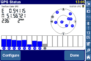
The GPS status screen can be reached in a number of ways, one is from the Application Settings as described above, another is to tap on the satellite graphic in the status display.
Either way you will be presented with the GPS status screen as shown to the right. This gives an indication of the number and strength of the satellites in view.
If you tap on the configure button you will be presented with the GPS selection screens as described above.
Tapping 'Done' takes you back to the navigation screen. |
|
Points of Interest :: POIs
The POIs that are installed with TomTom Navigator for Palm come from the mapping provider. Depending on the country you are in will depend on the type and number of POIs provided.
On the whole there are a large number available, but they are by no means complete. For instance looking at Golf Course POIs in my area less than a third of the courses are in the database. However that is probably an extreme example and really a lot of people use POIs to find the nearest restaurant, or bank etc so it doesn't matter if only 30% of them are listed you will still get to where you want to go.
One of the big plus points for the Pocket PC version of TomTom is User Customisable POIs. Indeed PocketGPSWorld.com has our own Safety Camera database and there are a large number of providers of add-on utilities to record and detect POIs. Sadly this has not been implemented for this version of TomTom Navigator. Rumor has it that customisable POIs will be added in a later release, but there is no word about 3rd party add-on applications.
Mapping Data
The previous sections have focused on the TomTom Navigator software but the software is only half of the navigation system. The navigation application succeeds or fails based on the quality of the maps.
There are 2 main technologies for map data Raster Graphics and Vector Graphics.
Raster Graphics can be thought of as a picture. It is made up from lots of individual coloured dots none of which have any relationship to the dot next to it. This sort of mapping is obviously no good for street routing as the software has no idea where the roads are.
Vector Graphics on the other hand are lines linked together to form a matrix of interconnected paths. These paths are assigned attributes (or labels) identifying certain properties such as name, type, etc. They even contain details such as speed, and direction. Obviously this data can be used to create a highly detailed map with all the sort of information required to get you from A to B without sending you to a dead end, or the wrong way up a dual carriageway.
There are two main suppliers of Vector based maps TeleAtlas and NavTeq. The Maps for TomTom Navigator for Palm are supplied by Teleatlas. They are dated October 2003, but that is the date they were released not when all the latest roads have been added.
The TomTom maps still provide complete coverage of a country or region. What you get is linked mapping data for those countries in the area, but if you buy 2 separate countries you cannot route between them easily. Therefore if you invest in the whole of Western Europe and commute between Switzerland and France, or Italy and Austria you cannot do straight through routing. You have to get to a border and then switch maps and complete your journey.
TomTom have recognised this as an issue and have included the Major Roads of Europe as a separate map section on the CD, which you can download to an SD card and use to navigate between countries. This is a vastly cut down version of the road network and will route you to minor roads, but not residential streets. This will work well for those of use who occasionally travel across Europe on holiday, but will not be too good when we get to the destination. Mapping Issues
There are two possible main issues with mapping data: The currency of the maps, and the accuracy of the roads attributes.
The accuracy of the roads attributes I described above, along with some of the currency problems you will get around the M6 Toll road.
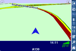
The picture to the right is not me driving over some poor farmer's field, but driving up a new by-pass that was opened nine months before the map data was released. Not only that but the planning had been known about for well over 2 years before that. By itself this is not a great problem if you live nearby, but it is difficult for people who do not know the area. |
 |
There really is no excuse for major road data that is that much out of date. This is not really an issue for TomTom but for TeleAtlas, however as TomTom sell the bundled data as a package then they will also get the fall-out from this. I expect there to be major issues with the M6 as this is one of the main and busiest sections of the UK motorway system.
On the other hand when we were driving from Hamburg to Hannover to get to CeBit this year we found that there were some autobahns that were under construction that we were correctly routed down and off at the end of the construction. Now either these had been like that for a long time, or the German maps are right up to date. Either way we had no problems navigating round this construction area. So I suspect that this is an organisational issue from TeleAtlas's point of view.
(If anyone from TeleAtlas reads this and would like to provide me with the real reason they are not able to update UK maps in a timely manner when companies like the Ordnance Survey can I will be very interested in having a discussion.)
Conclusion
Overall I was impressed by the ease of use of this version of TomTom Navigator. TomTom have put a lot of work into creating an infrastructure platform for future products.
I thought that one of the best features is the installation. It now really is straight out of the box, plug in and off you go. I wonder if this example will carry over to the Pocket PC?
The use of the Palm Tungsten in both Portrait and landscape modes and having the ability to use the silk screen was excellent. So much information on display. The only slight drawback was the stretching of the maps in navigator mode so you don't really benefit from the additional screen area as much as you could..
Despite the fact that there is quite a bit of functionality missing from the package (compared to the PPC version) it is mainly in the area of advanced features that most people probably will not use. The most glaringly obvious omission is the User Customisable POIs.
True to their other current product offerings the Routing is fast and accurate, the navigation and instruction is clear and easy to follow. Basically it does everything that you would expect a navigation package to do. |
Pros
- Complete navigation package
- Dependable Mounting options
- Excellent GPS receivers
- Fast and Accurate routing
- Really easy to set-up and use
- Landscape or Portrait screen modes
- Reliable and fast route recalculation
- Major Roads of Europe maps
Cons
- No User Customisable POIs
- Currency of the map data
- Some issues with BT GPS reported
|
The Final Word
I am a Pocket PC fan and not a Palm Fanatic. I now find that I will often forgo some of the enhancements that I am used to with the PPC version of TomTom to use the Palm system.
I suppose this means that I am becoming a convert. But it just goes to show that TomTom have got it right with this version.
All we need are customisable POIs and 3rd Party applications.
Review equipment supplied by

|