|
|
 |
 |
 |
 |
|
NAVMAN
SmartPath City (TomTom City Maps) |
22nd December
2001 |
|
Reviewed by Dave Burrows |
|
|
With SmartPath there are two
kinds of software. To try and stay close to the paper maps and to
keep disk usage to a minimum, two mapping programs were created. One
that gives you an atlas style maps
where you might want to go the length or breadth of the country, and one
that gives you A-Z style street maps for a specific city. The two
mapping programs are called Trips (Atlast) and City (A-Z).
Having the two
types of maps split out, sometimes is quite nice, but does hinder you.
Why does it hinder you ? Okay, let me try to explain. SmartPath Trips is one complete map of the whole of the UK, so you can
load the whole map onto your CF card and you've got the whole country in
Atlas form. If you are travelling from the south to the
north, then in most cases you would want an atlas style map, which Trips
gives you. However, if you
are also travelling through town centres then you will also want a street
atlas. Unfortunately the way SmartPath City is configured is that
you load the maps for a particular town or city and cannot plot journeys
between maps. If you were travelling from south
to north and you wanted to jump to a higher zoom level so you see more
than A or B roads on the City software, then you would have to turn off
the GPS Receiver, close Trips, load City, power on the GPS Receiver, and
then load the city map you are at, find your position and continue on your
way. As you can probably understand, this is a nightmare to navigate
through! Other GPS software are now coming with a single map, but
again because of the detail level.
Due to there being two
applications, we've split the review up into two, so you can see what each application
offers from the feature set.
|
|
  |
Now lets take a look at
SmartPath City. This application is best used for when driving
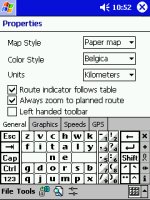
around a town or city. The Properties screen offers you a wealth
of features that can be enabled or disabled. You have the option
of changing the map style, colour of the map and units whether you
prefer miles or kilometres. A very cool feature for all those left
handed people out there is the Left handed toolbar. Perfect!
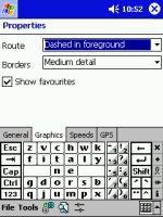
You can also change the
route highlight setting so it can be dashed in foreground, or a subtle
grey in the background whilst also changing the border details. |
|
SmartPath City really is a great piece of
software and it shows that this software is newer than the Trips
software.
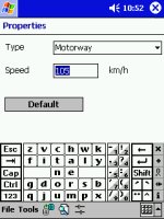
The two screenshots to the right allow you
to change the speed on particular roads. This is a definite
requirement if you're looking to plan routes and get from A to B by a
designated time, for instance you need to book into a hotel by 10pm.
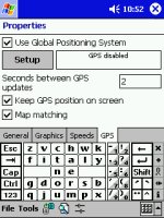
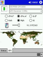
You also have the GPS setup screen where
you enable the GPS Receiver, change the update interval and map matching
(keeping GPS pointer to the closest road!) which unfortunately was left
out of SmartPath Trips. |
  |
|
|
|
|
 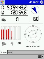 |
The GPS screen is very
similar to SmartPath Trips, in the effect that it actually uses the same
driver. You get the world map where you can change the format of
the degrees, speed notations and keep Pocket PC alive settings.
Going over to the GPS Status screen shows
you the latitude and longitude, with the direction you are pointing in,
how many Satellite fixes you currently have, and a general birds-eye
view of the earth which shows roughly where each of the satellites you
can see are positioned above you. |
|
|
|
|
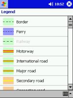
Now this is where the
SmartPath Trips and SmartPath City starts to alter direction.
SmartPath City gives you a
legend like you would see on most maps, allowing you to distinguish the
difference between say a ferry, motorway, major and secondary road.
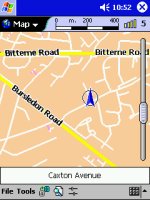
You can also see a 40%
zoom map here that shows the extreme level of detail that City Maps can
provide even at this small zoom level. Roads might look little
more than lines, but the higher you zoom in they start to look like
proper roads unlike other mapping software. |
  |
|
  |
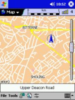
Okay, we've shown you around some of the
SmartPath City screens, by now you're probably itching to see how far
you can zoom into the maps. SmartPath City is actually a rebadged
version of the very popular TomTom CityMaps, and you will find the maps
offer huge amounts of detail.
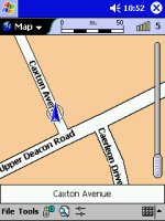
Take a look at the two maps to the left
and compare them with the map on the right (above). The
first is set to a zoom level of 60% and the second set to 100%.
Now if this isn't called
detail, then I don't know what is!
The only thing that SmartPath City
truly lacks is dedicated overlays that show the nearest pub, park,
police station, hotel. |
|
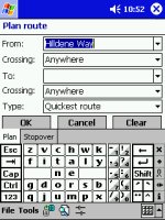
SmartPath City allows you to plan a
route not simply by just tapping on the map (which you can do), but
also by searching street names and locations in it's search screens.
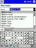
Here you can see in the
first screenshot you can type in the name of the road, all you need is
the first 3-4 characters and it will fill in the rest for you with
intelligent typing, or you can then pull down the combo box to display
everything that starts or is near the characters you typed. |
  |
|
Highs and Low’s
Finally, what is the
software really like to use ? Well it's pretty good. The
worst fact being you have to plan your journey by using either the Trips
or City Maps. Don't think you can
keep both applications open as they will both fight for supremacy over
the GPS receiver, and if you're lucky the one you don't want to use at
that moment in time will be left and the one you wanted will be closed.
In most instances, both applications will be closed.
Apart from this, the only
other downsides is failing to include any voice navigation, map
stitching between city maps. On the other hand, if you haven't
experienced these features in another product, then you won't miss them!
SmartPath Trips and City are very good applications to use, and will
most certainly get you from A to B with the least amount of hassle. |
|
|
 |
 |
 |
 |
|
|


