|
|
 |
 |
 |
 |
|
Review by
Dave Burrows

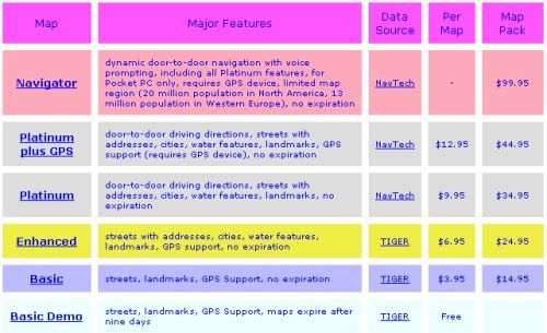
Mapopolis has made a big name
for themselves in the US where they've created a GPS navigation product that is
cheap, affordable for all GPS Users and by keeping the application simple
they've managed to make great strides in features they offer with their
products. This has seen many American users going for Mapopolis because
you only use the maps you require, they're downloadable direct from the
Mapopolis website making updates a breeze, and their support model rivals most
of the top GPS companies offering quick turnarounds on bug fixes and updates.
Mapopolis offer their
Navigation program for free, and you only then pay for the maps you wish to use.
Downloading Mapopolis maps are
easy, once you have created an account on their website and entered your credit
card details, you can download any of the maps under the headings that Mapopolis
provide. The great option here, is Mapopolis give you everything from the
most basic of features, eg Streets, landmarks, GPS Support right up to Navigator
which gives you dynamic door-to-door navigation with voice prompting, including
all Platinum features. This allows you to pick and choose not only the
best maps for your situation, but also the best product set. Not everyone
necessarily requires the full monty, and it's good to see that Mapopolis have
given their customers the option of choosing rather than being dictated to.
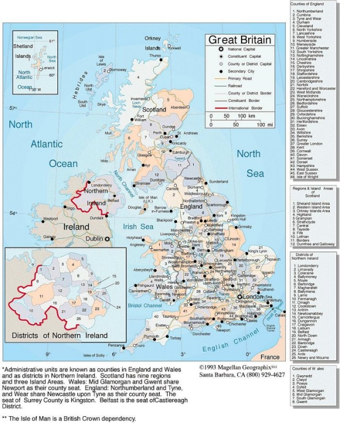
For the purpose of this
review, we have reviewed the FULL UK maps which are listed under the Navigator
product set. When you go to purchase a map set, you'll be given the
opportunity of purchasing each map by country. The complete map pack for
Europe (Release 4) costs $99.95 for a one year usage. If you want to
download singular maps from the Platinum Plus GPS package, you can purchase each
county map at $12.95 per map.
|
|
Mapopolis Navigator v3.18
One thing Mapopolis has attempted
to do is keep things simple. This has paid off in a
number of ways. You don't get confused where any of the options
are within Navigator, it also runs extremely fast, putting it through
the test I have seen no slow downs within the application at all.
Map rotating and zooming is extremely fast, much faster than any other
product on the market today. This maybe partly due to the maps,
although Mapopolis have tried to get as much detail onto the Platinum
maps, they've tried not to go overboard, so roads do look like lines
rather than roads, but this makes the application run very fast and
also gives quicker routing.
As you'll see from the GPS Status screen
below,
everything that's needed eg Speed, Altitude, Heading and Range are
all included with a compass. Mapopolis have also added in a
manual COM port configuration option, and to allow Navigator to
auto-detect your GPS Receiver. This is a feature that should be
added to all GPS products by default, yet we do still find some newer
products on the market not having this feature, so I'm glad to report
that Mapopolis have thought through the most basic of features and
added these to Mapopolis Navigator.
|
Click map to enlarge |
|

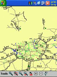
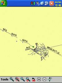
The Map screen again shows great thought. In GPS applications
where we see county or city maps, we've always had the problem of
having to choose between maps, and not be able to map stitch.
Something Mapopolis has achieved is to not only allow for seamless map
stitching, but to also give you the option of selecting multiple maps,
or even better to allow to open all contiguous maps, so if you have one
or more maps, Navigator will open each map when required (and you won't see
this happening it will be accomplished in the background), and the maps will
automatically be stitched together. I think some GPS companies
should take note of what Mapopolis has achieved. Great thought
and design has gone into the product and
many companies could learn from this.
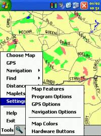
Menus
Within Navigator
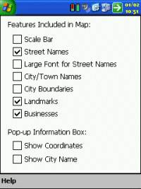
Mapopolis have added a plethora of features. Under Map Features
you'll find options like Scale Bar to display a bar on the map, the
ability to switch on and off Street Names, ability to change the font
from small to large on street names to make it easier to read on-map,
the option to also allow for City/Town Names and Boundaries to be
listed on the maps, and to also include features like Landmarks and
Businesses. You can also within this menu show Coordinates on
screen and the City Name.
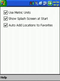
Under Program
Options you'll find options like being able to set units to metric,
showing the splash screen which gives access to the online help within
the program, and to be able to automatically add locations to the
favourite menus which is good because when you have visited a
location, you won't have to manually bookmark it to drive to it again.
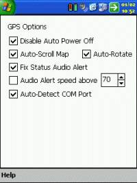
Under the GPS Options you'll see
feaetures like disable Auto Power Off which really is essential when
using navigation products, because if you don't have this feature
selectable, the first thing you'll find when visiting a petrol station
is when you come back to the car that the Pocket PC has turned itself
off, and this can be quite frustrating, thankfully Mapopolis has added
this feature into their product unlike some of the top GPS products!
You also have the ability to have the map auto scroll and to
auto-rotate, or you can have these set to manual (perhaps better for
walking), the ability to have audio alerts above a set speed which can
be used as a speed deterent and to automatically detect the COM port.
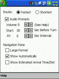
You're starting to get the idea that
Mapopolis Navigator really has been a thought through product and not
just created quickly. Like with many GPS routing products you
also have the option to set the Fastest or Shortest routes. One
thing I think Mapopolis excels with is they actually allow you to set
the audio prompts up, not only what volume can be achieved (1-5), but
also at what intervals Mapopolis will alert you at both from Start
(before turn) and at regular intervals. The Navigator screen
when directions appear will split between directional information and
map, Mapopolis also allows you to configure how large the directional
information is on screen, either in small format, or large format, and
to turn it on and off. Something that most GPS Users request
time and time again is Estimated Time of Arrival information, and
Mapopolis adds this support to Navigator. You can also change
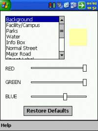
even the smallest of aspect of the mapping by changing colours of the
background, parks, water, streets, major roads, you name it, you can
set the colour, being able to fully customise map colours and utility
information is truly remarkable!
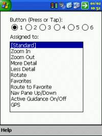
Mapopolis also supports full hardware
button mapping for most of the most commonly used features like Zoom
In and Out, Favourites, etc.
Mapopolis have gone to great lengths and put thought
into every single feature within their product, and this really does
show, and you can see why a lot of American's like the product coupled
with it's low price, really gives value for money.
|
|
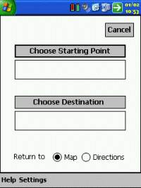
Choosing
your Destination
We've seen a
shift over the past year of going from GPS Navigation programs that
allow you to enter your start and destination locations, to a I'm
here option, now plot my destination. The latter is
something that most people prefer, but you do still sometimes what the
ability of setting a From and To location, and Mapopolis have added
both to Navigator. Something that is clear is Mapopolis are not
forcing their ideas onto you, they're letting you make the decision
which I think is how software should be written. When you go to
choose your Starting Point or Destination a menu will popup allowing
you full select ability on how to plan your route. |
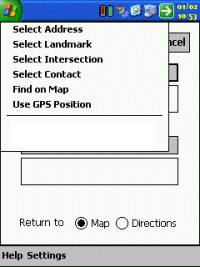 |
| Not only do
you have the option of entering an address, landmark or intersection,
but to also select a contact from your Pocket Outlook Database, and
also to be able to Find an area on the Map or even use your current
GPS Position which is great if you don't know where you currently are!
You'll also see below the section line the full address of each
location you have recently visited (as a favourite), this allows for
quick navigation in the future, and is great if you're using GPS just
between your home and place of work. |
|
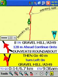
Routing
Once you've
turned on the GPS Driver in the GPS screen, set your Starting Point
and Destination, you can then start driving the map. The route
that Mapopolis Navigator chooses is highlighted in red, when
approaching the next turn, you'll be greeted by one or two directional
information screens. In all of the
tests we threw at Mapopolis Navigator, it always took us to the
destination, although sometimes in strange routes. Mapopolis
seems to have more of a priority to Major A roads rather than Minor A
roads or B or C roads. This results in sometimes Mapopolis
taking you out of your way, sometimes a few miles in the opposite
direction to join a Major A road or Motorway. Once joined it
will take you to your destination, but sometimes you wonder if you
should be putting your faith into the routing of the product.
Going back 4 or 5 years ago prior to using GPS Navigational products,
I would welcome this feature, as I always preferred when map reading
to stick to the Major routes, and I would loath the time when I found
myself driving through the centre of a city knowing that map reading,
navigating and driving at the same time would be difficult at best.
|
 |
|
Since I've
had the pleasure of using many of the top GPS Navigational programs
I've come to put my faith in these more, and I now prefer to be routed
through a town centre if it's going to really be the quickest route.
You can switch Mapopolis to a shortest route scenario for routing,
however some of the quickest routes that have been planned really
aren't the quickest route when you take into consideration you
sometimes have to travel up to 10 miles in the opposite direction of
where you're destination is to join a Major A road. This can be
a little frustrating, and I hope Mapopolis will fine tune it's routing
scenario's to remove Major road routing.
Where
available within the map data you can route to house numbers on
various roads and streets. This makes planning your route all
the more easier giving you reliable departures and destinations.
One good
feature I like when driving using Mapopolis is that when you take a
turn successfully you'll get a little high pitched chime to alert you
that you've made the correct turn. When you make a bad turn, or
go against Mapopolis instructions you will get a low long beep that
signifies you've made an error. This can be very useful when
driving as you're not always able to look at the Pocket PC screen, or
sometimes when you have other passengers in car or the radio on, some
voice commands can get mingled with other noises, so this helps to
re-assure you that you've either made the correct turn, or failed to
make the turn.
 |
|
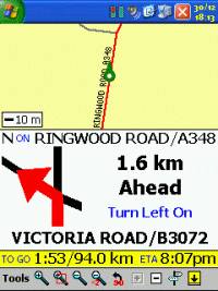
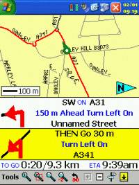
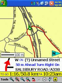
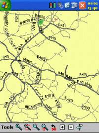
Routing
Around Roundabouts
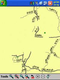
One thing I
found very difficult to navigate using Mapopolis was roundabouts.
Something in England we find roughly at every quarter to half a mile
when you're in a town or city. Mapopolis approach in routing
around roundabouts is to tell you to turn left onto the roundabout,
and rather than drive around the roundabout, they then ask you at the
junction you want to take to take a slight left turn. This
although sounding correct when you say it out allowed, creates
confusion when you're driving. You'll see from the screenshot
right that although the journey is straight on over the roundabout
with a total of 4 exits, Mapopolis Navigator tells you to:-
Unfortunately I found myself having to study the map and look for the
red highlights on the road to determine which exit I should be taking.
|
 |
|
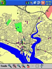
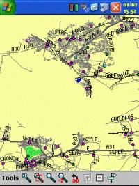
Points Of
Interest
One thing
that we've found Mapopolis does excel on is Points of Interest.
The POI data is part of the maps. Although like all the GPS
products offering Points of Interest, we're still no where near the
complete POI that you'd find in a town, POI is getting better, and
it's nice to see this increasing in every new product that hits the
market.
The Points
Of Interest in Mapopolis will give you the name of the Point Of
Interest and the road or street name that it's on.
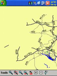
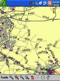
The map to
the right is of Southampton, and you'll see lots of pin circles,
squares and other icons jotted about on the map including
|
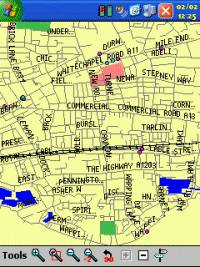
 |
| parks which
are identified by tree's or green areas. All of these allow you
to pull together and use a comprehensive POI database. |
|
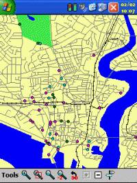 |
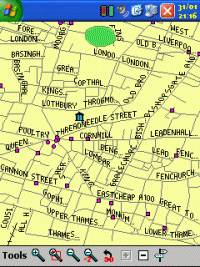
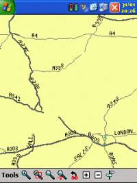
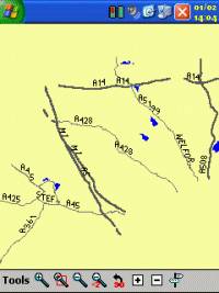
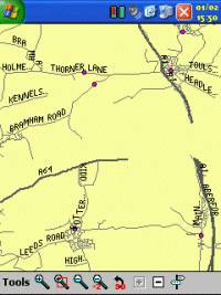
Map
Detail
Another
thing I've always wanted to see is a nice clean and detailed map.
One thing that Mapopolis Navigator provides is this, just take a look
at the screenshot on the left. This is a screenshot of
Southampton City Centre. Above is a screenshot of East Central
London. The amount of detail provided in both these maps, but
especially the left hand map is very impressive!
Looking at
the Southampton City Centre map, I can make out the Common (top left),
the major rail routes into the city, bridges crossing the inlets and
you still get to see the Points of Interest within the City.
|
|
Map
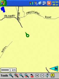
Problems
One problem
we have experienced within Navigator is the map data for the UK. From talking to
various people in the US, maps are very accurate, however in the UK
it's a different story. Mapopolis are
using NavTech as their geodata provider as do other mapping companies
like PowerLOC and Navman. I've spoken with Mapopolis and they
are fully aware of these map problems where huge chunks of map data are
missing from quite a number of maps. Mapopolis are currently
working with NavTech to resolve these issues.
Q. What will
happen if you approach an area of map that has vanished?
A. You will
be routed around this anomaly, unfortunately depending on the diameter
of this anomaly, you may find that you are taken 20 to 30 miles out of
your way to route around this. You can drive through the
anomaly, but you will lose all map data and routing until you come out the other
side where routing will resume as normal.
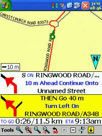
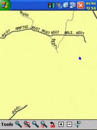
Some of the
mapping problems are only minor with losing a fraction of a mile of
road like in the first screenshot below on both the A40 and A361, but
this can be increased up to two and a half miles, or even a much
larger scale as seen in the third screenshot.
|
|
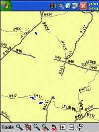
Burford
near Witney, Oxfordshire |
Ringwood,
Hampshire
|
M25,
North West/Central London |
 |
 |
 |
| Essex |
Andover,
Hampshire |
Hampshire and Dorset |
 |
 |
 |
|
Bedfordshire |
Avon |
Northamptonshire |
 |
 |
 |
|
Oxfordshire |
Staffordshire |
Tyne and
Wear |
 |
 |
|
| West
Yorkshire |
Surrey |
|
|
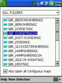
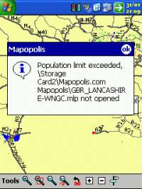
Loading
of Multiple Maps into Memory
One other
problem that we were faced with Mapopolis Navigator, although the
county maps are provided in a single Country download for England,
Wales, Scotland or Northern Island, there are problems if you wanted
to say load the complete UK maps into memory.
This problem
exists when you either select all the maps individually on the Choose Map
screen, or if you open one map and request to open up all contiguous
maps.
With
England, you'll get through just over half of the maps and you will
then be prompted with a dialog error box showing the following message
Population Exceeded error for each map that it cannot add which
can be a little frustrating. |
 |
|
Are there any features not present in
Mapopolis Navigator ?
Mapopolis Navigator does have a vast
amount of features present, but there are some features present in
other products that really would be useful for the GPS user and would
be a great bonus to be added to future versions of Mapopolis Navigator
-
There is no facility to auto-zoom when
close to a junction to make better judgment on which exit or turn to
take which would be very useful
-
No current way to tap and add a location
from the map itself, you have to go through various search options to
add destinations
-
The ability to be able to set a profile
against various colours enabling for day and night colours as most
people find Pocket PC's too bright for night driving and like to
inverse whites with blacks.
-
Currently no SDK is available for third
party developers to be able to add Speed Camera databases and other
POI warning systems.
-
One-way streets aren't currently
supported in Mapopolis Navigator UK maps at present
-
True Track Up feature is definitely
needed with the ability to switch to North Up
|
|
Conclusion
Mapopolis Navigator and maps has great
potential. Most of the features you're looking for in a street
navigation system is present within Mapopolis. Overall the
product scores highly, however some things need to be modified for the
UK and European market like routing around roundabouts, and the
ability to take into consideration routing across towns as quicker
compared to going 10 miles out of the way to join a major road.
One thing unfortunately Mapopolis falls
back on largely is the quality of the maps available for download.
Many of the county maps have roads that suddenly disappear, huge areas
of map data are missing in others, and this will hinder the product in
a UK market unless these are quickly rectified. With this in
mind we do think it should be appropriate for Mapopolis to put a
statement on their website regarding the problems with the UK maps
otherwise this could add even further rejection to the product if
people purchase maps and are unhappy with them. On the other
hand we have already received reports from Mapopolis UK customers who
have been unhappy but have been given grace periods of 30 days to
review the maps and offered a full money back guarantee providing no
more than 5 maps are downloaded when purchasing the complete England
maps. Mapopolis are trying to help their customers which is more
to be said for other GPS companies, and we do thank them for doing the
right thing here.
**Unfortunately due to the expanse of
these map problems we have had to down rate this review as although on
two of the maps used we had only one issue with roads disappearing,
it's unfair to give the review full marks because of what other
Mapopolis customers will experience in the UK. With this in
mind, we would welcome Mapopolis contacting UK users and Pocket GPS
once these map problems have been eliminated and we will re-review the
maps and adjust our review accordingly to re-instate full marks.
|
|
|
 |
 |
 |
 |
|
|