|
|
 |
 |
 |
 |
|
Fugawi GPS Mapping Software for Windows CE devices |
31st October
2002 |
|
|
Fugawi
GPS Mapping Software is similar to OziExplorer: they both
target universal GPS users who need pinpoint positioning both on
and off road. The FugPPC software is provided as part of the Fugawi
PC software package, which retails for $99 USD.
The review package provided
by Fugawi comprised: the PC and CE mapping applications bundled
with European Road Network maps; Europe IV Digital Street Maps $59
USD; and Vancouver - Whistler Digital Topo Maps $66USD
|
 |
|
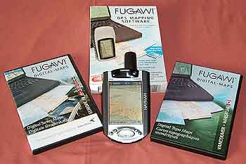
Click on image for larger picture
This review focuses on the FugPPC
application. There is another review which evaluates the Fugawi
PC software. Click here for the PC review.
When deciding if the Fugawi package is suitable for your requirements
you should consider both as a whole solution. Where the CE version
may be marked down it could well be compensated for in the PC application.
Fugawi
is targeted at the Professional and recreational user. This software
is useful for and used world-wide by emergency services, law enforcement,
forestry, geological and mining, palaeontologists, archaeologists,
local council/boroughs, hikers, bikers, off-roaders, sailors, and
pilots, plus many more. FugPPC maps need to be converted using Fugawi.
You have to acquire pre-calibrated maps (selection supplied with
fugawi) or create and calibrate your own maps then download them
to the PPC. Fugawi also provide versions of the software for military
applications. The software is so flexible that you could even use
maps and aerial photographs as provided on many mapping websites (please
check copyright terms and conditions for use before downloading
images).
The
FugPPC software comes bundled with the boxed Fugawi 3 software package,
along with some bonus maps to get you started. This is a commercially
produced application that can be bought from many sources.
The
main features packed into the CE software are:
- Display
of commercial and user created maps.
- Live
display of current position using NMEA 0183 GPS interface
- Display
and logging of track
- Creation
and display of waypoints (positions on your map)
- Display
of route
- Navigation
instructions based on route
- Tight
integration with Fugawi PC
For
the purposes of this review an iPaq 3870 was used with a NavMan
3000 GPS sleeve. This review focuses on the FugPPC software,
another review covers the Fugawi (PC) software. |
|
Software Installation
Installation
is a little unusual in that it is started from within the Fugawi
3 main application. It is a little confusing and the old adage RTM
(Read The Manual) comes into play here.
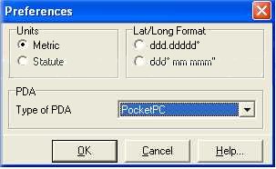
In the settings menu
there is a preferences option. When you click on this you get a
dialog box with your current settings displayed. At the bottom of
this dialogue is a value for Type of PDA. By default this is set
to Palm. Setting this to PocketPC enables the options within the
menus for the PocketPC.
You now need to go to
the Tools where you will find the Install PocketPC Application Files
is now available. When you select this option all the required application
files are loaded on the Pocket PC.
|
 |
|
Creating a
map
There are few maps that you can install and use directly without
using Fugawi PC software, but this is not a problem as long as you
have all the maps you need loaded prior to starting. FugPPC uses
a proprietary map format which compresses the data to enable you
to optimise the usage of your memory.The PC software has a lot of
powerful management features for managing the link between the PC
and the Pocket PC these are referred to as the PDA Library.
There are maps supplied
in the application package which will be relevant to your area,
I was supplied with street maps for Europe but if you live on the
American Continent you will get USA maps. These are automatically
converted into FugPPC format when you use the PDA Library to transfer
them to the Pocket PC.
You can also create
and calibrate your own maps for use in Fugawi. This is covered in
more detail in the Fugawi PC review.
As with other software of this type you can use any map, picture
or graphic to create your map.
|
|
Using the software
When
you start Fugawi an outline map of the World is displayed. If you
previously had a map open then this will be loaded. You can select
to display any map that you have transferred onto your PPC.
|
 |
| Fugawi uses the iPaq
hardware buttons to control some of the features of the application.
These are zooming in and out, and creating a waypoint, and opening
the navigation window. You can also tap and hold to create a waypoint
at specific locations, or tap and drag to move around the map. The
software also has a number of menus to allow you to control it and
set a number of options configuring the way it works. |
|
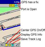 |
There
are also a number of icons on the screen which provide status information,
or allow fast control of the application.
At the top of the screen
there is a strip indicating the current scale of the map, in your
selected units of measurement. A cyan icon displays when you have
a satellite fix, a P in a circle is displayed if the gps unit is
communicating with Fugawi.
At the bottom of the
screen is the menu bar followed by three icons for easy control:
Centre GPS centres the map at the current GPS location; Display
GPS info shows a dialog with the GPS fix information displayed;
and Save Track log.
There is a help file
which explains all the functions of the menus, and the interaction
between Fugawi and FugPPC. The menus are logically arranged in functional
areas, providing easy access to all settings.
|
|
Configuration
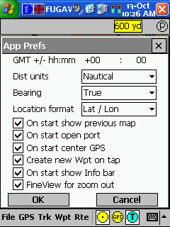
The prefs option from menus is where all the configuration of the
software is done. This is context related to the menu option. The
general operation of FugPPC is defined in the file/prefs dialog.
From this dialog you
can set:
- GMT your current
offset from GMT.
- Distance units can be set to either
Statute (yards and miles), Metric (meters and kilometers), or
Nautical (yards and miles)
- Bearing can be set to either true
or magnetic.
- Location can be displayed either
as Lat/Lon or UTM WGS84 format.
- Show previous map on startup
- Open GPS port on startup
- Centre GPS location on startup
- Create new waypoint when the screen
is tapped.
- Show the info bar on start
- Use fineview when zooming out
|
 |
|
In
Use
The system is really easy to use once you have found your
way around the menus. All you have to do is to ensure that
the map(s) covering the area(s) you are traveling to are loaded
into the PocketPC and off you go. If your startup settings
are configured to automatically start the GPS then as soon
as a fix is obtained your position will be displayed on the
map.
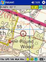
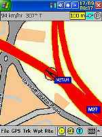
The two screen images show
the maps displayed from different sources. The shot on the
left is a walking track of the Pound Wood in the UK the second
is a driving track from the GMF vector maps supplied with.
The accuracy of the GPS location was within a few meters.
|
 |
 |
|
Reproduced from Ordnance Survey 1: 50,000
mapping
© Crown copyright. All rights
reserved.
|
|
|
At worst the car was shown to be on the wrong side of the road. This
could very well have something to do with the quality of my scanned
maps. |
|
Click on the picture for full size image
|
GPS
Displays
As this is all about integrating Satellite signals with maps
to find your current position a few words about the GPS displays
is in order.
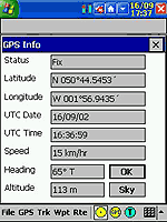
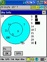
There are two GPS displays,
the first (shown on the left) shows textual data regarding
your position. The co-ordinates will be either Lat/Log or
UTM Northing/Easting. The speed will be either KPH, MPH or
Knots.
The second display (on the
right) shows the "SKY" the positions and relative
signal strength of the visible satellites. |
Click on the picture for full size image
|
|
Waypoints
FugPPC has some powerful waypoint facilities built into the
application. These allow you to configure a number of elements
and features of the waypoint display.
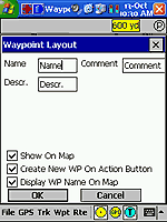
At the top of the waypoint
preferences dialog are three text boxes for Name, Comment and
Description. These can be used to change the way the waypoints
are labeled in the application.
The show on map toggles the
display on the waypoints on the map. Create new WP on action
button will create an waypoint at the current GPS position:
only if you have a GPS fix.
The display WP name on the
map determines if the name of the waypoint is to be displayed.
If not the waypoint will be displayed as a small square.
At significant points on your journey you can set a waypoint
simply by tapping at the point where you can enter the lat/lon co-ordinates of the waypoint
or even easier by pressing the action button to create a waypoint
at the current GPS position. |
Click for full size Image
|
|
This will create a
waypoint with the name P0001 or similar. The details ie name, comments,
description etc can be changed using the edit waypoint facility.
This is highly advisable as you can end up with lots of P0001 waypoints
and it can become a little confusing. Obviously if you are on your
mountain bike hurtling down a hill you wont have time to amend the
details, but you have access to these functions later when you have
stopped. The images below show the
There are options to
load and save and manage the waypoints between FugPPC and Fugawi,
enabling you to create waypoints for specific purposes ie Mountain
Summits, positions of fishing lakes, etc.
|
|
Tracks
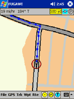
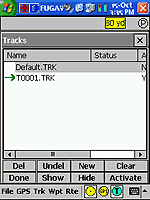
Tracks are essentially a sequence of points that are automatically
recorded to a file, and displayed on the screen in the screen
shots to the right the tracks are shown in dark blue.
In the preferences
you can set the tracks to display either as a series of dots,
or as lines connecting the track points.
As with the waypoints
there is a full management system for your tracks. You can
create new tracks and activate them, you can delete old tracks,
or you can clear tracks you no longer require.
You can also show
and hide the tracks on the map.
|
 |
 |
|
Click
on image for larger picture |
Click image for full size pictures
Reproduced from Ordnance
Survey 1: 50,000 mapping
© Crown copyright. All rights
reserved. |
Routes
and Navigation
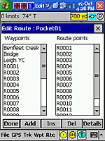
Routes are a series of waypoints linked together. There can
be a number of routes in FugPPC. Routes can also be created
in Fugawi and downloaded into FugPPC.
At the waypoints in the route
you can create a 'Arrival circle' this can be used for a number
of things though primarily for navigation prompting. This
could be used to warn of course changes, or shallows around
coastal regions.
The route management section
allows you to create new routes and then navigate along them.
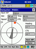
The navigation screen shows
a large compass display with the next waypoint marked on the
circumference. You are shown the Distance, speed, estimated
time of arrival, heading and the course to steer. When you
arrive at the waypoint you can tap on the "Next WP"
button which will then set you up for the next point in the
route.
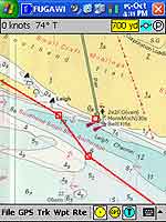
The pictures on the left shows
a route out into the Thames from Leigh-on-Sea round Southend
Pier. This map is a scanned chart of the Thames Estuary and
you can clearly see a fold running down the left hand side
of the display.
The pictures to the right show
the Navigation displays. The top one is where you select your
route and the next waypoint in the route. The lower picture
shows the navigation display indicating the heading and course
to steer.
These routes were created in
Fugawi and then downloaded into FugPPC. Fugawi allows you
to draw the route on the map, which is easier than creating
waypoints at the course changes. I could equally have set
up the waypoints and created the routes in FugPPC
|
Click image for full size pictures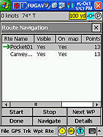
|
|
Maps
As Fugawi is supplied with
maps it is reasonable to review these in relation to their rendering
on FugPPC. See the Fugawi PC review for a review of the maps as
applicable to the PC version.
The maps fall into two
categories Street Level and Topographical. There are also digital
marine charts but these have not been reviewed here.
|
|
The
Street Level maps use data provided by TeleAtlas. These are vector
graphic maps which are converted by Fugawi into raster graphic maps.
The bundled maps provide main road data for Western Europe. The
detail on these maps goes down to major suburb roads,but not residential
roads.
The European IV maps
provide data for the UK (excluding Ireland) and the Scandinavian
countries of Norway, Finland, Sweden, and Denmark. These provide
very detailed street level data which includes all residential roads.
Some examples of these maps have been used throughout the review.
In general they are accurate, but lack detail in terms of road names
and numbers as this data is fixed at the point of export.
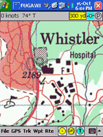
The Digital Topo Map
of Whistler, shown to the right, is a sample of a 1:50,000 DRG topographical
map from the CD. This map is of excellent quality and detail. The
only comment I have is that it is rather large in size transferring
at 11Mb. This would be ideal for anyone hiking off roading or otherwise
exploring this area of Canada.
|
Click image for full size picture
|
|
Strengths and
Weaknesses
As with other applications of this type a major issue is obtaining
or creating maps if you do not live in the right part of the World.
In the USA the government makes digital mapping data freely available.
In the UK and other countries this information is sold at commercial
rates, there is no recreational source of digital raster maps in
the UK for Fugawi that we are aware of or tested. It
is good that the system comes bundled with some 'route' quality
vector graphic maps.
In general the FugPPC
package is full of functionality and has a wealth of useful features,
in particular the integration with the Fugawi and the management
of Waypoints, Routes, and Tracks.
One advantage that FugPPC
has over some of it's rivals is the ability to report in speed in
knots and has a good navigation display showing course to steer.
|
|
Digital Scanning of Maps and
Downloading of Digital Maps Disclaimer
All maps do hold a copyright notice to prohibit the copying of the maps.
Please check the terms and conditions of the copyright and your rights
before digitally scanning any paper maps or downloading of any digital
maps from websites. Most mapping companies
will grant you a license to make at least one copy of the map for
personal use only, however please check first and if requested to do so,
request permission from the copyright holder first before scanning or
downloading the digital maps.
Ordnance Survey Copyright Restrictions
Permission to scan an Ordnance Survey paper map (which is less than 50
years old) for retention on a retrieval system must be requested in
writing stating the purpose of scanning Ordnance Survey maps, scale of
mapping to be used and total area to be scanned in cm squared at
original scale. Permission will not be given if the customer can be
supplied with an equivalent digital mapping product from Ordnance
Survey. A one off data royalty charge will also be applied,
calculated using the number of mapping units scanned, and the customer
must hold a Digital Licence with Ordnance Survey. |
|
|
 |
 |
 |
 |
|
|