|
|
 |
 |
 |
 |
|
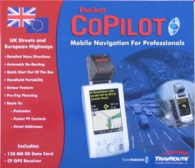
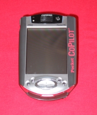
Pocket CoPilot
3.5 UK |
26th November
2002 |
|
|
Review by
Dave Burrows,
Duncan Hill,
Mike Barrett
Travroute is a well
established company in the GPS arena and they have previously had several versions of Navigation software available both for the PC
and Pocket PC, and last year with an alliance with
TeamWarrior in the UK,
brought the Compaq iNS (iPAQ Navigation System) to both Compaq and the UK GPS users.
In the past year,
Travroute have been working very
hard trying to better the current offering both from a hardware aspect and also
to better the current software offering that was available in the Compaq iNS.
Well, when you take a look at CoPilot 3.5UK,
you'll see that they have done just that, and for all you Compaq iNS users out
there, you'll be pleased to see some of the new and enhanced features, and for
those who haven't had the experience of Compaq iNS or CoPilot, then there are
some features that will just make you want to drewl!
|
 |
|
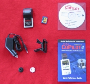
Installation
One thing we all find ourselves doing is ripping
open the packaging, grabbing the CD, inserting it into our CD Rom drive, and
then waiting whilst it takes forever to install a full GPS software package with
country wide maps. This probably is the most depressing part of buying new
GPS systems, and it's usually when I take time to chill out and grab a coffee.
Thankfully Travroute have found this themselves and have not only included the
CD, but they have included a 128mb CF/SD card depending on the package you
purchase. This comes pre-installed with their complete software and maps.
Once you've taken this out of the packaging, you simply insert it into the
Pocket PC, it will start auto-installing the software, and literally in a few
seconds all is complete. No need to spend 30 minutes to an hour trying to
install those large maps finding that your ActiveSync connection dies in the
last minute of copying! This is a superb installation process and really
cannot be flawed in any sense. It's a shame that other companies haven't
chosen to implement this. It does add the cost of a storage card to the
package, but these are coming down in price every week, so really shouldn't
increase the overall price of the product by much. Okay, I now have the
full system installed in less than a couple of minutes, this is impressive and I
was raring to go, although I was deprived of my caffeine shot, however I think the
install process made up for it by a long way and I think the caffeine would
probably make me even more hyperactive!
|
|
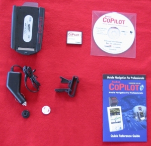
Hardware
There are
currently two hardware offerings available from
TeamWarrior and
Travroute in the
UK.
The first is the standard setup which gives you a Compact Flash GPS Receiver
with an 128mb SD Storage Card which is primarily for use on a Compaq iPAQ
3800/3900 series Pocket PC, or any Pocket PC that will take both an SD and CF
Card at once, and the second one is CoPilot have improved upon the original
Navman sleeve offering and are now offering a new sleeve with an antenna angled
at 45 degrees (or there abouts). This comes supplied with a CF card that
will fit inside the new CoPilot sleeve.
You'll see that both offerings come supplied with
a power cable, a vent mount and a button with double sided sticky tape.
This is to be stuck to your Pocket PC/jacket or the CoPilot sleeve. The
air vent mount acts as a holster and you just slot your Pocket PC into this
effortlessly. One thing that did concern us to start with is that many of
us have gone through mobile phone holders with these button style holders and
they usually break within a few days of heavy use, but so far the CoPilot button looks and feels as though
it's made of very strong plastic, so hopefully this will not be an issue and we
have tested this consistently over a 2 week period.
|
|
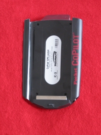
Compact Flash GPS Receiver |
iPAQ NEW Sleeve GPS Receiver |
| |
|
Compact Flash vs Sleeve
Over the past year the Navman sleeve has
become very popular amongst GPS users and GPS companies bundling it
with their current software offerings. The Compact Flash GPS
Receivers are fine, but if you have a Pocket PC and use a Compact
Flash GPS Receiver, then you are limited by which storage mechanism
you can use.
This is where the sleeve's work out
better sometimes with iPAQ's because they have a CF Type II slot allowing for a
storage card giving you the best of both worlds and
enables you to use the GPS receiver in all conditions be it in the
car, out walking and no cables required.
|
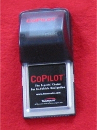
Compact Flash GPS Receiver |
iPAQ NEW Sleeve GPS Receiver |
|
Travroute like many wanted to improve
their current performance and did this by bundling a modified EMTAC
Sleeve. Emtac are the same manufacturers of the
BlueTooth GPS Receiver due to be released shortly world-wide!
Pocket PC users are now getting a great
offering of different receives from in-car GPS mouse, CF Card GPS
Receivers, Compaq iPAQ sleeves and BlueTooth GPS Receivers. This
really is good for the Pocket PC GPS Market!
So which do you prefer ? Do you prefer apples or oranges ?
|
|
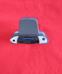
The New CoPilot Sleeve
A closer look at the new CoPilot
sleeve shows it to be very robust and well finished. No sharp
or pointy edges and is a lot slimmer than the previous CoPilot (Navman)
sleeve. You'll also notice a little metal socket top left on
the rear of the sleeve,
this is for the external antenna. Oh yes! You can plug
an external antenna into this baby! At the bottom right of the
sleeve is a DC socket to enable you to plug your charger cable
directly into the sleeve, no need to mess around with that horrible
3800 iPAQ connector cable anymore! The sleeve also comes
with an internal battery. Thought has really been
put into this sleeve.
Several Pocket GPS readers have
commented that the sleeve looks ugly, and there have also been
concern in the GPS user community that having an antenna stick out
at this angle could be a problem if it were to fall and catch on
something in-car.
We can tell you that this antenna is
rock solid, made of very tough plastic, and even if this were to drop, we would hedge
our bets that
the iPAQ would receive more damage than the sleeve antenna! The
antenna may look obtrusive, but when you're walking with it, or have
it in a case on your belt, it really doesn't feel obtrusive. It also doubles up as a good stand
when you put the iPAQ onto your desk ;-).
Seriously though, the sleeve design
makes it as slim as a CF card sleeve, and doesn't skimp on any
features! |
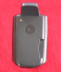
iPAQ NEW Sleeve GPS Receiver
(REAR) |
iPAQ NEW Sleeve GPS Receiver
(TOP) |
|
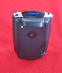
iPAQ NEW Sleeve GPS Receiver
(REAR) |
iPAQ NEW Sleeve GPS Receiver
(FRONT) |
|
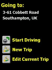
CoPilot Starting your Trip
Travroute have made this a simple
task. As soon as you load CoPilot you are asked for what it
thinks is your next destination. If you only have two
addresses that you've driven to, it will alternate between these,
making it easier to say navigate from home to work and back again.
Once you click on Start Driving
it will start determining your present location, looking for
satellites at your current location. If the destination is
incorrect, you can tap Edit Current Trip and select one of
the other destinations you've driven to. If the location it
thinks you are in is incorrect, you can also change this to
hopefully speed up acquisition times. |
 |
|
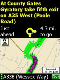
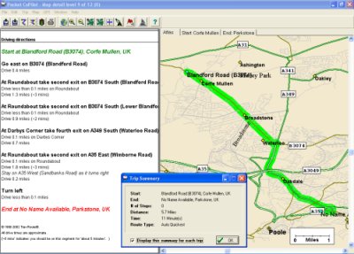
CoPilot Routing
CoPilot 3.5UK contains all the
essential routing options that most of the top packages contain.
Like most Street Routing software for the Pocket PC, you have a
Navigation screen which gives you all the information you require
including the next turn, distance to turn, distance to end of
journey, Estimated Time of Arrival, Street name to arrive at.
You'll notice also it actually shows the full road names, not just
designated A roads, which is a great benefit. When driving
along and getting close to the next turn, the navigation screen
will split into two, the top half giving you the essential
information you require for the next turn on your journey, and the
bottom part of the screen will show your highlighted route in green,
the direction you are travelling and which road you are currently on
designated by the DVR. Although this map screen can be quite
small, it's sometimes better to tap the top half of the screen then
go out to the full size map screen like in fig 3.
You'll also notice your position is designated by a pink chevron.
This moves and plots your course along the road showing where you
are on the road. In fig 3 you'll notice at the
top of these chevrons a pink circle. This is designated
when you are stationary, for example at a roundabout or at traffic
lights, so you always know exactly where you are. The chevrons
can be a little off putting and clutter up the map, especially at
lower zoom levels. Moving around the map is not as intuitive
as other products like Navman SmartST Pro or TomTom Navigator, you
actually have to use the scroll bars which can be kind of difficult
when driving and would advise against attempting this.
|
|
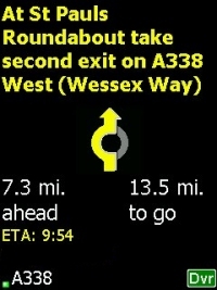
Fig 1 |
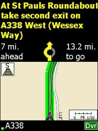
Fig 2 |
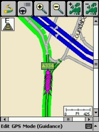
Fig 3 |
|
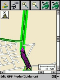
The highlighting of the route is a
similar feature to what you see in AutoRoute on the PC, a better way
to put it is a magic marker highlighting the route. It does
seem to highlight the route by small blocks which allows for sharp
turns in roads as you'll see in fig 4 but it also
makes the route look a little jagged. This isn't a major
issue, just a cosmetic one. You'll see both from fig 4
and fig 5 that the road can get pretty
cluttered up with the driving position pointer. A page should
be taken out of TomTom, Navman and Destinator's books and Travroute
should really change this to a single chevron. Multiple
chevrons makes it easier to quickly pinpoint where you are on the
screen, especially in bad sunlight, however just imaging if you were travelling down some of those
small roads in fig 4 or fig 5, you would have to be zoomed in
to a high level to see where you were driving. |
 |
 |
 |
|
Fig 4 |
Fig 5 |
Fig 6 |
|
Map Problems Found
The maps do seem to be fairly up to
date, certainly more up to date than the maps supplied for the Compaq
iNS. We didn't come across any map errors or impurities whilst
testing CoPilot 3.5UK, however there probably are some out there
judging by map problems found on other competitor products.
Routing
Problems Found
The routing and re-routing is fairly
accurate, we didn't find any problems where we were directed down
strange routes, in fact, comparing it to TomTom, you would think
Travroute were using similar routing algorithms.
GeoData Provider
Travroute are using NavTech as
their Geodata (map) provider.
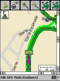
Other Problems Found
We noticed on several stretches of roads
that suddenly the highlighted route would veer off at a tangent for
some reason. No roads covered these areas which seemed strange.
You can see this in Fig 7. This is probably down to the algorithm used, certainly routing was
unaffected by these problems, although the positional pointer did seem
to start to follow the newly highlighted journey, although when the
screen updated/refreshed, it highlighted the correct route, so it was really just a cosmetic issue,
and you weren't suddenly thrown onto a nearby road, so this may be a
minor bug fix that can be applied to resolve this problem.
Before anyone asks, we didn't go driving up or down any motorway
embankments ;-).
|
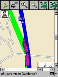
Fig 7 |
|
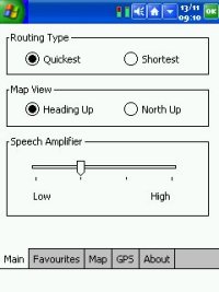
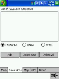
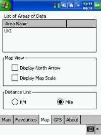
CoPilot Options Screens
The CoPilot Options are full of
features. Like most GPS routing software for the Pocket PC, you
can choose between the Quickest and Shortest Routes
giving you optimum routing abilities. You can also change
the amplification of the Voice Navigation, add and remove favourites,
and list areas of data. Travroute have tried to keep the options
screens as simple as possible. |
 |
|
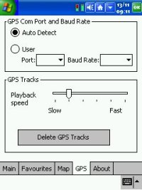
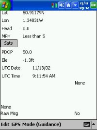
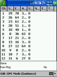
CoPilot GPS Setup Screens
CoPilot like many GPS Applications gives
you the option of using both User selectable COM Ports and Baud Rate
settings, or to AutoDetect these. You also get a GPS Status
screen that gives you most of what you will need to know in terms of
Latitude and Longitude, Heading, Speed, PDOP, Elevation, UTC Date and
time, and further satellite information. If you click on the
SATS button you'll then see a full list of the 12 satellites it can
currently see, and the S column shows how many you have a lock on. |
 |
|
Other Extra Features
In the Map view, you can tap on any
road name and it will display the full road name in big bold letters
(as shown in the screenshot below),
so if you have got lost and you've pulled over and want to quickly
see the road names of surrounding roads, then this can come in very
handy!
You will also notice that roundabouts
have arrows on them and no entry signs to some of the entrances showing you in which direction to travel.
Strangely enough, people do drive the wrong way around roundabouts,
and reverse up slip roads, some people are just completely mad!
This feature will also help if you are in a foreign country and will
help alleviate any fears you have of roundabouts. Also most dual
carriageways when zoomed in will appear as two roads. This can
be good from the point of view for routing, and determining which side
of the road you are on. 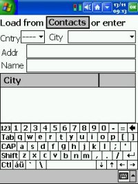 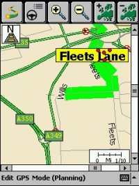 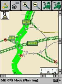
|
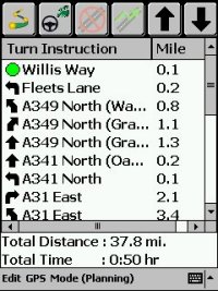 |
Instructions
Instructions is a feature that is widely
implemented in most Pocket PC GPS routing applications, but is rarely used.
I think CoPilot have got this spot on.
What you need on an instruction screen
is exactly what the next turn is, how long in distance to the next
turn, and which direction to make for the turn.
CoPilot gives you all of this with an approximate turn
arrow for each step of your journey.
CoPilot also gives the the total journey
time and distance which is always appreciated on instruction screens.
|
|
CoPilot on the PC
Bundled on the CoPilot CD is a
version of the software that you can run on the PC. This isn't enabled for GPS
use via the PC like the Pocket PC is, but you do get full UK maps and you can plot routes and export
these as smaller maps to the pocket PC.
The PC version gives you three
options to select in transferring data to the Pocket PC.
1) You can export a City Radius which
will allow you to download a specific area around a city of your
choice to the Pocket PC.
2) You can export a Map Area, which
although similar to the City Radius, it allows you to specify any
manually selected area of the map to export to the Pocket PC.
3) The third and final option is to
download data for your specific route. This has the extra
benefit that you will only download a channel of where your route will
take you across the map, saving storage space. By default
CoPilot will select a 10 kilometre radius around all stops and a width
of 10 kilometres on the corridor which connects the start and finish
and any other stops together. The 10 Kilometre is a default, and
can be changed within the the software if you feel that 10 Kilometres
isn't enough. |
  |
|
Voice Navigation
One of the best features by far is the
Voice Navigation which is supplied to Travroute through an agreement
with Fonix. Unlike Voice
Navigation built into other GPS Navigation software, Copilot actually
does speak out the road names rather than (Turn Left or Turn Right).
This really does help when driving, and we found that we very rarely
had to look at the screen. This makes it safer to drive with an
in-car navigation system. CoPilot's Voice Navigation prompts you
will hear are like "After 200 yards, turn right onto Ealing Road".
Although the voice is synthesised, we thought it would be difficult to
get used to, but after listening to CoPilot's Voice Navigation for a
15-20 minute period, we found ourselves well tuned into the way it
speaks and only got caught off guard by the odd road name. The
only downside to the Voice Navigation is that the volume although
quite loud when travelling normal roads, could be louder for motorway
driving. |
|
Re-Routing
Copilot comes with two types of
re-routing, the first is automatic re-routing which occurs when you
fail to continue down the journey CoPilot has mapped out for you, and
the second is manual re-routing in the form of a detour button. Unfortunately when testing CoPilot, we found
ourselves in several very long traffic jams (through no fault of CoPilot, but due to excessive road works and accidents), and
we found the detour button very handy, with a
quick press of the detour button, CoPilot was off and giving us
another route to take. This helped us out on numerous occasions
and worked very well. If you don't like the new alternative
route it's given you, you can press the detour \button again and it
will take you back to the current route. This is a feature that
should be added to all GPS Navigation Software! |
|
Plotting your destination
When plotting your destination, CoPilot
really does excel here as CoPilot really is the only GPS Navigation
software for the Pocket PC that allows you to pick a location by Post
Code. This really does make sense, and is a very quick way of
finding not only the street and city, but also which side of the road
in most cases a building is located on. This really should be a
default option for all Navigation software! CoPilot will also allow you to set
destinations via your Contacts database which is synced with Microsoft
Outlook on your desktop Computer. This makes perfect sense, and
is something that most GPS applications really should support, because
if you're going to want to travel somewhere on business, the chances
are it's listed in your contact database. |
|
Conclusion
CoPilot from a hardware point of view is
good, the CF card has decent enough Time To First Fix's which won't
keep you standing around waiting in the cold or rain, the Sleeve also has
a good TTFF's and is much better than the previous sleeve
offering. The software is very good, modelled on the original
CoPilot software and the software that was supplied in the Compaq iNS
(iPAQ Navigation System), and has been improved upon.
Roundabouts are correctly listed, exits on each roundabout are listed
correctly and the maps appear newer. The Navigation screen has a
wealth of knowledge that will keep most people happy, but when it goes
into split screen mode with a map, the map level detail is difficult
to travel with, and we found ourselves having to drop back into the
Map screen if we wanted to rely on the map. This isn't a fault
in the product, just from how much data you can cram into a half
height screen. CoPilot will also allow you to set destinations
via your Contacts database, which makes entering destinations a
breeze! The Voice Navigation is superb, spelling out each and
every road we needed to travel along, with exit numbers and
directional turn information. It's going to be hard after the
review period not having this information available as it really is a
dream to use, and does make you rely on the screen much less than you
usually would. The only downside with the Voice Navigation, even
with the amplification set to high, it still could have been a little
louder. This was mainly noticed in a very heavy rain storm and
whilst driving along a noisy motorway. |
 |
|
|
 |
 |
 |
 |
|
|


