|
Review by Peter Bailey
WinPilot VFR is a comprehensive planning and in flight information software
package.
The hardware requirement includes a pocketPC ( Ipaq 31/36/37/38/39 or HP Jornada
540), a GPS receiver (NMEA, GPRMC or GPGGA sentences) and a battery power
source. (Unless there is an accessory socket in the plane).
 A world wide
aeronautical database is available as well as vector terrain maps, including
elevation contours, main roads and cities as well as runway diagrams. A world wide
aeronautical database is available as well as vector terrain maps, including
elevation contours, main roads and cities as well as runway diagrams.
The software is all downloadable, at a cost of $299 for a single PDA licence,
and with regular (28day) data updates.(www.WinPilot.com)
The simulator can be downloaded free of charge.
Here is how you can get started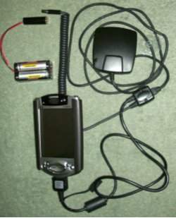
The review kit comprised a Compaq iPAQ 3850, a Leadtek 9531 GPS receiver and a
normal, in-car Y lead adapted to plug into a 5 volt battery power pack.
You will need a similar package.
The VFR software was downloaded together with Europe.wa1 (compressed file of
airspace data), UK.wp3 (UK terrain) and France.wp3. This, plus the password
provided by WinPilot, is all you need to get started.
To start with, place your Pocket PC in the cradle and set up your PC/Pocket PC
Active sync connection, load WinPilot VFR and transfer the ancillary files
to the ‘My Documents’ folder on the PDA. ( For U.K. they only take about 6MB
space).
Now is probably a good time to download the comprehensive instructions and to
study extensively.
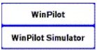
You will
find TWO choices on your PDA program list. Start the Simulator, touch the
MENU button on the top of the screen, goto ABOUT and enter the
password. Next go to FILES and setup the terrain map and
aeronautical information.
The final
setup stage is to exit the simulator, plug in the GPS receiver with battery
power and signal established, go to WinPilot VFR program, select MENU and
COM port and setup the COM port (1) and Baud rate (4800).
You should now be ready to fly.
The package
WinPilot VFR is not just a mapping program but contains all the facilities and
data built in to allow you to plan and execute your most ambitious flights.
 The
simulator program is a good place to start. The map will automatically
centre on the location of your last GPS fix. (Or go to any waypoint location,
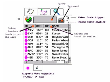
enter and JUMP TO). You can simply go to the WAYPOINTS menu
and select airports, VOR’s and NDB’s from a list starting
nearest to your location. The
simulator program is a good place to start. The map will automatically
centre on the location of your last GPS fix. (Or go to any waypoint location,
enter and JUMP TO). You can simply go to the WAYPOINTS menu
and select airports, VOR’s and NDB’s from a list starting
nearest to your location.
These are designated
by Name, reference, distance and bearing.
(If you need a unique waypoint there is a facility for entering your own and
keeping them on file.)
*** Comprehensive
database and easy to use
(VOR – very high frequency omni-directional radio range
NDB – non directional beacon)
Select
the waypoints in the order of your intended flight, transfer to TASK and
you will end up with a complete flight plan with leg bearing, time
and distance listed and transferred to the map as a track between waypoints.
To get the full benefits of the system you must first setup your aircraft normal
cruising speed, fuel flow, wind speed and direction as well as height units
(ft), speed units (kts) and distance units (nm).
*** accurate and reliable flight planning

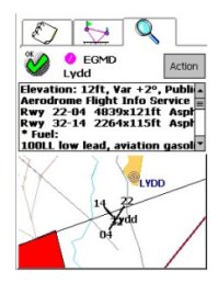
A double tap on any airport or radio beacon shown on the
map pops up a screen of comprehensive information (top right) with radio frequencies,
runway data and, in most cases, a runway diagram.
You can use this data for setting your COMS frequencies, establishing
runway directions and final approach tracks, double checking airport
elevations etc., opening hours and fuel availability.
*** reliable and fairly complete data for all COM, NAV landing en general
requirements
EGMD is Lydd callsign / ID
To zoom out to full Country size or in to runway
level simply use the PDA rocker switch or touch the screen upper right
corner and set the scale.
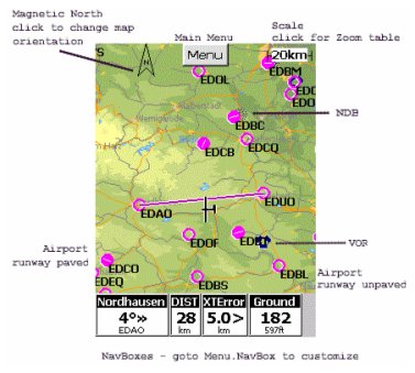 The map
display is quite sparse from the topographical point of view but extremely
clear for getting key information when flying, showing main towns and
geographic features plus ALL airports and radio beacons. The map
display is quite sparse from the topographical point of view but extremely
clear for getting key information when flying, showing main towns and
geographic features plus ALL airports and radio beacons.
One of the main features of the WinPilot VFR is the level of user
selection, (customising), for display and information. This screen
shows deviation from the correct course and distance to the next waypoint
plus ground speed and XT Error (Just how far off track the plane is), but
the display can include wind speed, time, ground level and GPS height.
My approach would be to keep it simple and avoid duplication of the normal
aircraft instruments.
***A simple glance at the screen, in flight, should show the basic
data, (bearing and distance), plus the aircraft diagram relative to course
and waypoint.
 Flying
with WinPilot VFR Flying
with WinPilot VFR
Set up your detailed flight plan, using the simulator before you go to the
plane and double check the aircraft and fuel characteristics that are
entered. Most of the necessary COMS and NAV frequencies are in the
database relating to each waypoint.
You still need to carry a current paper chart and it is good practice to
make a note of the "legs", VOR’s, distances/times and frequencies on your
kneepad. Pencil notation of traffic control instructions, squawk
(transponder) codes, COMS frequencies and air pressure for altimeter
adjustment is still essential.
If the battery pack and hardware is reliable there is no
lack of confidence in WinPilot VFR delivering all that is necessary to get
you to your destination via the planned route. However we still set
our NAV frequencies and use VOR information for course steering as well as
DME for ground speed and distance.
Set up your hardware in the plane, power up and make sure that you have a
GPS fix. (The "live" system needs this to function). Enter wind
speed and direction. (MENU, SETTINGS) and you are ready to go.
WinPilot will automatically compensate for the wind speed and direction in
flight plan and Tracking/ Direction.
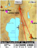
WinPilot will keep you up to date with the moving map indication of
position and course, conveniently zoomed to 10km or 20km, with bearing and
distance to the next waypoint very easy to see.
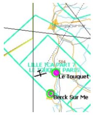
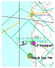
*** For the UK and France maps the coastal definition is a bit difficult
to see, perhaps a pale blue colouring for the sea would help.
I have taken the liberty of illustrating the current map of the coast of
France (below left) together with one retouched with a pale blue sea
(below right).
When approaching a waypoint there is a display indicator
allowing a screen tap to change to the next one.
In flight adjustments
Flying solo needs considerable dexterity, eye to hand co-ordination and
the ability to think about and do 5 things at once. All this and
keeping the heading and height spot on. Talk about issues of
using a mobile phone whilst driving!
Whatever flying aids you may be using can be distracting
and the idea of touching a screen, particularly with a stylus, when a
traffic controller has instructed you to change course is not particularly
welcome. Only experience and regular use will allow the lone pilot
to judge what is practical and safe.
A lot of flying is in company and frequently the "co-pilot" sitting next
to you and linked by headphone is able to assist. The PIC (Pilot in
Charge) can agree how the flying and navigation tasks should be allocated.
WinPilot has been well thought out with the menu buttons and flight plan
instructions easily achieved by finger tip taps. Communication with
the map does, really need the stylus.
Various clever shortcuts have been incorporated which can assist when
plans have to be changed or problems occur.
 The
more familiar you become with the programme the more effective becomes the
solution. The
more familiar you become with the programme the more effective becomes the
solution.
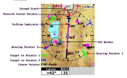
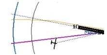
The HSI (Horizontal Situation Indicator)
This map overlay can act as another, easily visible, navigation
instrument.
It can simply superimpose a well defined arrow, pointing to
your next waypoint, in the centre of a compass rose centred on your
current map position.
Probably not a tool for everyone as it can make the screen view more
confusing.
Advanced Features
The ‘engine off emergency’ feature shows all airfields
within gliding distance having a green circle. (I hope we never need it.)
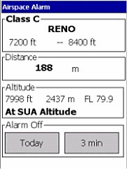
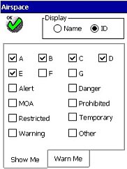
Airspace display and warnings, spoken and visible, can be
custom set and is a very useful feature, particularly when you know that
the information is updated every 28 days. A voice warns of serious
indiscretions and a screen tap is needed to override any warning.
Drag and drop editing allows the stylus to move waypoints
"on the go". Not for the solo pilot but adds flexibility for co-pilot
navigation.
The extended centre-line feature allows you to line up to
the runway in a final approach.
PC planning and transfer to PDA is free if you have a
Windows XP, 2000 or NT system. (this couldn't be tested as we only had a
Windows ME computer available at the time of the review).
 The
test flight The
test flight
I decided to velcro the PDA on a "DiBlasi NavPad" Kneepad,
for security and optimum visibility, and to position the Leadtek by the
front windscreen for best GPS signal. We, (2 of us), used a Piper Warrior
aircraft and there is a convenient door pocket for the battery pack.
We set our course in simulator mode and then settled into the plane.
After connecting up and allowing 2 minutes for the GPS to warm up, we
started the WinPilot, found our location marked on the map and then
entered wind speed and direction.
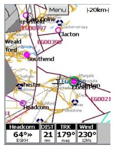
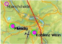
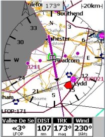
Set for a flight from Headcorn to Rouen (Vallee de Seine) LFOP on a course
of 173 degrees and a distance of 107 nautical miles.
Wind speed of 16Kts from 230deg. Using HIS display.
Watch out for the danger area, marked in red to the west of Lydd and cross
the coast at Rye.
We soon decided to close the HSI to allow a less cluttered screen but
again missed the clear demarcation of a blue sea on the map.
As well as the moving map feature, the groundspeed indicator and distance
to the next waypoint were useful because not all VOR’s have a DME
facility. The bearing indicator (direction of next waypoint) was
also regularly referred to.
On this flight we used WinPilot in conjunction with our VOR
instrumentation with excellent correlation. PDA limitations of
screen glare and brightness were a problem but we could not find a more
suitable screen position in this aircraft.
Whilst this was our first trip, and we lacked familiarity with the
software, we remain of the opinion that it would be quite a handful for a
single pilot. We therefore, kept our procedures as simple as possible and
found the WinPilot navigation experience satisfactory and reliable.
Summary
My flying associates and I were genuinely impressed by this excellent
package. It is well thought out and has evolved with the
participation of regular fliers. Both the information and the way it
is handled will certainly enhance the ease, enjoyment and security of your
flying.
We are still keeping up our other flying skills and intend to use WinPilot
VFR together with RDF etc. and will continue to carry our maps, airport
information, check lists and knee pads.
The mapping detail limitations may be an issue with some flyers but the
display is fine for getting you from A to B with the minimum of
distraction.
For any pilot who already has a suitable PDA and intends to fly regularly
in a variety of aircraft not fitted with GPS the investment in Winpilot
VFR is unlikely to be regretted.
|


