|
|
 |
 |
 |
 |
|
TomTom Navigator European Maps review |
02nd June 2003 |
|
 TomTom need no introduction here. Earlier in March this year TomTom Navigator 2 was released. TomTom kept to their same product packaging as with Navigator 1, this meant that Europe was split into 7 regions. At the same time TomTom also announced what they term as "Navigator 2 Maps of Western Europe". This review looks at these European Maps: what you get and how it all works. TomTom need no introduction here. Earlier in March this year TomTom Navigator 2 was released. TomTom kept to their same product packaging as with Navigator 1, this meant that Europe was split into 7 regions. At the same time TomTom also announced what they term as "Navigator 2 Maps of Western Europe". This review looks at these European Maps: what you get and how it all works.
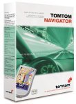 TomTom have set a retail price for the European Maps at €189.00 or about £144.00. TomTom have set a retail price for the European Maps at €189.00 or about £144.00.
The maps are packaged in a large (nearly A4) sized box. Inside this box, like Russian Dolls, is a smaller box which is CD sized and about 2.54cm (that is an inch to you and me) high. This box contains 8 CDs with the maps on.
The first thing I noticed was that there are 7 regions and 8 CDs. Interesting!! I thought that maybe there was something extra in the package. Unfortunately there wasn't. I searched around a bit but could not find any undocumented extras. It may be that TomTom have included some extra map segments that are not on the normal CDs. |
| Pre-requisites
To use these European Maps you need a registered copy of TomTom Navigator 2. The CDs do not contain the Navigator software.
The Maps do not work with TomTom Navigator 1.
Installing the Maps
I noticed when coming to install the maps was that there was no instructions. The only loose documentation is the License Agreement. Looking at all of the text on the boxes, there are details of the minimum configuration, etc, but no installation instructions.
The individual CDs do not help much either. The first CD is called CD1. The second, yes you guessed it, CD2 al the way to CD8.
Not really a big problem being used to the TomTom installer I stuck the first CD in to see what was on it.
The first thing I was asked for was my activation key. After searching through all of the bits and pieces I found it on a sticker under my thumb on the CD box. You only have to enter your key once, the system stores it and doesn't require it again. The activation seems to be the same as for Navigator, but it was completely transparent as I have a permanent Internet connection.
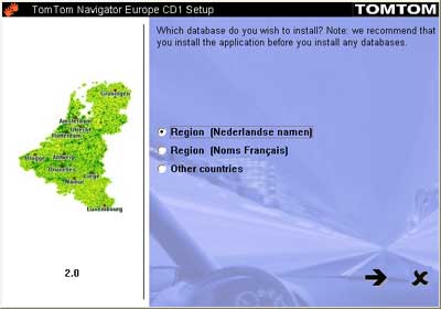 |
Once you have got through the normal license screens you are presented with a map selection screen.
Not surprisingly, I suppose, the default is for Holland. The Dutch maps are available with both Dutch and French place names.
But Holland was not what I was after. I wanted to install Swiss maps. So I clicked on Other countries, which took me to the next screen. |
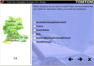 |
The country selection screen shows you the other countries that are on the other disks.
In my case I wanted Switzerland so I selected Austria/Germany/Switzerland and hit the next button.
|
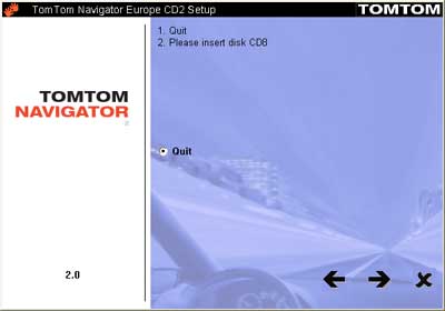 |
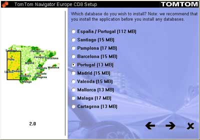
This prompted me to change to the disk containing the appropriate maps for my selection.
In this case it was CD2. (The graphic to the left was when I switched to Portugal later)
Effectively what you have to do is quit the installation, put the new CD in and start all over again. A bit of a nuisance as I would have expected to be able to just switch disks and continue. |
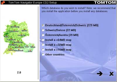 |
Once I had restarted I was then able to select the maps I wanted to install. As I already had some other maps on my storage card I decided to install just a 32Mb map section.
This is done by selecting the 32mb map option and hitting the next button. This takes you to a further screen where you click on the section you want to install.
Interestingly if I had wanted to install a 16Mb segment I would have had to swapped CDs again and put in CD3. |
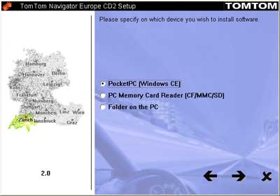 |
Having selected my section of map to install I was then prompted where to install it to.
The good thing here is that you can install to the PDA using ActiveSync, to a Multimedia Card reader on your PC, or to a directory on your computer.
This then goes off and copies all the files to the required location.
|
 |
I was also interested in looking at the Portuguese Maps. I have relations living in a town 20 miles north of Lisbon.
My interest here was to see what the quality of mapping was like in some of the other countries, where GIS is not yet such a major influence.
The fact that the entire country took up 13Mb should be an indication. |
That basically is the installation process. A bit fiddly, but functional. As you would not be using the install all that often it is acceptable. TomTom could smarten it up a bit by making the process seamless and not having to stop and start the installation up to 3 times to install a map, maybe for the next release.
|
|
In Use
OK so having installed the maps how are they used?
Quite simply by ensuring that the maps are available On the storage card, or in main memory, and using the Switch Map menu option. This displays a list of all of the maps available allowing you to select one and continue the Navigator route planning. When you switch maps the program effectively shuts down and restarts again. A bit of a pain for those of us using GPS devices which take a while to initialise, or for iPaq 5450 users where the GPS does not reconnect automatically.
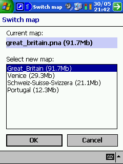 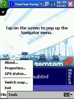
What you cannot do is route between maps. If you live in one map region and regularly travel to an area in another map segment you need to navigate to somewhere on the intersection of the maps and then switch maps and then continue your journey.
One of the most obvious missing maps in the collection is a route map for the entire European Map coverage. I am driving from the UK to Italy next week, and there is no way that I can realistically use TomTom for the entire route. I will be traveling through UK, France, Germany, Switzerland, and Italy which would mean that I need 4 regions, and I would have to guess where the best place to cross the segments would be. This is something that I really would have expected to find in a collection of maps such as this. |
|
Map Quality
The quality of the maps is difficult to judge if you are not familiar with the territory you are viewing. I took some sample snapshots of Italy and Portugal. The Italian maps I was able to compare to a 1:25,000 scale hiking map, whereas the Portuguese map was of an area I know well. What were the like?
Italy
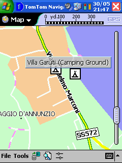
Interestingly the detail for Italy around Lake Garda is extremely accurate. It even has the Campsite that we are visiting as a point of interest. |
Portugal
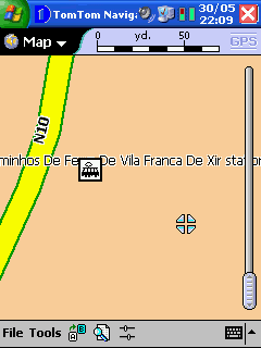
On the other hand the town of Alhandra in Portugal with a population of many thousand people doesn't even have a single road. The find feature of TomTom knows about the town and locates it correctly, but does not have any road detail. |
There has been a lot of discussion about how current and accurate the maps are in our forums. This is on the whole not a TomTom issue but an issue with the data provider. That said once a CD set has been issued it is difficult to update the maps, and unless there are disastrous errors in the maps then they will not be refreshed until the next major release of TomTom. |
|
Conclusion
TomTom have recognised a need for users to have full European Mapping, and addressed this with the release of the full set of maps in a bundle. You will, unfortunately, be paying for one region that you already own, but you will be getting the full set of current maps.
The installation is adequate, it is sometimes a bit fiddly when you need to switch disks.
The main problem is the lack of full Europe routing. If you want to get from one side of Europe to the other it is difficult to achieve with TomTom Navigator. I would have expected that a Major Roads map would have been included in the set to allow drivers to take full advantage of the TomTom Navigator software.
For a complete review of TomTom Navigator, please check out our
review here.
|
|
|
 |
 |
 |
 |
|
|