|
|
 |
 |
 |
 |
|
NAVMAN SmartPath Trips and City (TomTom) for Palm PDA's |
|
|
With SmartPath there are two
kinds of software. To try and stay close to the paper maps and to
keep disk usage to a minimum, two mapping programs were created. One
that gives you an atlas style maps
where you might want to go the length or breadth of the country, and one
that gives you A-Z style street maps for a specific city. The two
mapping programs are called Trips (Atlast) and City (A-Z).
Having the two
types of maps split out, sometimes is quite nice, but does hinder you.
Why does it hinder you ? Okay, let me try to explain. SmartPath Trips is one complete map of the whole of the UK, so you can
load the whole map onto your CF card and you've got the whole country in
Atlas form. If you are travelling from the south to the
north, then in most cases you would want an atlas style map, which Trips
gives you. However, if you
are also travelling through town centres then you will also want a street
atlas. Unfortunately the way SmartPath City is configured is that
you load the maps for a particular town or city and cannot plot journeys
between maps. If you were travelling from south
to north and you wanted to jump to a higher zoom level so you see more
than A or B roads on the City software, then you would have to turn off
the GPS Receiver, close Trips, load City, power on the GPS Receiver, and
then load the city map you are at, find your position and continue on your
way. As you can probably understand, this is a nightmare to navigate
through! Other GPS software are now coming with a single map, but
again because of the detail level.
|
|
|
 |
|
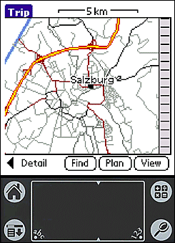
SmartPath Trip is the application of choice when you need to travel from
town to town or city to city.
Because of this, the selection of maps supplied with SmartPath Trip, cover whole
countries. Simply install the desired country on your handheld and you are fully
equipped to navigate to and from any town or city across the entire country.
Countries covered by SmartPath Trip currently include - Austria, Belgium, Czech
Republic & Slovakia, Denmark, Eire, Finland, France, Germany, Greece, Italy,
Luxembourg, Netherlands, Norway, Portugal, Scandinavia, Spain, Sweden,
Switzerland and Mainland U.K. |
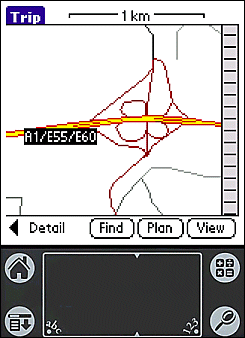
Most maps are supplied in varying
degrees of detail. In this way you are able to carry just the right
amount of detail suitable for your journey, leaving the maximum
amount of memory available in your handheld for your other important
data.
SmartPath Trip also supports multiple maps. If you are touring
Europe, simply install additional maps to cover all of the countries
you plan on visiting. |
|
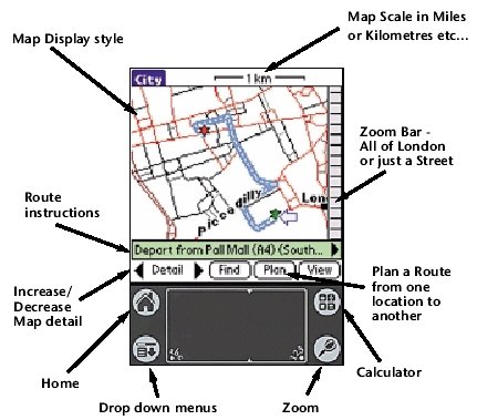
SmartPath
List of Features.
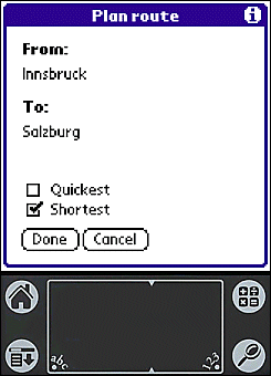
- Route Planning from
Point to Point
- Trip planning from City to City or across City
- Plan quickest route
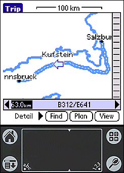
- Turn by turn instructions
- Display Route summary display only option
- Display road names
- Display city names
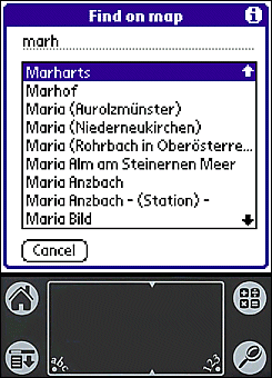
- Go to street/road name
- Go to place name
- Zoom to Route
- Variable map scale
- Clear Route
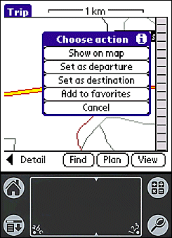
- Store favourite locations
- Metric or Imperial distances
- Map Zoom levels
- Map Detail levels
- "Set cursor as" options e.g. departure
- GPS enabled
- Keep GPS position on screen
- Instructions synchronised with GPS position
|
 |
|
|
 |
 |
 |
 |
|
|