|
|
 |
 |
 |
 |
| Route66 Navigate 7 Street Navigation Software review |
23rd June 2006 |
|
Review by Mike Alder, introduction by Mike Barrett
The name Route 66 conjures up images of driving an open top car across the expanses of America from the East Coast to the West Coast, including one of my favorite drives across the deserts in Arizona...
Route 66 is a full featured navigation system available either as a software only package or full navigation kit including a Bluetooth GPS and car windscreen suction mount.
|
|
Overview
Route 66 Navigation software is available for Europe and more recently the coverage has expanded to USA and Canada so you can now drive Route 66 using Route 66. In the last few months this has been expanded to include the some of: South America; Middle East; South Africa; China and the Asian Pacific.
Using the renowned Navteq mapping data Route 66 provides a full voice guided navigation system complete with POI integration and lane information.
Users can also add their own POIs which allows you to install the PocketGPSWorld.com Speed Camera Database. Soon more loadable POI sets will be available from PocketGPSWorld.com.
|
|
Whats in the Box?
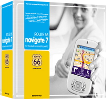
There are 2 different configurations provided with the Route66 Product: Navigation Kit and software only.
The Route66 Navigate 7 product Kit is supplied with the following:
- Memory card (miniSD) + adapter (SD)
- Navigation software, geographic map and user manual (CD)
- Memory card reader/writer
- Bluetooth GPS receiver (SiRF Star III)
- In-car charger cable for GPS receiver
- ROUTE 66 lanyard
- Quick Start Guide
- Professional car mount for your Pocket PC
- Pocket PC NOT included in this pack
|
Specifications and Compatibility
The following is an extract from the Route66 site:
Your Pocket PC must have the following specifications:
- A free slot for an extra memory card
- Windows Mobile 2003 operating system or higher
- 16 MB free runtime memory
- Optional: a GPRS internet connection to access up-to-date traffic information (only in case of Windows Mobile for Pocket PC Phone Edition)
- You must have a PC with a USB port, a memory card reader/writer, a memory card (256 MB) and a (wired, Bluetooth, Compact Flash or built-in) GPS receiver to use this product
There is a list of supported PDAs that the software is compatible with on the Route66 website. Obviously if you are considering the Route66 Navigation Kit your PDA must have bluetooth capabilities.
|
The Route66 Navigate 7 review
This review was compiled using the software only version of the Route66 Navigate 7 product. It is identical in all aspects to the Route66 Navigate 7 Kit with the exception that the initial installation needs to be performed manually. The Kit comes with a pre-installed SD card.
Installation from the supplied CD requires access to a card reader, part of the installation will format the memory card so make sure there is nothing stored on it that might be later required.
Once completed the memory card is inserted to the Pocket PC (in this case an Imate-PDA-N, with integral SiRF-III GPS receiver), the application starts to load to the device, then automatically starts.
Once up and running you are presented with the activation screen, If you have an internet connection available this is easy to complete by following the on screen prompts, if not simply tap the “Activate Later” option and start to use the navigation software, active the product when it is convenient for yourself. You can activate the license on a second device after seven days and a third device 28 days after the second, although you must only use the software on a single device at any one time to remain within the license agreement. |
|
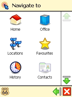
One real bonus was the GPS device being found instantly, no messing around configuring ports/ speeds etc. Some basic set-up is required such as the time (auto update from GPS), unit of measurement kph/ mph, set the home location, and the office location.
This second favourite (or least favourite depending on how much you enjoy your job) is a welcome addition, it makes it very easy to configure for the two most frequent destinations, although finding the locations isn’t too easy, only five digit postcode support is available.
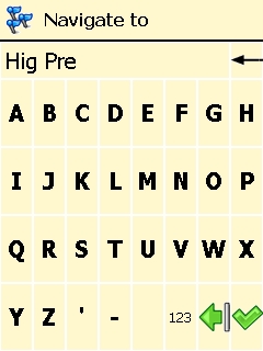
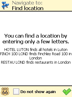
The ability to “speed text” the location search is quite good in use, it just takes a little getting used to, for example “Highgate Lane, Warton nr Preston can be found by entering “hig pre” |
 |
 |
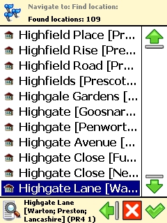 |
A list is presented of search results where your location will be found, if its not there try another entry such as “hig war”.
Once you get used to it, it’s not too bad, just different although I would prefer true seven digit postcode support, in this example above you can see the software has returned 109 finds, the actual location I wanted was on the third page, when you select each one a small text box at the bottom of the screen gives the full location of each result, you then hit the green tick to calculate the route to this location.
The easiest way I have found of navigating and setting the destination is by using the Navigate to “POI around Position”, or “POI around destination”.
(Please bear in mind this is for the Pocket PC version of the software, not the SmartPhone edition – which I have been informed is difficult to use in this way).
|
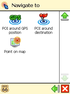 |
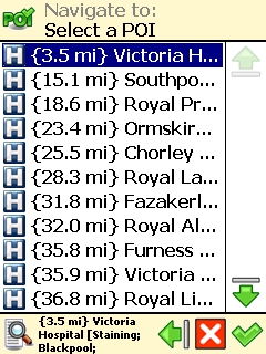
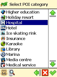
As a simple example to go to my local Hospital, first tap the “POI around GPS Position” then scroll through the list of installed POI, (custom POI’s are also listed where loaded by the user), and select Hospital, the next screen lists all the Hospitals presented in nearest to current location, sorted by distance, in my case select Victoria Hospital.
This may appear long winded but in practice it takes a matter of seconds, also bearing in mind the huge and diverse POI categories to chose from, I am not going to bother listing them all, but there are 84 specific POI’s pre-loaded, and you have the option to add your own custom ones or create your own from scratch.
|
 |
One other “Navigate to” option is History i.e. a recent destination log, this again is well equipped as you can delete single line items or the entire list at the tap of the screen. It often amazes me how often we get asked “how do I clear my recent destinations from the device”, with this application the tool set is provided , empowering the user to wipe out where they have been, my only thought on this is why?, what are they trying to hide!
Also included is Navigate to Favourites, these locations have to be created, but it simplifies the regular trips.
Clever use of the above options goes quite some way to overcome the clumsy “Navigate to locations” and the missing full postcode support, as I said earlier it really is different. |
 |
In use I have found the Navigation Routing fairly good, the two next prompts being clearly displayed – a nice touch as at a glance you can tell what’s coming next and immediately after, very useful when driving in cities allowing for early lane selections to be made where required.
|
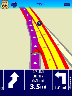
The screen shot on the left indicates Bear Right in 3.5 Miles, followed by a turn left 1,0 miles after the Bear Right. |
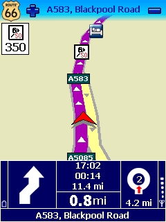
The screen shot on the Right indicates Bear Right in 0,8 Miles, followed by a second exit at the roundabout a further 4,2 Miles after the Bear Right. |
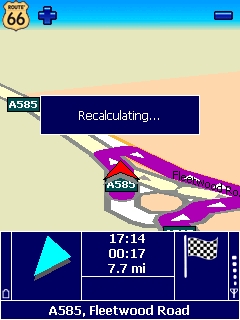
One thing I do miss from the display that really should be present is current speed, its one of the few faults I can find with the human interface of the software, also if you decide to ignore the guidance offered, you will quickly get fed up of the audio prompt “Make a U Turn” as it takes what seems like an age for the software to actually re-calculate a new route, it hangs on to the original route for far too long.
I recently used it from Ashford in Kent to my home town of Blackpool Lancashire, on the run back I decided to go a different route to that the unit offered, the persistent nagging to “Turn Around” continued for over two hundred miles. It appeared the unit wanted to go past a specific location on the M25 (I had not set any Via options etc). It kept me amused for the three hundred mile trip, in the end I had to exit the M6 (it was closed again) and this provoked the true re-calculation, I was less than 40 miles from home at this point – not very good. If you do find yourself in the position of not following the original route, after say five miles tap the screen and re-enter your destination, this will clear the problem, and stop the incessant nagging to turn around – I turned the volume off on this occasion.
|
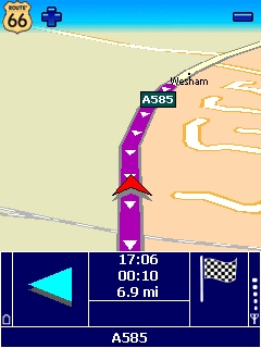 |
While discussing the screen colours I should mention the refresh rate, very smooth and progressive movement, one of the better packages I have seen in a while, although it does slow down if you try using it on a VGA equipped device, QVGA is great though, also the device hardware I am trying the application out with is only equipped with a 300MHz processor, certainly not the fastest machine on the market, but if the application works on this device (and it does) it should perform well on practically anything.
In use the screen colours contrast is excellent, and supplied is a way to change any of the colours you require within the application no recourse to a PC is needed, another nice touch, although the supplied colours of the display are excellent as they are.
The voice is also very clear and easy to understand, as always with any sat nav product the voice guidance needs to be combined with the on screen display showing the distance to turns/ maneuvers etc but the last turn instruction generated by Route 66 is usually on top of the junction, very good predictive timing for this alert.
|
 |
In use my only criticism is the user interface for entering destinations, it just doesn’t feel quite right, in fairness though it gets easier the more you use it, once on the road it’s a great application. I have so far encountered a couple of strange routes, on one occasion the device navigated me around the block only to return to my original route from which point it went straight on, the unit does this same trick every morning on my way to work, bizarre behavior. The second route anomaly added 3 miles to journey, I followed the device out of curiosity, if you didn’t know where you are the device will still get you to the destination, but I am not too sure on its ability to navigate the optimum route. In towns/ cities etc the navigation is spot on picking out routes through housing estates with ease, rather than sticking to the primary roads, the only problems I have encountered have both been out in the countryside.
|
Points Of Interest (POI)
Installed is a comprehensive array of POI including usable telephone numbers in certain cases, you can also add your own (csv file format, and 22x22 bitmaps for the icons).
The inbuilt POI have excellent graphics with a 3d like appearance.
POI warnings are also available, to use a custom sound the alert must be in the .OGG file format, One thing I did like when setting up the POI warnings is the ability to tick as many POI as you like then apply the warning settings to the group, far easier than each one at a time.
A concern is that using the “Warn only if POI on route” is checked it really does mean this, if the camera is offset slightly (quite a few mobiles around where I live are on parallel adjacent roads), it will not warn of the location, turn off the check box and the alerts are fine.
|
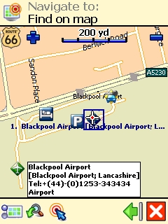 |
Another thing with the POI Warner, if more than a single POI are in range of your position, you will get the alert, audio and the countdown to the first POI, but you will not receive a second warning of the next POI until the first POI has been cleared, this is only a problem where multiple cameras are located in the same vicinity (you try driving around Blackpool, the devices are everywhere, this screen capture does show off the PocketGPSWorld database successfully loaded on to the Route 66 software and working though).
If you do use the Warn only if POI on Route option, and then drive around without a route planned you still get warnings, the software automatically reverts to warning – a very nice and useful touch.
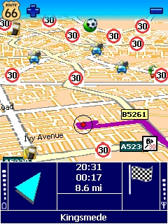
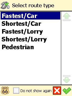
Setting the device up for navigation you are presented with quite a number of screens to tap your way through before getting the Navigation up and running, however the code writers have included options for “Do Not Show Again” on a number of repetitive screens, once selected this reduces the menu clutter, and speeds up the process of getting the device working in the manor you require. There is still the ability to bring back these additional screens if at some point you change your mind on the entered settings.
|
 |
Customisations
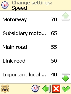
Route 66 also allows you to customise the speed of the road types, sadly all it seems to do is alter the ETA calculation, I have tried various settings and routes, but each time I am offered the same route irrespective of the road speeds that I choose, it’s a shame the set speeds cannot influence the route.
There are other settings for route calculation including HGV support, but as I don’t drive one I cannot really comment on how effective this option is when put to use, perhaps Alix776 can comment if I lend him the kit for a week?
TMC (Traffic Message Channel) is also supported, and you have the option to select dynamic re-routing to avoid the trouble spots, I have little experience of using this service as I have a hatred of GPRS connection fees, this has recently arisen having been stung for £95 last month for GPRS traffic alone on one of my devices – My fault entirely but once bitten etc. |
 |
 |
 |
| Conclusions
The Navigate to interface could be improved, the logic just doesn’t feel right, the lack of full UK postcode support is a hindrance, and I would like to see the vehicles current speed on the main display, these faults aside the application is a great addition to the world of sat nav, I can honestly say I prefer the display when in use to any of the other products I own.
|
|
|
|
 |
 |
 |
 |
|
|