Hi! We see you’re using an ad-blocker. We’re fine with that and won’t stop you visiting the site.
But as we’re losing ad-revenue from this then why not make a donation towards website running costs?. Or you could disable your ad-blocker for this site. We think you’ll find our adverts are not overbearing!
Joined: 20/08/2002 11:51:57 Posts: 3859 Location: Essex, UK
Posted: Wed Sep 01, 2004 12:51 pm Post subject: Fugawi release new version of UK mapping software
Fugawi have just released Version 2 of the Fugawi UK mapping software.
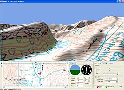
Version 2 includes new features including 3d mapping representation on the PC with 3d Fly through.
Also available for the first time from Fugawi is Fugawi SkyView UK. This is a set of aerial photography images from Getmapping which can be displayed in 3d mode.
Cost for Fugawi UK V2 is £50 per region while SkyView is £70 per region. There is a special Upgrade price available until December 31 2004. _________________ Mike Barrett
Joined: 11/07/2002 14:36:40 Posts: 23848 Location: Hampshire, UK
Posted: Wed Sep 01, 2004 8:40 pm Post subject:
The full text of the PRESS Release follows:
New FUGAWI software products bring UK maps to life
Toronto September 1, 2004 World famous FUGAWI announced today the release of three new map-based software products. These products, designed for outdoor pursuits such as walking and cycling, include:
FUGAWI UK Digital Maps Version 2, FUGAWI SkyView UK and FUGAWI UK Digital Streets.
FUGAWI UK Digital Maps Version 2, which delivers the fabulous UK Ordnance Survey® Landranger® maps to the home computer, builds on the success of Version 1 by combining updated 2004 map data with a new and astounding 3D map visualization, an optional vector street map overlay and enhanced elevation data.
With FUGAWI UK Digital Maps Version 2, one can view roads, footpaths, woods, water features, important buildings, historic sites and height contours right on a PC either in traditional 2D map-mode or new enhanced 3D-mode.
FUGAWI UK Digital Maps Version 2 is supplied with software for PC as well as software for Microsoft® Pocket PC and Palm OS. Included are all 1:50,000 scale Ordnance Survey® Landranger® maps for the region purchased (four regions make up all of Great Britain); complete 1:250,000 scale topographic mapping and a Miniscale map of all of Great Britain; a detailed digital gazetteer of place names; and
enhanced resolution height data.
FUGAWI SkyView UK contains all of the features of FUGAWI UK Digital Maps Version 2 but contains fabulous colour air photography from Getmapping® instead of Ordnance Survey® topo maps. FUGAWI SkyView UK provides a fascinating map accurate view of the terrain from the sky, either in flat 2D map mode or in new enhanced 3D mode. FUGAWI SkyView UK and FUGAWI UK Digital Maps Version 2 are fully compatible, allowing one who owns both products to view detailed topographic maps and air photo maps simultaneously.
Further, a user can connect a laptop computer to almost any popular handheld GPS for the ultimate in moving-map navigation across these amazingly detailed maps again, either in traditional 2D map mode or new enhanced 3D mode. One can even upload and download waypoints, routes, and tracks between FUGAWI and almost all popular handheld GPS. Better yet, download maps to a handheld computer (running either Palm OS or Microsoft® Pocket PC), connect one of many available GPS units and one has a handheld moving-map display.
Add the optional FUGAWI UK Digital Streets module to either FUGAWI UK Digital Maps Version 2 or FUGAWI SkyView UK and see all of the streets of Great Britain, searchable by street name as an overlay on top of the maps or air photos.
FUGAWI UK Digital Maps Version 2 is available in 4 regions. The four regions combined cover all of Great Britain. FUGAWI SkyView UK is available in 4 regions which combined cover all of England and Wales. FUGAWI UK Digital Streets is available as one region, covering all of Great Britain.
Joined: 11/10/2002 06:31:24 Posts: 98 Location: United Kingdom
Posted: Tue Sep 07, 2004 6:02 am Post subject:
What a stunningly generous ugrade offer - NOT!
I was hoping that the new version might actually be usable. Looks like I'll never find out now - because there's no way I'm paying full-whack for a bug-fix.
Joined: 29/08/2002 20:50:29 Posts: 53 Location: United Kingdom
Posted: Sat Sep 11, 2004 9:17 pm Post subject: Has anyone got any of these programs?
Has anyone got any of these programs? I think Fugawi version 1 was very good value for money. I must admit that it does seem that a mere £10 refund for upgrading to version 2 is poor but what about the Skyview programs - these do look exciting and reasonable pricewise.
does this version allow map loading directly to an SD card in a writer attached to the PC or does it still only work via Active Sync.? Also, does it support OS Grid References on the PPC. ?
No, Fugawi 2 does NOT support OSGB grid references on the PPC (only Lat/Long degrees and UTM); a disgraceful situation as it's a product intended specifically for the UK :-(
Posted: Today Post subject: Pocket GPS Advertising
We see you’re using an ad-blocker. We’re fine with that and won’t stop you visiting the site.
Have you considered making a donation towards website running costs?. Or you could disable your ad-blocker for this site. We think you’ll find our adverts are not overbearing!
You cannot post new topics in this forum You cannot reply to topics in this forum You cannot edit your posts in this forum You cannot delete your posts in this forum You cannot vote in polls in this forum
Or you could disable your ad-blocker for this site. We think you’ll find our adverts are not overbearing!
Hi! We see you’re using an ad-blocker. We’re fine with that and won’t stop you visiting the site.
But as we’re losing ad-revenue from this then why not make a donation towards website running costs?. Or you could disable your ad-blocker for this site. We think you’ll find our adverts are not overbearing!


 Fugawi have just released Version 2 of the Fugawi UK mapping software.


