| View previous topic :: View next topic |
| Author |
Message |
MaFt
Pocket GPS Staff


Joined: Aug 31, 2005
Posts: 15392
Location: Bradford, West Yorkshire
|
 Posted: Tue Aug 18, 2009 1:20 pm Post subject: OpenStreetMap Data Now Available on Submission Maps Posted: Tue Aug 18, 2009 1:20 pm Post subject: OpenStreetMap Data Now Available on Submission Maps |
 |
|
 Here at PocketGPSWorld Towers we like OpenStreetMap (OSM). The speed at which the map tiles get updated is staggering when you consider how long it can take for TeleAtlas and NavTeq to update their maps with new road layouts. The open source nature of the OSM project also makes it easy for anyone to update the data, add new roads, correct existing roads and even mark the location of traffic lights and mini-roundabouts. Looking closer to home, our submission map currently uses Google Maps which in some countries doesn't have the required road detail for adding POIs and speed camera locations. We have been beavering away behind the scenes and have now added OSM as a new map view on both of our submission maps. This will hopefully make it easier to add cameras to new roads and also for the countries where Google Maps just doesn't quite cut it. And remember, if the road you need isn't on either map then head over to OpenStreetMap.org, add it, and in a few days it'll show on the submission map! Here at PocketGPSWorld Towers we like OpenStreetMap (OSM). The speed at which the map tiles get updated is staggering when you consider how long it can take for TeleAtlas and NavTeq to update their maps with new road layouts. The open source nature of the OSM project also makes it easy for anyone to update the data, add new roads, correct existing roads and even mark the location of traffic lights and mini-roundabouts. Looking closer to home, our submission map currently uses Google Maps which in some countries doesn't have the required road detail for adding POIs and speed camera locations. We have been beavering away behind the scenes and have now added OSM as a new map view on both of our submission maps. This will hopefully make it easier to add cameras to new roads and also for the countries where Google Maps just doesn't quite cut it. And remember, if the road you need isn't on either map then head over to OpenStreetMap.org, add it, and in a few days it'll show on the submission map!
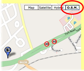
To use the OpenStreetMap view simply press the 'O.S.M.' button at the top right of the submission map.
 |
|
| Back to top |
|
 |
worried
Lifetime Member

Joined: Mar 02, 2006
Posts: 74
|
| Posted: Tue Aug 18, 2009 2:53 pm Post subject: |
|
|
Well I have lived in this house for 45 years and the road isnt marked, however a road built two years ago is marked.
That no good to man nor beast |
|
| Back to top |
|
|
worried
Lifetime Member
Joined: Mar 02, 2006
Posts: 74
|
| Posted: Tue Aug 18, 2009 3:01 pm Post subject: |
|
|
OSM map

Google Map
 |
|
| Back to top |
|
|
MaFt
Pocket GPS Staff
Joined: Aug 31, 2005
Posts: 15392
Location: Bradford, West Yorkshire
|
| Posted: Tue Aug 18, 2009 4:10 pm Post subject: |
|
|
take a look at: 43.889480,25.964126 (it's in Romania - we have speed camera data there too)
then zoom out 5 or 6 levels.
which is more useful now?
MaFt |
|
| Back to top |
|
|
Darren
Frequent Visitor

Joined: 11/07/2002 14:36:40
Posts: 23848
Location: Hampshire, UK
|
| Posted: Tue Aug 18, 2009 4:11 pm Post subject: |
|
|
Clearly you don't know what OpenStreetMap is!
OpenStreetmap or OSM as it's known is a community effort to log road data and create a FREE open source digital map. Volunteers log roads and map their local areas and add to the master map which is then made available to all the applications that can use the data.
Until YOU or someone else in your locality adds it then it never will get added.
More info here.
So now you know you've no excuse, get out there, log the roads and add them and in a few days they will appear on the map. It may appear daunting at first but it isn't so hard and is great fun.
_________________
Darren Griffin |
|
| Back to top |
|
|
worried
Lifetime Member
Joined: Mar 02, 2006
Posts: 74
|
| Posted: Tue Aug 18, 2009 4:23 pm Post subject: |
|
|
It would take me a few month to log all the missed roads in Braintree.
By logging them do we have to plot the actual route or just draw a straight line like Challis Lane on my maps above. |
|
| Back to top |
|
|
Darren
Frequent Visitor
Joined: 11/07/2002 14:36:40
Posts: 23848
Location: Hampshire, UK
|
| Posted: Tue Aug 18, 2009 4:31 pm Post subject: |
|
|
You have to go out with a GPS logger or software capable of logging and drive the roads.
If we all did even a few roads it would help. I've filled in a lot of huge gaps in my home town and as MaFt has shown, in some countries the OSM data is much better than any other map provider.
You don't have to of course but if you don't, then you aren't allowed to moan about missing roads 
_________________
Darren Griffin |
|
| Back to top |
|
|
GerryC
Pocket GPS Moderator


Joined: Mar 01, 2005
Posts: 1513
Location: West Mids
|
| Posted: Tue Aug 18, 2009 4:33 pm Post subject: |
|
|
Personally, I'd say to get it on there as best you can. If the road is straight then just the two points may be enough. If it's curved then make it with more points.
You, or someone else, can come back later and refine it if necessary.
_________________
Gerry
TomTom730T
Cameralert for Android
Brodit ProClip mount |
|
| Back to top |
|
|
MaFt
Pocket GPS Staff
Joined: Aug 31, 2005
Posts: 15392
Location: Bradford, West Yorkshire
|
| Posted: Wed Aug 19, 2009 12:30 am Post subject: |
|
|
another example of OSM 'winning' over teleatlas is just above MOBILE:38737@30
in google maps Bramble Way, Rose Crescent and Highlands Park are all missing, but looking on satellite view you can see that it is a new estate so you may be forgiven for their lack of update.
but wait, head over to OSM and the roads are there...!
yes, ok, it has it's shortfalls (as you mentioned above) but the speed of updates once the data is submitted is incredibly fast. i don't think it will be relatively long until we start seeing devices that are running on OSM for the majority of routes. and if it doesn't happen then at least i've had fun and we have a freely available map with pois, streets, footpaths, bridleways, powerlines and trig points without any fees to pay!
MaFt |
|
| Back to top |
|
|
DennisN
Tired Old Man

Joined: Feb 27, 2006
Posts: 14907
Location: Keynsham
|
| Posted: Wed Aug 19, 2009 12:54 am Post subject: |
|
|
I don't suppose we can get that onto my TomTom to take to Corfu next week? It's got my holiday village on (and rather importantly, the road to it!).
What's a GPS logger or software capable of logging?
_________________
Dennis
If it tastes good - it's fattening.
Two of them are obesiting!! |
|
| Back to top |
|
|
mikealder
Pocket GPS Moderator

Joined: Jan 14, 2005
Posts: 19638
Location: Blackpool , Lancs
|
| Posted: Wed Aug 19, 2009 7:53 am Post subject: |
|
|
It is possible to take a series of different pictures from the open street map and load them to a TomTom, but it would take some considerable time to get it right, there are loads of details on how to do this Here
A GPS logger can receive the GPS signal and record it on its internal memory or memory card. If you want to log where you have been using your TomTom then you can add something like NMEA Logger to the device see Here - Mike |
|
| Back to top |
|
|
AliOnHols
Pocket GPS Verifier


Joined: Oct 15, 2008
Posts: 1942
|
| Posted: Wed Aug 19, 2009 7:56 am Post subject: |
|
|
| DennisN wrote: | I don't suppose we can get that onto my TomTom to take to Corfu next week? It's got my holiday village on (and rather importantly, the road to it!).
What's a GPS logger or software capable of logging? |
Hi DennisN. A trip logger is a device which is capable of saving positions or a route where you have been by storing the gps data which you can then review later.
Logging software is software you can install on to your SatNav to enable it to perform this function. For TomTom, possible software is created by Rousillat and is available on his Le Web Bazar web site at http://www.webazar.org/tomtom/plugins.php?lang=uk
Look at "Tripmaster" and "nmealogger" for example.
Regards
EDIT - Logging software names added.
_________________
Garmin Nuvi 2599
Android with CamerAlert, OsmAnd+, Waze & TT Europe.
TomTom GO 730, GO 930, GO 940 & Rider2.
SatMap Active 10 & 20.
Last edited by AliOnHols on Wed Aug 19, 2009 8:06 am; edited 1 time in total |
|
| Back to top |
|
|
h5djr
Lifetime Member

Joined: Feb 25, 2005
Posts: 228
Location: St Neots Cambs UK
|
| Posted: Wed Aug 19, 2009 7:56 am Post subject: |
|
|
The road where I live is called Elizabeth Court in Eaton Socon and is not shown on the maps. These 20 houses were built 30 years ago.
_________________
Dave R (h5djr)
TomTom XL + Audi A3 (with navigation) |
|
| Back to top |
|
|
mikealder
Pocket GPS Moderator
Joined: Jan 14, 2005
Posts: 19638
Location: Blackpool , Lancs
|
| Posted: Wed Aug 19, 2009 7:59 am Post subject: |
|
|
| As has already been mentioned, if you find the road isn't on the map its no good complaining about it simply add the road to the map yourself. Its dead easy to do, the only issue is that once you start mapping it tends to get addictive! - Mike |
|
| Back to top |
|
|
Darren
Frequent Visitor
Joined: 11/07/2002 14:36:40
Posts: 23848
Location: Hampshire, UK
|
| Posted: Wed Aug 19, 2009 8:51 am Post subject: |
|
|
| h5djr wrote: | | The road where I live is called Elizabeth Court in Eaton Socon and is not shown on the maps. These 20 houses were built 30 years ago. |
<GROAN>
Read my reply. It doesn't matter if the tarmac is still wet or it was a Roman Road. OSM is a Community Map and roads get added by YOU, the Community.
_________________
Darren Griffin |
|
| Back to top |
|
|
|
![]() Posted: Today Post subject: Pocket GPS Advertising Posted: Today Post subject: Pocket GPS Advertising |
|
|
We see you’re using an ad-blocker. We’re fine with that and won’t stop you visiting the site.
Have you considered making a donation towards website running costs?. Or you could disable your ad-blocker for this site. We think you’ll find our adverts are not overbearing!
|
|
| Back to top |
|
|
|


