| View previous topic :: View next topic |
| Author |
Message |
Steve28
Occasional Visitor

Joined: May 25, 2009
Posts: 2
|
 Posted: Mon May 25, 2009 3:54 pm Post subject: Route planning using a PC Posted: Mon May 25, 2009 3:54 pm Post subject: Route planning using a PC |
 |
|
Having recently purchased a Satmap active 10 and not being eligible to take advantage, without payment, of the Satsynch route planner. I would be grateful if one of you kind souls would point me in the direction of the most appropriate route planner that I could initially use on a PC and then download to the Active 10. I am willing to purchase the programme, but it is important that I get the best from the word go.
This my first encounter with a GPS and so the term technophobe springs to mind.
Thanks for any assistance that may be forthcoming
Last edited by Steve28 on Mon May 25, 2009 8:09 pm; edited 1 time in total |
|
| Back to top |
|
 |
LostMike
Frequent Visitor

Joined: Jan 17, 2008
Posts: 369
Location: Monmouthshire
|
 Posted: Mon May 25, 2009 4:18 pm Post subject: Posted: Mon May 25, 2009 4:18 pm Post subject: |
 |
|
You will probably get many differing replies and these will include among others Quo and Memory Map but the one I chose before the route planner became available was Tracklogs. I have been and still am very happy with it. I also find their customer service second to none.
_________________
LostMike
Satmap A10. Platform 21
Software version 1.5.9193
Satsync 1.525 |
|
| Back to top |
|
 |
mikealder
Pocket GPS Moderator


Joined: Jan 14, 2005
Posts: 19638
Location: Blackpool , Lancs
|
 Posted: Mon May 25, 2009 5:23 pm Post subject: Posted: Mon May 25, 2009 5:23 pm Post subject: |
 |
|
Have a look at This web based on line planner, you can use this to produce routes that will work on the active10 once you run the route file it produces through some translation software such as GPS abel which can be downloaded from Here
If you need specific instructions on how to do this post back and I will have a look at knocking together a guide - Mike |
|
| Back to top |
|
 |
Gibbo10
Frequent Visitor

Joined: Sep 21, 2008
Posts: 262
Location: Swindon, Wilts
|
 Posted: Mon May 25, 2009 6:07 pm Post subject: Posted: Mon May 25, 2009 6:07 pm Post subject: |
 |
|
| I use Quo, free to download, buy tiles as you need them. On line routeplanner and Waypoint Planner. Import routes created on gps and export routes created on Quo. |
|
| Back to top |
|
 |
ElCapitan
Occasional Visitor

Joined: Mar 20, 2009
Posts: 22
Location: North Yorkshire
|
 Posted: Tue May 26, 2009 8:09 pm Post subject: Route planning using a PC Posted: Tue May 26, 2009 8:09 pm Post subject: Route planning using a PC |
 |
|
Hi there,
I use this site quite a lot, and it no longer has a daily limit on map tile downloads:
http://wtp2.appspot.com/wheresthepath.htm
Unlike The Hug site mentioned in an earlier post, you get the excellent Google Earth satellite view alongside the 1:50k OS map. Note that this satellite view is also a lot clearer than the Microsoft Virtual Earth view on Satmap's on-line route planner, and can be zoomed in a lot closer.
Regards,
Tim |
|
| Back to top |
|
 |
ocam
Occasional Visitor

Joined: Nov 08, 2007
Posts: 46
|
 Posted: Tue May 26, 2009 10:17 pm Post subject: Posted: Tue May 26, 2009 10:17 pm Post subject: |
 |
|
| mikealder wrote: |
If you need specific instructions on how to do this post back and I will have a look at knocking together a guide - Mike |
I for one would very much appreciate a guide! |
|
| Back to top |
|
 |
Steve28
Occasional Visitor

Joined: May 25, 2009
Posts: 2
|
 Posted: Wed May 27, 2009 12:07 am Post subject: Posted: Wed May 27, 2009 12:07 am Post subject: |
 |
|
I very much appreciate the assistance you all have offered. I am researching all the suggestions.
regards
Steve |
|
| Back to top |
|
 |
mikealder
Pocket GPS Moderator


Joined: Jan 14, 2005
Posts: 19638
Location: Blackpool , Lancs
|
 Posted: Wed May 27, 2009 12:45 am Post subject: Posted: Wed May 27, 2009 12:45 am Post subject: |
 |
|
I cannot understand the price for using the Satmap solution, if it wasn't free for early addopters it wouldn't get much use, the map display is too small. If you want a free to use method that is easy to use have a read:
Lets start with a link to the base web site which can be found by clicking Here a very recent update means the map no longer opens on the top of Ben Nevis, if you enable cookies on the web browser the map will open where you last used it - a significant and most welcome addition.
Adding your walk to the 50K scale map is easy, simply left click to drop down a way point or drag the map around if you need to, a scroll wheel mouse makes life much easier but isn't essential
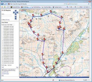
Once you have placed the waypoints on the map the left side of the screen will contain a list of all of them, below this is a small bit of blue coloured text simply labeled up as GPX, you need to click this.

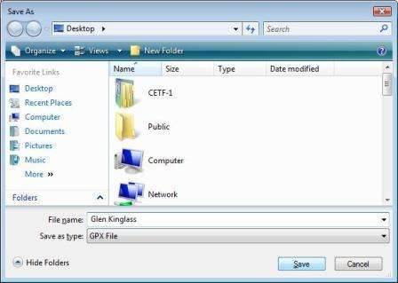
Once you click this GPX link a file save as window will open, enter a name for your new route, in this case "Glen Kinglass" then hit the "Save" button.
The route you have made is now stored on the PC in the GPX format, so now we need to look at exporting this file to the active10.

Connect the active10 to the PC and SatSync should start up, if you drive the PC in manual mode like I do then you will have to start SatSync.
Hit the "Convert to .MAP" button as highlighted:
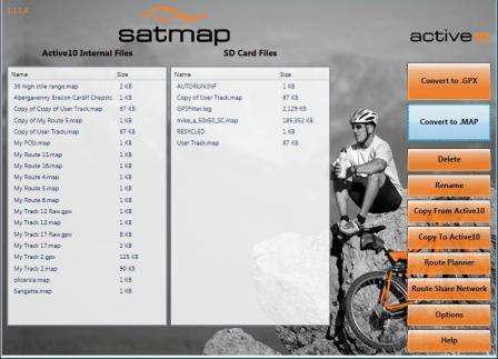
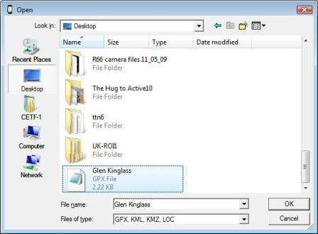
Select the GPX file you previously saved
Use the mouse to select either the internal storage or SD card (if installed) to store you route.
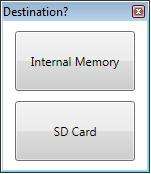
Once you see the "Failed conversions: 0" message all is well and your route is now on the active10.

You can see the route listed in the window of the SatSync software, when the device is re-booted the route will appear for selection on the device.
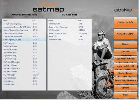
This is easy to use and free of charge, OK so you don't get the 25K scale mapping that the SatMap online planner offers, but at least this goes full screen thus reducing the ammount of map panning operations needed to plan a simple walk - Mike |
|
| Back to top |
|
 |
Not_lost_yet
Occasional Visitor

Joined: Apr 26, 2009
Posts: 16
Location: Nottingham UK
|
 Posted: Wed May 27, 2009 4:23 pm Post subject: Posted: Wed May 27, 2009 4:23 pm Post subject: |
 |
|
Many Thanks mikealder from all of us novices out here.
What a lot of work you have put into this very comprehensive procedure we should follow.
Well done I'm sure we all appreciate it.

_________________
I can cope with fantasy, It's reality that has me beat.
SatMap Active10, Anquet Maps V06, |
|
| Back to top |
|
 |
mikealder
Pocket GPS Moderator


Joined: Jan 14, 2005
Posts: 19638
Location: Blackpool , Lancs
|
 Posted: Wed May 27, 2009 4:28 pm Post subject: Posted: Wed May 27, 2009 4:28 pm Post subject: |
 |
|
Glad you like it, I actually use Quo and/ or Memory Map as well as the SatMap online planner, but the Hug based solution is a free way to acheive basic route planning and it is one of the easiest to use - Mike
Edit to resolve typo - Mike
Last edited by mikealder on Wed May 27, 2009 7:44 pm; edited 1 time in total |
|
| Back to top |
|
 |
ocam
Occasional Visitor

Joined: Nov 08, 2007
Posts: 46
|
 Posted: Wed May 27, 2009 7:24 pm Post subject: Posted: Wed May 27, 2009 7:24 pm Post subject: |
 |
|
| Thanks for the big effort, Mike, much appreciated. Can't wait to sit down and actually have a good go at long last! I'm blummin useless trying to suss that sort of stuff out on my own. |
|
| Back to top |
|
 |
cpjgc
Occasional Visitor

Joined: Jun 26, 2009
Posts: 1
Location: Bristol
|
 Posted: Fri Jun 26, 2009 10:29 pm Post subject: Satmap Route planner Posted: Fri Jun 26, 2009 10:29 pm Post subject: Satmap Route planner |
 |
|
I thought it might be just me, but obviously some other users out there don't think that Route Planner is the best thing since sliced bread.
My GPS background is a plain and simple Garmin e-Trex, coupled with Memory Map. A few months ago I decided to spend a large wad of cash and 'upgrade' to the A10. More cash was spent on the LiIon pack, then even more on some maps. I just missed the free Route Planner option, so yet more hard-earned cash left my wallet!
I have to admit that the A10 itself is great, but SatSync and Route Planner are some of the worst pieces of software I have ever had the misfortune to use.
One thing I always did with the e-Trex was to download my track (or trail) to Memory Map to check exactly where I'd been. Dead easy - almost plug and play. I might even want to print this out for posterity. Dead easy - press the print button.
With SatSync and Route Planner I just lose patience as the whole process is too darned fiddly. The main issue is the size of the screen. And the response speed is awful. And the maps don't print properly. And you can't use it standalone. And you have to remember your A10 serial number to log in. I could go on........... |
|
| Back to top |
|
 |
cwmboy
Occasional Visitor

Joined: Jun 13, 2006
Posts: 45
Location: Berkshire
|
 Posted: Sat Jun 27, 2009 11:45 am Post subject: Posted: Sat Jun 27, 2009 11:45 am Post subject: |
 |
|
Agreed. I too lost patience and either plan my routes directly on the Satmap A10 device or I use Anquet as my preferred software for all of the reasons cpjgc mentioned.
_________________
I Go To The Hills.............
Garmin 12XL
Garmin Vista
Satmap A10
Anquet Maps 6.2.10 |
|
| Back to top |
|
 |
nonoftheabove
Regular Visitor

Joined: Oct 27, 2007
Posts: 82
|
 Posted: Sat Jun 27, 2009 3:30 pm Post subject: Posted: Sat Jun 27, 2009 3:30 pm Post subject: |
 |
|
just a heads up cwmboy the latest Anquet software version is
6.2.10 :- i have just been upgrading software and cleaning up the desktop
Sorry to go slightly off thread. |
|
| Back to top |
|
 |
cwmboy
Occasional Visitor

Joined: Jun 13, 2006
Posts: 45
Location: Berkshire
|
 Posted: Sat Jun 27, 2009 5:37 pm Post subject: Posted: Sat Jun 27, 2009 5:37 pm Post subject: |
 |
|
Ah, thanks noneoftheabove. Just checked and I am running 6.2.9 so I will upgrade as soon as! Need to update my sig too!!
_________________
I Go To The Hills.............
Garmin 12XL
Garmin Vista
Satmap A10
Anquet Maps 6.2.10 |
|
| Back to top |
|
 |
|
![]() Posted: Today Post subject: Pocket GPS Advertising Posted: Today Post subject: Pocket GPS Advertising |
|
|
We see you’re using an ad-blocker. We’re fine with that and won’t stop you visiting the site.
Have you considered making a donation towards website running costs?. Or you could disable your ad-blocker for this site. We think you’ll find our adverts are not overbearing!
|
|
| Back to top |
|
 |
|