| View previous topic :: View next topic |
| Author |
Message |
sooty521
Occasional Visitor

Joined: Feb 26, 2006
Posts: 22
|
 Posted: Tue Apr 22, 2008 10:25 pm Post subject: TT Rider 2 and XDA Orbit 2 help! Posted: Tue Apr 22, 2008 10:25 pm Post subject: TT Rider 2 and XDA Orbit 2 help! |
 |
|
I have just upgraded my XDA Orbit to an Orbit 2
My Orbit used to pair with the TT Rider 2, so I could make handsfree calls, but the new Orbit 2 does not have the features required!!
Could this be a WM6 problem, and is there any fix?
Thanks for any help |
|
| Back to top |
|
 |
mikealder
Pocket GPS Moderator


Joined: Jan 14, 2005
Posts: 19638
Location: Blackpool , Lancs
|
 Posted: Wed Apr 23, 2008 7:05 am Post subject: Posted: Wed Apr 23, 2008 7:05 am Post subject: |
 |
|
| Download the CAB file from This Page, install it to your Orbit-2 and it will put the all important Bluetooth DUN profile on your device - Mike |
|
| Back to top |
|
 |
sooty521
Occasional Visitor

Joined: Feb 26, 2006
Posts: 22
|
 Posted: Wed Apr 23, 2008 9:20 am Post subject: Posted: Wed Apr 23, 2008 9:20 am Post subject: |
 |
|
Many thanks Mike!
When I unzip the downloaded folder, I get 4 files. Do you know if activesync will transfer these automatically, and if not, which folder do I need to transfer them to?
Thanks again for your advice |
|
| Back to top |
|
 |
mikealder
Pocket GPS Moderator


Joined: Jan 14, 2005
Posts: 19638
Location: Blackpool , Lancs
|
 Posted: Wed Apr 23, 2008 11:56 am Post subject: Posted: Wed Apr 23, 2008 11:56 am Post subject: |
 |
|
| Don't unzip the cab file, copy it as downloaded to your Orbit 2 then use file explorer on the orbit 2 to locate the file and tap it. This action will install the required profile to the phone - Mike |
|
| Back to top |
|
 |
sooty521
Occasional Visitor

Joined: Feb 26, 2006
Posts: 22
|
 Posted: Wed Apr 23, 2008 7:03 pm Post subject: Posted: Wed Apr 23, 2008 7:03 pm Post subject: |
 |
|
| Thanks again Mike, will give it a go! |
|
| Back to top |
|
 |
sooty521
Occasional Visitor

Joined: Feb 26, 2006
Posts: 22
|
 Posted: Wed Apr 23, 2008 9:01 pm Post subject: Posted: Wed Apr 23, 2008 9:01 pm Post subject: |
 |
|
Just to let you know, that has worked brilliantly, and I now have full functionality!!
Thanks again for the great advice |
|
| Back to top |
|
 |
mikealder
Pocket GPS Moderator


Joined: Jan 14, 2005
Posts: 19638
Location: Blackpool , Lancs
|
 Posted: Wed Apr 23, 2008 9:20 pm Post subject: Posted: Wed Apr 23, 2008 9:20 pm Post subject: |
 |
|
Glad to hear it is working, blame Microsoft for that one in removing the DUN profile in the first place!
Another neat little dodge/ hack with the Orbit-2 is to enable the GPS mode on the camera, this allows you to view where you took a picture with the phone on Google Earth for example. It has a few problems but works dependent upon location, if you are between 0 degrees and 0,999 Degrees West it will mess up, elsewhere it is fine - interested in trying this out? - Mike |
|
| Back to top |
|
 |
sooty521
Occasional Visitor

Joined: Feb 26, 2006
Posts: 22
|
 Posted: Thu Apr 24, 2008 9:28 pm Post subject: Posted: Thu Apr 24, 2008 9:28 pm Post subject: |
 |
|
Hi Mike
Would not mind giving that a go, as it would be useful for my job to get an exact fix in GE.
Any more details?
Thanks again |
|
| Back to top |
|
 |
Condy
Occasional Visitor

Joined: Jul 11, 2007
Posts: 1
|
 Posted: Fri Apr 25, 2008 12:46 pm Post subject: Posted: Fri Apr 25, 2008 12:46 pm Post subject: |
 |
|
Hi
I was wondering if anybody could help with a fix for a problem I am having with my MDA Vario II and Tomtom Rider ?. Iam using Wm6 and have downloaded the BTdun file and set my phone up with the rider for calls ok, but when I try to set it up for wireless data (Tontom plus services) it starts checking, asks for country (UK) then service provider (T-mobile contract) but the scroll bar never gets beyond the 65%. Can anybody help with a solution.
Thanks
Con |
|
| Back to top |
|
 |
mikealder
Pocket GPS Moderator


Joined: Jan 14, 2005
Posts: 19638
Location: Blackpool , Lancs
|
 Posted: Sat Apr 26, 2008 8:16 pm Post subject: Posted: Sat Apr 26, 2008 8:16 pm Post subject: |
 |
|
| sooty521 wrote: | Hi Mike
Would not mind giving that a go, as it would be useful for my job to get an exact fix in GE.
Any more details?
Thanks again |
First of all you will need a Reg Edit application on your device to do this. I should also mention that messing around in the registry can ruin a device, so only tweak values that are from reputable sources. If you don't have a reg edit application you can download one from Here and use the PC/ Active Sync to install it it to the device.
Note that if you live between 0 degrees and 1 degree West the device will mess up with the actual recorded position, the values are correct but the E/W values get messed up, if you travel further West than one dgree then you have no problems, it will simply work.
The following advice from another post I made about 12 months ago still applys:
| mikealder wrote: | Please read through all of the instructions before deciding this is worth trying!
First of all you will need a registry editor program, I use PHM Reg Edit and/ or Kilmist Reg Edit – but any will suffice.
Start the Reg Edit program and go to :-
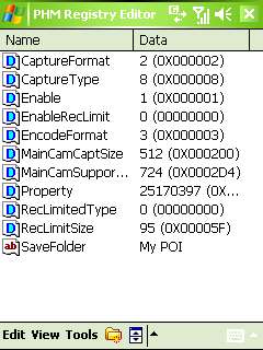
My Device/ HKEY_LOCAL_MACHINE/ SOFTWARE/ HTC/ Camera/ P9 and your screen will look like:

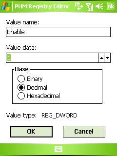
Tap the “Enable” line and change the value from 0 to 1
On the Orbit-2 you should also change the following:
Tap the "EncodeFormat" line and change the value to 3
then click OK
Exit the registry edit program then press and hold the Power On/ Off switch, when prompted “Do you want to continue” answer yes, this saves the data.
Using the reset switch is unreliable and doesn’t always save the modified settings. Switch on the unit and allow it to boot up.
Select the camera function, then change the mode with the selector top right, you are looking for this screen:

Note you will need to be outside as the camera needs a GPS fix in order to function when using this mode.
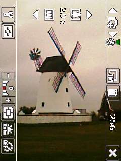
(Note the new icon showing GPS fix in green upper right). With a GPS fix the camera functions as normal, so go and take some pictures with the device in GPS mode.
Once you have done the above your GPS tagged pictures can be found in the My Device/ StorageCard/ MyDocuments/ MyPOI folder.
Viewing the additional information
If all you want is to extract the Lat/ Long you can use a reader to view the embedded information. Exif is one of many programs designed to do this, and its free. When you open a picture you can either display the image or view the information
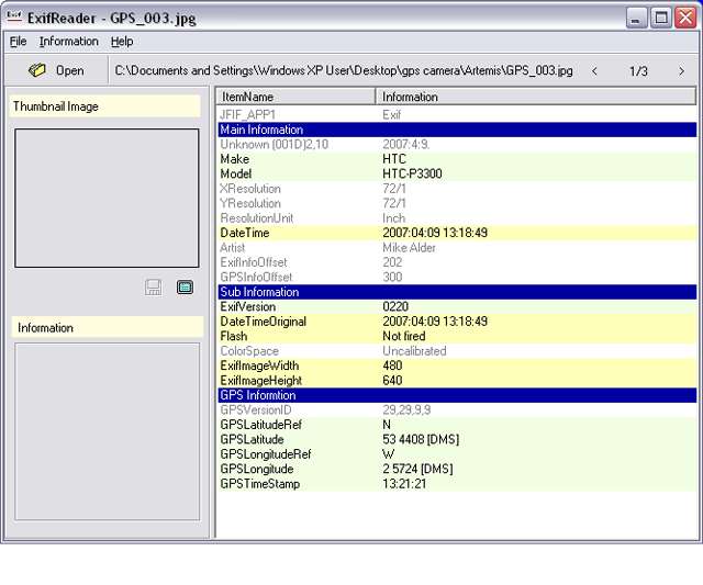
Another (and better method) is to use Panorado Flyer which interfaces with Google Earth, once installed use Windows Explorer to locate your photo files on the PC, right click a picture and select Pandorado Flyer/ Show location in Google earth from the pop-up. This action automatically launches Google Earth and displays the picture on the satellite photograph where it was taken.
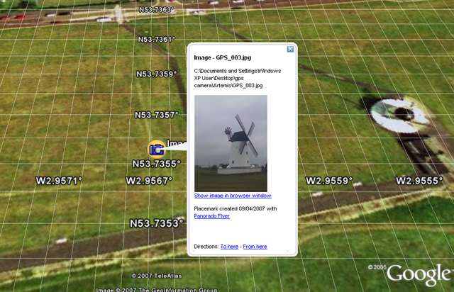
Now for the bad news, the above works fine with the HTC Artemis P3300 but when I tried it on the T-Mobile C-III the lat/ long seconds value were the same, this results in a positional error. In the Lytham Windmill photo the error was 305 Meters.
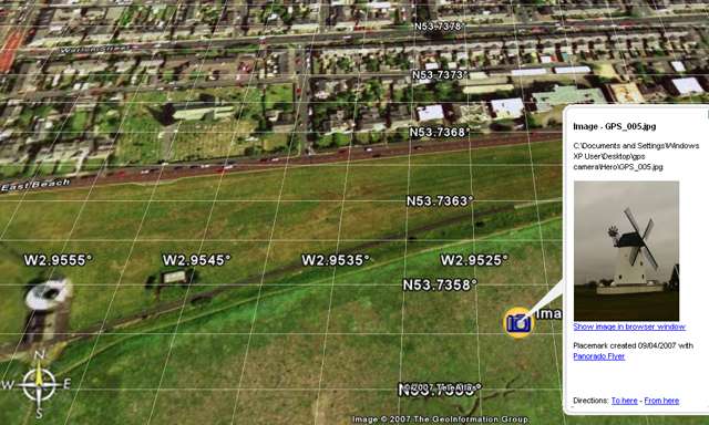
MikeB reported similar findings earlier with the XDA-Orbit, why the Artemis works and the others don’t is a mystery at the moment, unless anyone has any suggestions?
WARNING MESSING AROUND WITH THE REGISTRY CAN CAUSE YOUR DEVICE TO BECOME UNSTABLE, PLEASE DON’T BE TEMPTED TO “PLAY UNLESS YOU ARE CONFIDENT OF WHAT YOU ARE DOING. |
|
|
| Back to top |
|
 |
|
![]() Posted: Today Post subject: Pocket GPS Advertising Posted: Today Post subject: Pocket GPS Advertising |
|
|
We see you’re using an ad-blocker. We’re fine with that and won’t stop you visiting the site.
Have you considered making a donation towards website running costs?. Or you could disable your ad-blocker for this site. We think you’ll find our adverts are not overbearing!
|
|
| Back to top |
|
 |
|