Hi! We see you’re using an ad-blocker. We’re fine with that and won’t stop you visiting the site.
But as we’re losing ad-revenue from this then why not make a donation towards website running costs?. Or you could disable your ad-blocker for this site. We think you’ll find our adverts are not overbearing!
Posted: Fri Mar 07, 2008 12:09 pm Post subject: Map difference between WE, and W&CE, I have noticed...
Just a heads up.
As per my signature strip, I have both Western Europe, v715, and ALSO Western and CENTRAL Europe, v715, but the special 2Gb version of it, for Go 720 devices.
I oft wondered if there was any actual quality difference to the map, given the compression needed to get the W&CE map under 2GB (even though it is not that much smaller in real terms than the normal W&CE v715 - the 'big brother' just tips the scales at 1927MB hence why just too big to fit on a 2GB device).
So using the W&CE 2GB map for the last week or so, it just 'seemed' in general terms, like the 3D view driving map screen seemed more vector based, and blocky, if you follow.
So today I set about to try and prove or disprove this.
And sure enough, as best I can tell, this is the case.
Alas, I don't have two devices to test side by side, admittedly, so the best I could do was find some twisty roads, or roads with a long curving bend to them, and keep swapping between maps, "remembering" the view on the screen between each.
And I have found that on the W&Central Europe 2GB map, roads are made up of less 'segments' than on the Western Europe map alone.
For example, a road near where I live, that bends quite sharp, but long... On W&CE this bend was made up, on the 2D driving view, of two segments, that is, a length, then another diagonal angle off from it.
But on the WE only map, this road in front of me looked much more 'curvy' as it was made up of three separate distinct segments - thus making the bend looking a more natural curve.
The same was reflected for other roads.
Now, my problem is, this is not altogether scientific.
But it is the best I can do with one device, and bear in mind, these tests were made when the vehicle was stationery, in the exact same position.
So it seems that the 3d vector rendering of the W&Central Europe 2GB map, is less, or rather, compressed, compared to the standard Western Europe one.
Just some info, for those also having a choice which one to use...
Joined: Mar 01, 2005 Posts: 1513 Location: West Mids
Posted: Fri Mar 07, 2008 1:10 pm Post subject:
If you make a folder on your device called "screen" then make an empty file in that called "capture" (no extension), you can make screenshots. You tap in the top-left corner and it makes a shutter noise. Next time you connect to the PC, you will see all the bmps in the screen folder.
Just saying as it would be nice to see your examples.
If you give the co-ordinates (OK, not near your home), we can see what it looks like on other maps.
(To make "capture" start making a text file in notepad but, before typing anything, 'Save As...' File name: 'capture' with type: 'All files') _________________ Gerry
TomTom730T
Cameralert for Android
Brodit ProClip mount
If you make a folder on your device called "screen" then make an empty file in that called "capture" (no extension), you can make screenshots. You tap in the top-left corner and it makes a shutter noise. Next time you connect to the PC, you will see all the bmps in the screen folder.
Just saying as it would be nice to see your examples.
If you give the co-ordinates (OK, not near your home), we can see what it looks like on other maps.
(To make "capture" start making a text file in notepad but, before typing anything, 'Save As...' File name: 'capture' with type: 'All files')
Off to work soon - but given how simple it sounds, would be happy to run it again at one of the sites, and take the screenshots.
Joined: Feb 27, 2006 Posts: 14893 Location: Keynsham
Posted: Fri Mar 07, 2008 6:45 pm Post subject:
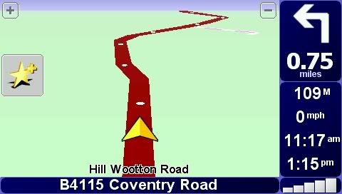
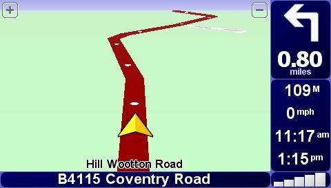
They do it every time they bring out new maps, it seems. These are two previous maps on separate devices mounted alongside each other. (They look to be 0.05 miles different, but I was on the turnover of the measurement). Approx 52.317687, -1.551561, I think.
Yeah Dennis - that's EXACTLY it... that's what mine was doing (albeit, a different location entirely of course).
On v715 Western Europe, I had the road made up of multiple parts, and thus making for a more smooth curvature.
On v715 Western and CENTRAL Europe 2GB, the road was made up of less segments, just as yours was, and consequently looked much more jerky, and artificial.
Note, in my case these were both "v715" maps - but of different regional types.
But that was the point I was hoping to highlight - that even with two v715's the results are different, given the map area coverage.
Cheers for the screenshots - far better than I could likely have done.
Will happily still try and get some tomorrow if people still want me to though, but Dennis has done a grand job showing what I mean.
Posted: Today Post subject: Pocket GPS Advertising
We see you’re using an ad-blocker. We’re fine with that and won’t stop you visiting the site.
Have you considered making a donation towards website running costs?. Or you could disable your ad-blocker for this site. We think you’ll find our adverts are not overbearing!
You cannot post new topics in this forum You cannot reply to topics in this forum You cannot edit your posts in this forum You cannot delete your posts in this forum You cannot vote in polls in this forum
Or you could disable your ad-blocker for this site. We think you’ll find our adverts are not overbearing!
Hi! We see you’re using an ad-blocker. We’re fine with that and won’t stop you visiting the site.
But as we’re losing ad-revenue from this then why not make a donation towards website running costs?. Or you could disable your ad-blocker for this site. We think you’ll find our adverts are not overbearing!