|
Review by Peter Kessler for Pocket GPS
If you enjoy walking in the countryside, but are never quite sure whether the
path on the map is actually the one you're standing on, the Holy Grail has
arrived.
Memory-Map Navigator puts Ordnance Survey maps on your Pocket PC screen and,
when connected to a GPS, lets you follow routes with ease.
What's in the box?
The Memory-Map software comes in two parts, and you have to buy each separately:
the Navigator software, and the maps. Memory-Map have split the UK up into
twelve areas, and each area can be bought on a single CD. The map on the
CD is divided into dozens of 'tiles', and these can be downloaded en masse or
individually to your PC. (The basic Navigator ships with a large-scale map of
the UK, including an index of four
thousand place names.)
Merging Tiles
One now-redundant annoyance with the basic software is that, if you are
planning a walk that crosses from one tile to another, you can't see both tiles
at the same time. Memory-Map have solved this by putting a
free download on their web site called Merge Tiles. This allows you to combine
any number of tiles into one SuperMap. But beware: I found that very large
SuperMaps (such as those combining all the tiles on the CD)
caused Navigator to crash on my PC, which is a Pentium 4 with 40 Gb of space.
Fortunately, you'd rarely need such a large SuperMap, and combining two or three
tiles causes no problems at all. The maps are electronic versions of the
Ordnance Survey 1:50,000 Landranger series. While these are fine for walking,
they aren't as good as the 1:25,000 'Explorer' series of OS Leisure maps which
cover popular walking areas such as the Lake District. Memory-Map plan to
introduce these in the future but at the time of writing have no fixed date for
release.
Planning a route
Planning routes is extremely easy. You simply plot a series of way points
onto the map on your PC. You can zoom in and out to make way point positioning
as accurate as possible. You can move the way points around, insert new ones in
the middle, label them and delete them. When you're happy with your route, you
can 'Lock' it so that you don't accidentally shift a way point later on with a
carefree sweep of the pointer and send yourself off a cliff. Navigator tells you
the distance between each way point and the total distance of your route. Unfortunately it doesn't have any way of totting up only a part of the route,
which would be very helpful. For example, you might want to know how far your
walk is up to a particular landmark. It would also be useful to be able to
break routes up into shorter sections, for example if you wanted to plan an
escape route for when you realise you're not as fit as you were fifteen years
ago.
Communicating with the Pocket PC
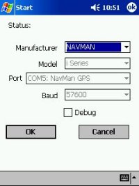
I use Memory-Map with a Compaq iPAQ 3850 equipped with a Navman GPS sleeve.
Downloading the data from the PC is straight forward. Navigator sends a pocket
version of itself to your Pocket PC, and individual map tiles take up about five
to eight MB each. To hold the data, I'd recommend the use of an SD card inserted
into the iPAQ, not a Compact Flash card inserted into the Navman sleeve. This is
because the drain on the iPAQ's battery is greatly increased by a Compact Flash
card, and you're going to need to preserve as much power as possible if you want
a full day's walking.
Once you've sent your map to the Pocket PC, you can download your
route or routes. The Pocket version of Navigator allows you to alter
routes and even make new ones in the field. It's a bit more fiddly than
doing it on the PC, but still very simple and intuitive.
|
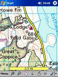
Reproduced
from Ordnance Survey 1: 50,000 mapping © Crown copyright.
All rights reserved.
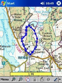
Reproduced
from Ordnance Survey 1: 50,000 mapping © Crown copyright.
All rights reserved. |
|
Using the GPS.
Now the fun really starts. With the Navman sleeve attached (and
after the notoriously long TTFF) you appear on the map as a flashing red circle
with a cross-hair. As you move, an arrow emerges from the red circle, indicating
your direction. The length of the arrow shows where you will be in ten minutes
if you continue at that speed (a feature I find particularly pleasing although I
don't know why). Despite this, however, there is no facility for calculating how
long a walk will take. The screen can also display your altitude, which
further helps to confirm your location when you're halfway up the highest
mountain in
Britain. As you move, a red track appears behind you on the screen, like a
snail's spoor. All you need to do is keep on the route you've planned, and you
just can't go wrong. If you want to move the map around you just drag it with
the pointer. Memory-Map's 'QuickChart' technology makes the map move fast with
almost no re-drawing time. In practice, on a 16-mile walk up Sca Fell
Pike, I found Memory-Map an utterly liberating experience. There's none of the
old anxiety over whether that little path you passed five minutes ago might have
been the right path after all. Even better, it allows you to go off-track with
confidence, such as taking a short cut. At the end of your walk you can
transfer your actual track back to your PC and keep it for the next time you
make that particular trip.
Incidentally, Memory-Map Navigator won't work if any other GPS software is
currently running, and that applies to Navman GPS as well as SmartPath or
SmartSt Pro.
Bad weather
So now we come to vital accessories. If you want to walk in the open air
with a computer, it's got to be protected against the elements.
Fortunately there are a couple of purpose-made waterproof bags available
through Memory-Map's web site and elsewhere. One allows cable access, the other
doesn't. I use the cheaper version and found it worked fine (and yes, we did get
a bit of rain).
Recharging the battery
The other thing you need if you want to go on a long walk is some way of
recharging the battery. Of course, you don't need to keep your Pocket PC
switched on all the time. You could just use it to check your location
whenever you're unsure. If so, the battery will last a full day. But the joy of
this product lies in being able to glance down whenever you want and see your
location. The answer is a zinc-air battery-pack from Instant Power (www.instantpower.co.uk). These come in the form of a dedicated cable and disposable battery packs. The
packs cost about Ł5 and according to the literature each one gives three
complete charges.
The only trouble is that, in order to be absolutely secure from the elements,
you'd need to buy the more expensive waterproof bag so you can connect the
zinc-air charger without disturbing the seal. Even then,
you'd have difficulty keeping the charger dry, as it has to be exposed to the
air in order to work.
Little-known feature
If you happen to spot an osprey's nest on your walk, Memory-Map
Pocket Navigator has a neat feature to help you keep a precise record of it.
By
pressing the 'Record' button on your iPAQ you can record a voice message which
is allocated a precise map-grid reference by the software. This could be
especially useful if one of your party suffers an accident and you have to go
for help.
Upgrade
At the start of November Memory-Map will be releasing an upgrade to
Navigator which includes several improvements (embargoed until release date).
So to summarize:
Pros
-
For leisure walking it's perfect, and doesn't seem to have any
competitors.
-
Easy to operate.
-
Great features.
-
Route-making and tracking are clear and accurate.
-
Map tiles can be connected into Supermaps.
-
Good range of useful accessories.
Cons
-
1:25,000 scale maps would be better for walking.
-
Route-making would be improved by the ability to break routes
into shorter sections.
-
No method of recharging the battery without exposing either the
unit or the battery charger to rain.
|


