Home PageFacebookRSS News Feed
PocketGPS
Web
SatNav,GPS,Navigation
MacFixer, the iPhone, iPod, and iPad specialists

Garmin announce new touchscreen Oregon handheld range

Date 13th August 2008

Garmin has long been the leader in the handheld GPS market. As time has moved on we have seen improvements in the technology and displays, with the handheld GPS devices becoming more and more powerful. We have also witnessed a convergence between handheld and in-car PNDs. For years now we have been using PDAs with Topo mapping, but Garmin broke that mould with the 60cx range a few years ago.


At CES this year we saw the introduction of the Garmin Colorado with it's controversial wheel control, some people love it others hate it... Now we see the culmination of the development with a touch screen Garmin Handheld the Garmin Oregon series.


Garmin have 3 models in the range with varying specifications and included maps. All have the capability to load additional mapping and data on a microSD card, and will provide users with turn by turn navigation (if the correct maps are loaded).


The Oregon is waterproof to IPX7 specification, which is a good thing when pursuing outdoor activities in the UK in Summer. It also means that the GPS can be used for more interesting sports such as canoeing or sailing.


Lets not forget the cyclists amongst us. If you have an Oregon and a heart rate monitor or cadence sensor then the GPS can connect and log your data on your trip.


If your friends have either an Oregon or a Colorado Garmin GPS then you can share your data wirelessly between devices... How neat is that?


Look at the specifications and mapping options carefully before deciding which model to buy. The Oregon 200 only comes with a basemap which is not very detailed. The Oregon 300 has a World basemap with digital elevation so it can show shaded contours. Finally the Garmin Oregon 400t comes with 3D Topo maps of Europe (or North America) at a 1:100,000 scale.


If you are looking for a good all-round GPS then you cannot go wrong with the Garmin Oregon. However at £429 for the top of the range Oregon 400t then an additional £68 for European and £85 for North American detailed street maps the cost soon mount up.


Look out for the Garmin Oregon in the shops from September 2008.


News Article by Mike Barrett


Garmin Specifications for the Garmin Oregon 400t

Physical & Performance:

Unit dimensions, WxHxD: 2.3" x 4.5" x 1.4" (5.8 x 11.4 x 3.5 cm)
Display size, WxH: 1.53"W x 2.55"H (3.8 x 6.3 cm); 3" diag (7.6 cm)
Display resolution, WxH: 240 x 400 pixels
Display type: Transflective colour TFT touchscreen
Weight: 192.7 g (6.8oz) with batteries
Battery: 2 AA batteries (not included); NiMH or Lithium recommended
Battery life: 16 hours
Waterproof: yes (IPX7)
Floats: no
High-sensitivity receiver: yes
Interface: USB and NMEA 0183 compatible
RoHS version available: yes


Maps & Memory:

Basemap: yes
Preloaded maps: yes (European topographic)
Ability to add maps: yes
Built-in memory: yes
Accepts data cards: microSD™ card (not included)
Waypoints/favorites/locations: 1000
Routes: 50
Track log: 10,000 points, 20 saved tracks


Features:

Automatic routing (turn by turn routing on roads): yes (with optional mapping for detailed roads)
Electronic compass: yes
Barometric altimeter: yes
Geocaching-friendly: yes (paperless)
Outdoor GPS games: yes
Hunt/fish calendar: yes
Sun and moon information: yes
Tide tables: yes
Area calculation: yes
Custom POIs (ability to add additional points of interest): yes
Unit-to-unit transfer (shares data wirelessly with similar units): yes
Picture viewer: yes


Additional:
Touchscreen: yes


Official Garmin Press Release

Garmin’s Touchscreen Oregon™ Series Gives Outdoor Enthusiasts the World at their Fingertips


Garmin the global leader in satellite navigation, today introduced the Oregon series of handheld GPS devices for outdoor, marine and fitness enthusiasts, combining an intuitive touchscreen interface, rugged, resilient design and a variety of preloaded mapping options.


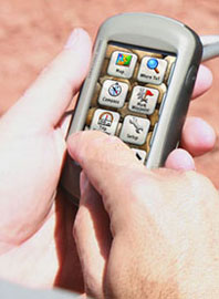
“The Oregon’s vibrant screen is responsive to the touch of your finger, yet resistant to the forces of nature,” said Clive Taylor, Garmin’s Director of Product. “Combining the touchscreen interface of our leading automotive devices with the preloaded features of our acclaimed recreation products makes this the ultimate outdoor handheld.”


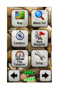
Easy to learn and simple to use, the Oregon features a high-sensitivity GPS receiver, preloaded mapping and a high-resolution, colour 3-inch screen that reacts as users tap or drag through menus and options. On a mountain or an ocean, satellite reception is even faster than before thanks to Garmin’s new HotFixTM feature, which automatically calculates and stores critical satellite information and can use that information to quickly calculate a position without waiting for data collection from the satellites.


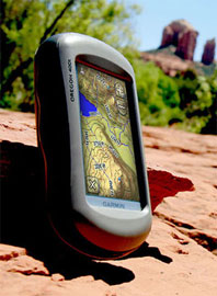
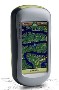
The top of the range Oregon 400t gives hikers a preloaded European topographic map at approximately 1:100k scale*, with street-level detail and state-of-the-art 3D elevation perspective. The Oregon 300 features a worldwide basemap with shaded relief and the Oregon 200 provides a basemap that can be easily supplemented with additional mapping or charts for your adventures on land or at sea.


The Oregon series plays well with others, as the 400t and 300 allow for wireless exchange of tracks, waypoints and geocaches between other Oregon units and Colorado models. Each of these models is equipped with a barometric altimeter and electronic compass and are compatible with Garmin’s heart-rate monitors and speed/cadence sensors giving you the ability to monitor your fitness and cycling speed whilst out and about.


Garmin knows its users have many interests, so the Oregon lets you customize five profiles — automotive, marine, recreation, fitness or paperless Geocaching — making the most beneficial features for each activity the easiest to access through quick shortcuts.


Oregon users can experience Wherigo™, the newest GPS-based activity from Groundspeak, the people who made Geocaching a worldwide phenomenon. Wherigo (pronounced "where I go") is a toolset for creating and completing adventure games, historical tours or other innovative activities in the real world. And Geocaching is even easier with the Oregon, which quickly downloads online information for every cache, such as location, terrain, difficulty, hints and description, so that you don’t have tote printouts with you.


Weighing only 193g with up to 18 hours of life from two AA batteries, the Oregon has a microSD card slot that is ideal for loading additional MapSource detail. For more about the Oregon’s features, pricing and availability, go to www.garmin.co.uk and www.garmin.blogs.com.


RRP is: Oregon 200 - €349 Euros / £279, Oregon 300 - €429 Euros / £329, Oregon 400t - €529 Euros / £429

References

Manufacturers Website

www.garmin.com

Pocket GPS Contributor

Mike Barrett

Pocket GPS Contributor Website

www.Pocketgpsworld.com


Comments
Posted by uffe73 on Wed Aug 13, 2008 5:24 pm Reply with quote

I played with this device in a store a couple of weeks ago and was impressed by its user friendliness. Its GUI is really much nicer than both the Colorado and the 60Csx However it doesn't feel as robust as the other two with its touch screen. It also appears as Gamin's products need a couple of years of bug fixes before they are mature enough (conclusion from reading various forums on the web). You can find more about this here.


TomTom GO720T: App ver 8.351(9982/090518), OS:315187, GPS v1.20, Boot 5.5120
TT RDS-TMC: 4V00.013
Maps: Scandinavia v840.2562, Western_Europe v715.1703
Garmin GPSMap 60CSx (SW ver. 3.70)

 
Reply to topic

CamerAlert Apps


iOS QR Code


Android QR Code


© Terms & Privacy

GPS Shopping