| WAZE - Driver generated mapping, traffic and navigation
Article by: Darren Griffin
Date: 7 Nov 2010
 We've touched on WAZE in the past but I was asked to re-visit the project recently and having done so I must say I'm quite impressed. We've touched on WAZE in the past but I was asked to re-visit the project recently and having done so I must say I'm quite impressed.
Let me say from the outset though that, while WAZE claim they offer navigation, from my testing of the map data I have found that aspect of the service ropey at best and almost unusable.
However, if we ignore that feature and approach it as a service that encourages drivers to use the app to capture road data then it suddenly begins to make more sense. The beauty of WAZE is that it takes a Social networking approach to map making.
Launch the app and create an account and you're a new 'Wazer' ready for the off. The app, free and currently available for Android, Blackberry (Beta), iPhone, Symbian and Windows Mobile is very simple to use, just drive!
You will see your position on the map and by driving along roads you are confirming they exist and earning points.
Some roads have dots along them, these are newly reported roads or less well travelled. If you drive along them your cursor turns into a Pacman style chomper who eats up all the dots. This serves to confirm the road exists and earns you more points.
You can report road traffic issues which are then sent to other Wazers. The app allows you to report traffic, accidents, report map errors etc.
If you come across a road that has not been mapped, tap the screen, hit the road roller icon and as you drive, the new road is captured. Tap the icon again at the end and the road is saved.
The beauty of WAZE is you can make it as simple or as complicated as you wish. If you want to, you can log in to the website and edit the roads you have reported, add road names, traffic directions, road classifications etc. If you prefer not to then your reports can be used by more experienced Wazers who will take your reports and edit them.
Because of the interactive element the whole process is much more fun than it would otherwise be and the ease with which you can add new/missing roads encourages you to do so.
The map data in the US does appear much better developed and so perhaps we can look forward to routing that works once our map data has matured. Features such as 2D/3D , North UP or Direction UP and auto day/night are present as well.
The only downside is that, unlike OpenStreetMap, the data collated in WAZE is not open source and so is not made available to others to use. This is a big concern but OpenStreetMap is a much more complex endeavour, and one that the average user would be scared off becoming involved with. It would be great if OSM could look to making map making as easy as it is here.
To get started visit WAZE at www.waze.com.
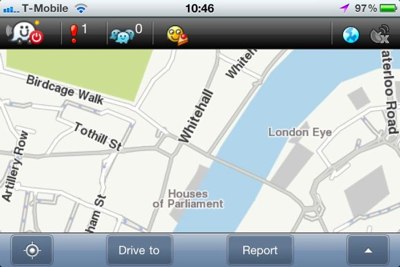
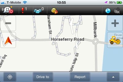
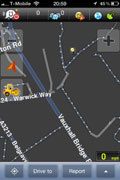
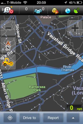
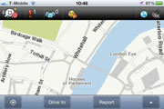
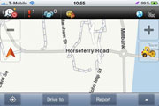
Example Screenshots - Click thumbnails for larger versions.


| Comments
|
 Posted by gatorguy6996 on Sun Nov 07, 2010 12:55 pm Posted by gatorguy6996 on Sun Nov 07, 2010 12:55 pm |
 |
I've only used Waze in the Tampa area. Routing in that metro wasn't bad really. And the smart inclusion of the PacMan like road chomping did get me to take a few roads around my area that I figured weren't yet properly mapped. Actually had some fun helping Waze out.
Garmin 1695 / 255 / 760 w/MSN - Droid w/Google nav + Navigon - Navigon 8100T - Dakota10 - GPSMap76C - GeoMate Jr. |
|
| Posted by Darren on Sun Nov 07, 2010 12:58 pm |
|
| gatorguy6996 Wrote: | | I've only used Waze in the Tampa area. Routing in that metro wasn't bad really. And the smart inclusion of the PacMan like road chomping did get me to take a few roads around my area that I figured weren't yet properly mapped. Actually had some fun helping Waze out. |
The user documentation is pretty sparse but there is lots to like from a data gathering perspective.
The only downside is I'm forever venturing off route to drive a road that needed chomping 
Also they had pumpkin icons dotted around over Halloween that earnt you extra points if you passed over them, a neat touch.
But there is little or no routing in my locale and lots of missing roads, but I'm working on fixing that and the on-line map editor is a lot more friendly than that available in OSM.
Darren Griffin |
|
| Posted by MaFt on Sun Nov 07, 2010 5:06 pm |
|
| News Team Wrote: | | The map data in the US does appear much better developed and so perhaps we can look forward to routing that works once our map data has matured. |
I'm pretty certain they use the TIGER map data that Google used as their base for their own mapping. Happy to be proved wrong though.
By the way, have you tried editing the maps online? I thought OSM was tricky to master but I couldn't do a thing on Waze!!
MaFt
|
|
| Posted by PaulB2005 on Sun Nov 07, 2010 5:21 pm |
|
I'll be giving this a go over the next week or so. Loads of roads missing here but can't help worrying about my fuel economy as I can see myself trying to "catch em all"
It would be good if TT et al could introduce this sort of thing in their software to help with accuracy and spot errors / missing roads much sooner.
|
|
| Posted by Darren on Sun Nov 07, 2010 5:24 pm |
|
| MaFt Wrote: | | I'm pretty certain they use the TIGER map data that Google used as their base for their own mapping. Happy to be proved wrong though. |
I understand they used that when they started as the base to build on when they started. Not sure we ever had TIGER map data here did we?
| Quote: | | By the way, have you tried editing the maps online? I thought OSM was tricky to master but I couldn't do a thing on Waze!! |
I've edited some roads I added a few days ago, found it very simple, what was your issue?
I loaded the track, selected the road and then classified it, marked it as 2-way and named it. Was very easy. Even modifying the road geometry is simple?
Darren Griffin |
|
| Posted by Darren on Sun Nov 07, 2010 5:34 pm |
|
| PaulB2005 Wrote: | | I'll be giving this a go over the next week or so. Loads of roads missing here but can't help worrying about my fuel economy as I can see myself trying to "catch em all" |
Quite, that's what I have found myself doing!
| Quote: | | It would be good if TT et al could introduce this sort of thing in their software to help with accuracy and spot errors / missing roads much sooner. |
It would be a great coup if TomTom could build in the ability to add roads in this manner.
Darren Griffin |
|
| Posted by gatorguy6996 on Sun Nov 07, 2010 6:15 pm |
|
Darren, you're correct about the TIGER data (Topologically Integrated Geographic Encoding and Referencing). That's an American mapping effort undertaken by the US Census.
IIRC, Waze is an offshoot of a similar effort from an Israeli company to map Israeli roads. Think the two principals were related in some way and no longer cooperate with each other.
Garmin 1695 / 255 / 760 w/MSN - Droid w/Google nav + Navigon - Navigon 8100T - Dakota10 - GPSMap76C - GeoMate Jr. |
|
| Posted by Darren on Sun Nov 07, 2010 6:33 pm |
|
Yes that's my understanding. It's a shame OSM can't get an app up to do a similar thing.
Darren Griffin |
|
| Posted by gem on Mon Nov 08, 2010 8:50 pm |
|
I am afraid this is really a gimmick and just a toy.
We have about 20+ GPS manufacturers so why do we need to map our streets all over again??
If it was merged into existing mapping and helping to fix errors then there is a value.
But please don't be distracted from the road when using this Pac Man toy.

|
|
| Posted by Darren on Mon Nov 08, 2010 9:23 pm |
|
That's a very short sighted view. There are many reasons why we would not wish to allow TeleAtlas and Navteq to hold the monopoly on map data.
Waze is just one alternative, OpenStreetMap is another. Already we have fully fledged navigation solutions using OSm map data that is free unlike Navteq/teleAtlas map data.
Waze may not be the the answer but it is far from a toy and does offer some real benefits such as traffic reports and other driving hazard alerts. It is no more distracting than using any other satnav product.
If you don't see the benefit then fair enough but please allow the rest of us to decide for ourselves?
Darren Griffin |
|
| Posted by gem on Tue Nov 09, 2010 10:18 pm |
|
| Darren Wrote: |
If you don't see the benefit then fair enough but please allow the rest of us to decide for ourselves? |
Absolutely - time will tell. But Waze sounds like Was, which as we know is past tense.
As for your comment about driver distraction, I can't remember seeing Pacman on my Garmin/Navigon/Navman. Nor pressing any button to say start recording or end, etc, etc.
As for traffic information, you yourself will know you need a VERY large sample size of vehicles to be of any use. Road Angel users, reporting in real time, speed camera vans is one example.
For traffic to be any good this "Was toy" will need a full team behind it (or pay for the data?) to report all the mainstream incidents plus the ones the users spot and report themselves.
Cheers.
|
|
|
| Click here to view more comments... |
|
 |
|