Hi! We see you’re using an ad-blocker. We’re fine with that and won’t stop you visiting the site.
But as we’re losing ad-revenue from this then why not make a donation towards website running costs?. Or you could disable your ad-blocker for this site. We think you’ll find our adverts are not overbearing!
Intermap Technologies has signed a licence agreement with Tele Atlas for the supply of 3D elevation data.
Derived from Intermap's five metre digital terrain this data will enable Tele Atlas to offer contour elevation data to its mapping customer base.
Navteq already have terrain data which is offered by a number of their customers including Navigon and so this is very much playing catch-up on Tele Atlas' part but it is nevertheless a very welcome move.
Lets hope we will see 3D elevation data on PNDs using Tele Atlas data soon.
Comments
Posted by Privateer on Mon Nov 09, 2009 9:01 pm
News Team Wrote:
Lets hope we will see 3D elevation data on PNDs using Tele Atlas data soon.
I look forward to seeing this kind of data on production PNDs. However surely the the processing power of the PNDs would have to be extremely large to cope with real time display of 3D elevation data to the accuracy of 5 metres.
The chance of driver distraction may also be much greater than the current range of PNDs that don't have 3D elevation data.
Tele Atlas is to be commended on the progress of this type of development. However Tele Atlas must not run before it can walk as it mustn't forget that what its customers and subsequently its end users, the general public, need is not flashy gizmos (those can wait) but accurate navigational data.
Regards,
Robert.
iPhone 6s Plus, iOS 14.0.1: iOS CamerAlert v2.0.7
TomTom GO Mobile iOS 2.3.1; TomTom (UK & ROI and Europe) iOS apps v1.29
Garmin Camper 770 LMT-D
Posted by gatorguy6996 on Tue Nov 10, 2009 12:57 am
Intermap has been busy apparently. They also signed an agreement earlier this month for the same shaded 3D terrain data to be supplied to Mapquest, who uses Navteq maps.
Is MapQuest really licensing from Intermap? Why don't they use Navteq's DEM along with the maps?
Posted by Darren on Tue Nov 10, 2009 10:32 am
Privateer Wrote:
I look forward to seeing this kind of data on production PNDs. However surely the the processing power of the PNDs would have to be extremely large to cope with real time display of 3D elevation data to the accuracy of 5 metres.
It is already being offered and looks great. It adds a much greater sense of location in hilly/mountainous regions.
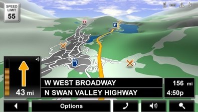
Whether TA use the full 5m resolution remains to be seen as it will doubtless be compressed but look at what can be achieved, here is Navigon's DEM data, looks great!
Hi! We see you’re using an ad-blocker. We’re fine with that and won’t stop you visiting the site.
But as we’re losing ad-revenue from this then why not make a donation towards website running costs?. Or you could disable your ad-blocker for this site. We think you’ll find our adverts are not overbearing!