|
Skobbler launches in UK - iPhone Navigation for Ł1.19
Article by: Darren Griffin
Date: 12 May 2010
 Skobbler, the OpenSource navigation app, has launched in the UK Appstore. Skobbler, the OpenSource navigation app, has launched in the UK Appstore.
Using OpenStreetMap data, Skobbler allows motorists and other users to easily report map errors and make corrections that are fed back to the OpenStreetMap community for the benefit of all users.
Map are delivered over the air (OTA) and so you benefit from constantly updated and improved map data as the user base grows. When launched in Germany, Skobbler quickly became the No1 selling navigation app for iPhone.
Although it has many rough edges, the fact that your corrections are incorporated back into the master OpenStreetMap data makes this unique amongst navigation apps. Instead of months or years before corrections are incorporated, OpenStreetMap reduces this to days. The more users submitting corrections, the better the data becomes.
We've reported on OpenStreetMap on many occasions and covered the unique benefits it brought to aid workers in Haiti. With hundreds of GPS equipped aid workers feeding back corrections the data rapidly improved. Where previously, only a very basic map existed, the map data is now the equivalent, if not of better than that available for European or US cities.
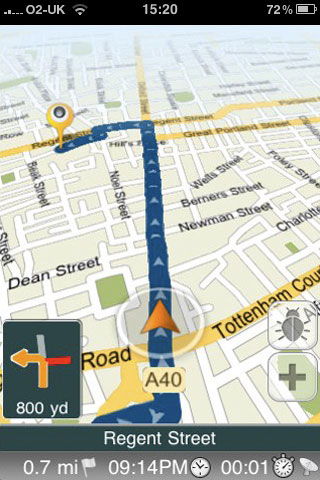
Skobbler offers turn-by-turn navigation, voice guidance, and of course, editable maps. It is available today in the Appstore at a launch price of Ł1.19 (normal price Ł2.39).
What are you waiting for!
For more information visit the Skobbler website at www.skobbler.co.uk.
  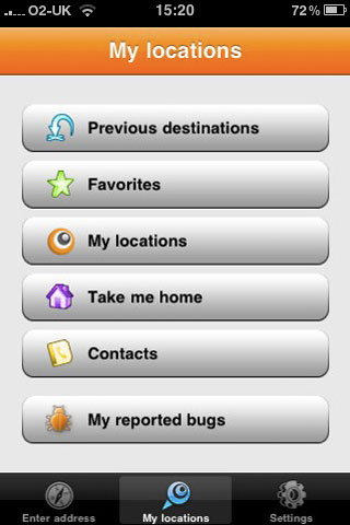
Click thumbnails for larger images
| Comments
|
 Posted by MaFt on Wed May 12, 2010 2:56 pm Posted by MaFt on Wed May 12, 2010 2:56 pm |
 |
furthermore... it looks like they've borriwed navigon's turn signals and countdown as well as copilots arrow-and-circle marker! as well as roadee's orange colour scheme 
still, worth a play though!
|
|
| Posted by Darren on Wed May 12, 2010 9:08 pm |
|
Indeed I thought it had a smattering of Navigon about it.
I suspect 'OpenSource' refers to the use of the OSM data but I have no info on that.
It's not half as bad as I'd feared and anything that encourages us all to add to OSM map data is to be welcomed with open arms in my opinion.
Darren Griffin |
|
| Posted by MaFt on Thu May 13, 2010 12:12 am |
|
i like how it has the 'bug' icon for making on-the-go amendments. not had a full-on play with it yet but i recall you could correct things such as missing roads, wrong turn restrictions etc.
on my brief use tonight it seemed to lag a bit in updating the map - however i was using wifi tethering to my android phone to use it's data connection so it may have been a delay caused by that...!!
i'll have a proper play tomorrow. i know my area is fine as i've spent a lot of time mapping it - i've even gone as far as walking around the perimeter of playing fields and the local cricket club to add some green to the map... i'm going on a drive to the far side of keighley tomorrow so we'll see how it copes where i've not already mapped the place 
MaFt
|
|
| Posted by magnetic on Fri May 14, 2010 7:31 am |
|
The app is not Open Source, the article is misleading in that sense.
|
|
| Posted by magnetic on Fri May 14, 2010 7:46 am |
|
| Darren Wrote: | Indeed I thought it had a smattering of Navigon about it.
|
That's interesting, as skobbler was founded in September 2008 as a management buy-out of Navigon.
Anyway, all turn signals look the same to me, that's not important  . .
|
|
| Posted by jkljkl6 on Fri May 14, 2010 8:24 am |
|
Does anyone know if this works abroad? My (possibly naďve) assumption is OSM is open and global so theoretically this "should" work anywhere.
Admittedly I wouldn't want to use data roaming for any length of time but it could help out in a pickle or in countries where all the others seem to have forgotten. Until recently Google didn't seem to know that Cyprus even had roads where OSM still leads the way (literally).
|
|
| Posted by MaFt on Fri May 14, 2010 8:58 am |
|
| jkljkl6 Wrote: | Does anyone know if this works abroad? My (possibly naďve) assumption is OSM is open and global so theoretically this "should" work anywhere.
Admittedly I wouldn't want to use data roaming for any length of time but it could help out in a pickle or in countries where all the others seem to have forgotten. Until recently Google didn't seem to know that Cyprus even had roads where OSM still leads the way (literally). |
it would but roaming charges would be extortionate! on a relatively short journey yesterday, about 10 miles, it used just under 1mb of data. from memory O2 charge about Ł7 per mb...
MaFt
|
|
| Posted by W6tty on Fri May 14, 2010 9:09 am |
|
Can the speed camera database be used in this app?
|
|
| Posted by Darren on Fri May 14, 2010 9:12 am |
|
| W6tty Wrote: | | Can the speed camera database be used in this app? |
Not as it stands currently, no.
Darren Griffin |
|
| Posted by Glyn on Fri May 14, 2010 9:57 am |
|
I was going to buy this until I read the few reviews that have been written about it on iTunes.
One Star does not bode well for the first incarnation of this app.
Sounds good though...hopefully it will improve in time.
|
|
|
| Click here to view more comments... |
|
 |
|


