| Satmap On-Line Route Planner Goes Live
 Satmap's Route Planner has today been officially launched. Previously available in Beta, the On-Line Route Planner and Route Share website application is now available for use by all Satmap owners. Satmap's Route Planner has today been officially launched. Previously available in Beta, the On-Line Route Planner and Route Share website application is now available for use by all Satmap owners.
Route Planner is based on Microsoft's Virtual Earth platform incorporates global road mapping and satellite images. More importantly is has map layers from Ordnance Survey available in in 1:25k Explorer and 1:40k Landranger scales for the whole of Great Britain. That's over Ł7,500 worth of maps.
Satmap users can plan routes and download them onto their Active10's and also edit uploaded routes, view elevation profiles and print out paper versions as backups for use whilst walking!
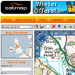
Route Planner
Ordnance Survey mapping © Crown copyright. AM70/08
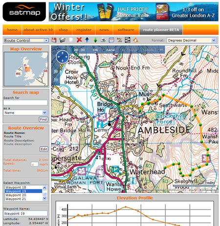
Route Share uses Google Maps and again provides global mapping with satellite and terrain views and also 3D aerial photo views. Users can share routes and categorise them by difficulty, length, activity type etc. Other users can review routes they have downloaded and comment on them and a search facility is also provided.
Route Share Forum
Both services are free to users whom purchased Active 10 devices prior to 23rd March 2009 and registered prior to 1st April 2009. For other customers the service costs Ł79.99.
For Mac users a compatible version is scheduled for later this year.
www.Satmap.com
| Comments
|
 Posted by dave-t on Tue Mar 17, 2009 1:03 pm Posted by dave-t on Tue Mar 17, 2009 1:03 pm |
 |
Excellent!
Been looking forward to this one 
Dave
TT 530, TT 510, SPOT, Quo2, SatMap Active 10 |
|
| Posted by davidor on Tue Mar 17, 2009 1:15 pm |
|
OK, so now it's gone live, can we comment on this forum?
Whilst I don'tr want to detrcat from what Satmap have done, I'm very disa ppointed with this. To get the 1:25K scale up, the area covered is so small that frankly it is easier to plan the route directly on the Satmap.
With all the fuss about it I really thought it would be based on something other than Google maps. If the map view was full screen it would be brilliant, but as it is, with the 1:25k map starting at about one mile square I don't think I will be using it much.
|
|
| Posted by rickwiggans on Tue Mar 17, 2009 1:30 pm |
|
If I print out a route, should I expect to get a print out of the route as displayed on screen? For example, if I have my route displayed on screen on the OS 1:50K overlay, all I get when printing is the route on the base map, not the OS map. Am I missing something, or is it supposed to be like this? (An OS licence restriction maybe?)Also, I notice that on the website, it is still described as Beta. Am I somehow still accessing the beta version (I've gone in through the front page, rather than my previously saved favourite)
Agree with the point raised about small area displayed on screen, but generally pleased with the utility
Rick
|
|
| Posted by LostMike on Tue Mar 17, 2009 4:05 pm |
|
I must say that I'm a bit disappointed that many if not most of the problems I reported in the beta trial are still there. 
LostMike
Satmap A10. Platform 21
Software version 1.5.9193
Satsync 1.525 |
|
| Posted by Tony_P1 on Tue Mar 17, 2009 5:04 pm |
|
Maybe it is still the beta version of the route planner. The urls would suggest so, as would the lack of functionality of some of the menu items.
Puzzled Tony
|
|
| Posted by LostMike on Tue Mar 17, 2009 5:19 pm |
|
If Satmap are going to charge for access to the new features should we get credits for uploading routes? It must increase the value of the facility to them. Otherwise we could instead upload our routes here - something that not many people have taken up so far.
LostMike
Satmap A10. Platform 21
Software version 1.5.9193
Satsync 1.525 |
|
| Posted by Activator on Tue Mar 17, 2009 8:06 pm |
|
When I click on a route that someone else has uploaded on 'route share', it gives me the option to download the file, but on the same page the route or map doesn't show up in the window.
This as never worked for me, but I presumed it was because I was useing the trial version. Will this be rectified as people start uploading routes on the official route planner or am I doing something wrong.
|
|
| Posted by LostMike on Tue Mar 17, 2009 8:24 pm |
|
When or if Satmap are going to make improvements is a question you will have to put to them.
I have noticed that once I have looked at a route once on route share I cannot look at it again unless I completely restart the application or click on "Earth" which seem to reset things so that I can look at it a second time. Don't know if this is the same problem that you are having but it sounds similar.
Hope that helped.
LostMike
Satmap A10. Platform 21
Software version 1.5.9193
Satsync 1.525 |
|
| Posted by Activator on Tue Mar 17, 2009 8:42 pm |
|
Thanks for that, but I can't view the routes at all. The window is there with the arrows to move around, zoom in and out etc., but the box is just white, even if I click on the terrain, earth tabs etc.
|
|
| Posted by KevinDublin on Tue Mar 17, 2009 8:44 pm |
|
I can't see why anyone would pay for this. You can do much the same on www.bikehike.co.uk and many other route planning sites. bikehike uses the 1:50,000 OS but not the 1:25,000 which satmap has. But the area is so small in 1:25,000 on satmap as to make it useless. You get a much larger map area in bikehike and you can toggle between google maps and OS. The routes can be downloaded in .gpx and uploaded to the satmap using satSYNC in the normal way. I tried the beta version of satmap route planning and then went back to bikehike. I was really surprised when I saw they want people to pay for it. I won't be using it even for free.
Kevin
|
|
|
| Click here to view more comments... |
|
 |
|


