 Author: Steven New/Darren Griffin Author: Steven New/Darren Griffin
NATS and Airbox launch Aware GPS device to help pilots avoid controlled airspace.
A new device has come onto the market which fills a small niche area for Private Pilots in the UK.
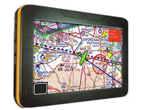
This new device, quite unlike anything else currently available, provides a low cost moving map display using a 4.3" backlit sunlight readable screen and contains the latest UK ICAO 1:500,000 chart.
In essence the devices primary function is to warn when the pilot is approaching, and then about to enter, restricted airspace.
Alerts include:
- Controlled Airspace (Control Zones, Control Areas and Airways)
- Aerodrome Traffic Zones
- Danger Areas and Prohibited Areas
- Restricted Airspace (Temporary) – e.g. air shows and Red Arrows displays
- Transponder Mandatory Zones
- MATZ
- ATZ
- GVS
- PSL
- HIRTA
The Aware device comes with the ICAO 1:500,000 scale UK chart preloaded on the supplied SD card, with more charts available on the manufacturer’s web site. For those pilots who prefer them, including myself, the 1:250,000 scale charts are available to download for a fee.
NATS airspace definition updates are free and digital chart updates are available at a very reasonable £24.99 per chart.
Inside the box
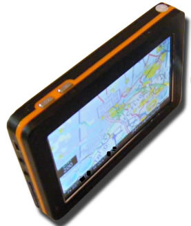
Once you open the small box you will find the unit itself. Well constructed with a metal chassis. the full list of contents includes:
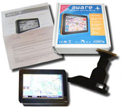 |
- Aware GPS Unit
- 12/24v cigarette lighter power adapter
- 240v power adapter
- USB Cable for computer connection
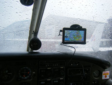
- Windscreen suction mount
- Instruction pamphlet
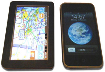
- Dimensions 12cm x 8cm x 1.5cm
- Weight 170g
|
The unit itself is slightly wider than my iPhone, the same height, and slightly thicker.
Although the unit will run for about 1hr on its internal battery, it is recommended that external power is used. If cockpit power is not available as may well be the case if you are using school aircraft or indeed any that do not have provision for accessory power then the Aware device can be powered from an external battery pack via mini-USB. There are a great many solutions but Aware sell the PowerMonkey, a device we have reviewed (see here) which works very well.
The device
 Once the unit has been charged up, it takes around 20 seconds to display the ‘Disclaimer’ screen. After acknowledging that you are taken straight onto the main screen with the map display. Once the unit has been charged up, it takes around 20 seconds to display the ‘Disclaimer’ screen. After acknowledging that you are taken straight onto the main screen with the map display.
Indoors it the receiver was sensitive enough to receive a good GPS signal on occasion but obviously this device is supposed to be used outdoors and in clear view of the sky.
After several minutes outside, I received a good GPS fix and the device displayed my location on the map accompanied by a co-ordinates readout on the bottom left of the screen.
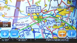
The aircraft icon on the screen turns bright green when a GPS fix has been established. In addition, the Altitude/Flight Level is displayed (more of this later on in the review).
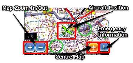
There are + and – icons at bottom left which control map zoom functions. The device comes with a small stylus, possibly a relic of the unit's PND origins. Using a stylus would soon become very fiddly when flying but I found that my fingers were perfectly sufficient!
Main Display
The other two icons in the bottom right corner are for centering the map with the current GPS position if you have moved the map away from the current location, and an ! button which leads to the "Emergency Information" screen which provides the following information:
- Emergency transponder codes
- 7500: Unlawful Interference
- 7600: Radio Failure
- 7700: General Failure
- Emergency frequency: 121.5Mhz
- Your current distance from neartest airfield, heading and current UTC time
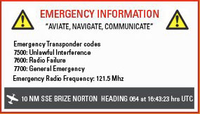
Emergency Information Screen
On top is the On/Off button. On the left hand side of the unit you will find:
- Mini-USB connector for power/data
- 3.5mm headphone socket for connection to a headset or external speaker
- AV in socket
- SD card slot
- Reset button
How does it work?
With the device switched on, GPS fix obtained device and chart loaded the Aware GPS calculates your location and displays it on the chart.
It then takes your heading and altitude/flight level and warns you if you are approaching any applicable controlled/ restricted/ dangerous airspace. I use the work ‘applicable’ because the device takes your altitude/ flight level into account and warns you about any possible airspace incursions that apply to you at that level only.
For example, flying along at 5000 feet, you do not get warned of controlled airspace ahead of you that is only controlled up to 4000 feet as you are not going to enter that controlled area.
The screen shots demonstrates this quite clearly. The device has a 500 feet vertical warning buffer, meaning airspace 500 feet above or below you will also be warned against!
 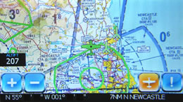
In the screen shot above right, my height above ground level is 207 feet when this photo was taken. You can quite clearly see the Newcastle Control Zone highlighted in bright green. This is because this portion of the control zone is from SFC (surface) to FL 105 (10,500 feet). With myself being at 207 feet, if I were flying here, I could possibly penetrate this controlled area. If you look towards the coast, to the right of the two displayed high obstacles, you will see the extensions of the controlled airspace. These do not start at the surface, but at 1500 feet and 3000 feet respectively. Therefore, these zones are not highlighted as my current altitude/ flight level does not currently threaten that portion of the control zone.
What happens if I am heading towards controlled airspace at an altitude that would penetrate the controlled zone?
So, you are flying along in the cruise nicely and become slightly off course over time and drift towards an area that is controlled airspace. First thing that you would notice on approaching the controlled airspace is that the area concerned will now be highlighted in red, and emit an audible three loud, short ‘pips’. In the top right of the screen will be displayed information about the airspace that is being warned about. This includes information on:
- Class of airspace
- Name of airspace
- Restriction levels
- Distance to the airspace
As you enter the airspace, the device will emit two loud and longer ‘pips’ and the red information box from the top right of the screen will move down to the bottom of the screen.
What about obstacles?
The device will warn about tall obstacles in the same way as for controlled airspace.
The parameters for warnings are:
- Airspace warning valid between sea level – 10,000 feet
- Airspace warning range is 10 minutes
- Vertical warning buffer is 500 feet
- Obstacle warning radius is 0.5 Nautical Miles
Conclusion
The device performs well, with both audible and visible warnings of upcoming controlled airspace. A distance to the alerted zone is also given. Furthermore, a track line is also drawn which shows the current track you are on when heading into controlled airspace. This is a good feature as it shows the pilot where they are about to cross the controlled airspace, and therefore which direction to alter the course to in order to avoid ‘busting’ the airspace.
The unit is also capable of being used as a navigation device, just like a car GPS system. The Aware + includes navigation for £249.00 inc VAT or it can be purchased later as a navigation upgrade for £119 inc VAT. The navigation upgrade was not available for this review.
In conclusion, this is a great piece of equipment which would aid even the most experienced pilot flying VFR in the UK. The initial outlay for the device at £149.00 inc VAT makes it an absolute bargain and one that every pilot ought to consider.
As it also comes with free NATS airpsace definition updates and low cost chart updates it is remarkable value and so deservedly earns our PocketGPSWorld Highly Recommended award.

|


