| Residents take action against satnav map errors
Article by: Darren Griffin
Date: 4 Nov 2009
 Angry residents in salisbury have erected a sign in an effort to warn motorists that their satnav maps are wrong and the road they are driving along is in fact a dead end. Angry residents in salisbury have erected a sign in an effort to warn motorists that their satnav maps are wrong and the road they are driving along is in fact a dead end.
Satnav maps from Tele Atlas AND Navteq incorrectly show Ashdown Terrace in South Tidworth as a through road with a connection to Station road, see here when in actual fact it is a dead end.
Fed up with motorists being directed along this road a local resident has erected a sign near the entrance warning drivers that their satnav map is wrong.
Map errors are by far the biggest complaint made against satnav devices. We all accept that mistakes are inevitable but it is the length of time taken to correct that angers users.
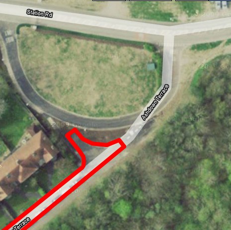
Map courtesy of Google showing error
Actual road layout highlighted in red
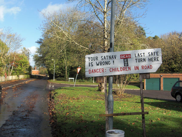
Residents have erected a sign to warn motorists
Thanks to PocketGPSWorld Reader William Goss for the photographs and tip.
| Comments
|
 Posted by falkirk81 on Wed Nov 04, 2009 12:13 pm Posted by falkirk81 on Wed Nov 04, 2009 12:13 pm |
 |
An ideal opportunity for Tomtom's Mapshare to be used to get it blocked on TA map data!
Tomtom GO 1005 LIVE
iPhone 12 |
|
| Posted by MaFt on Wed Nov 04, 2009 12:28 pm |
|
| falkirk81 Wrote: | | An ideal opportunity for Tomtom's Mapshare to be used to get it blocked on TA map data! |
but then when your next update arrives your mapshare fixes don't get carried over to the next map and it still will need fixing again....!
the user who sent us the photo said:
| Quote: | The sign IS correct, and my tomtom 8.10 UKIE v835.2420 with all the map share updates (the maximum setting) was wrong.
I have amemded my tomtom with a mapshare correction, but I bet it gets wiped out on the next map update.
The rolling subscription is not as wonderful as its advertised as you loose many correction and gain a few. |
MaFt
|
|
| Posted by jeff-d on Wed Nov 04, 2009 12:49 pm |
|
I sometimes wonder just how stupid you have to be to work for these mapping companies. Way back in 1994 the outer ring road (the A563) was moved in Leicester. It took until 2006 before the map was changed. Here.
In fact on google maps the overhead photo was correct several years before the mapping data.
|
|
| Posted by Darren on Wed Nov 04, 2009 1:56 pm |
|
| MaFt Wrote: | | but then when your next update arrives your mapshare fixes don't get carried over to the next map and it still will need fixing again....! |
Quite, that was exactly the complaint from the chap who gave me the tip and photos on this. He's fed up with having to re-enter the correction with every update because it is never incorporated.
Darren Griffin |
|
| Posted by G1LIW on Wed Nov 04, 2009 10:57 pm |
|
It's about bleeping time that someone made a package that works on, say, Windows Mobile smartphones/PDAs that uses the open Street map data. (and before you say it, I know about NAVIT. Sadly, NAVIT is all well and good, but it's nowhere near ready for actual navigation use on WM devices - hell, it can only just find itself at the moment!).
My point about OSM data? It's compiled and updated DAILY, from data supplied by the users.
It's what mapshare should have been from the get go, but of course it took someone else to make it work!
Roger, G1LIW
Google Pixel 3a XL Android Smartphone | SatNav Sygic for Android | Waze for Android | CamerAlert for Android | Blog http://rogersblant.blogspot.com/ |
|
| Posted by Darren on Thu Nov 05, 2009 8:10 am |
|
But OSM doesn't have turn by turn data embedded. Great as OSM is, without that info it is of no use for navigation yet.
Darren Griffin |
|
| Posted by MaFt on Thu Nov 05, 2009 12:00 pm |
|
CloudCell, a part of OSM, does though. although it is only provided over the air rather than being downloadable.
Also, this area in OSM has very poor coverage...
MaFt
|
|
| Posted by pcaouolte on Thu Nov 05, 2009 12:45 pm |
|
Navigation based on OSM data would not annoy the residents of Ashdown Terrace in South Tidworth, their road hasn't made it onto OSM maps yet.
We-travel is a free turn-by-turn navigation application that runs on java enabled mobile phones and can navigate using OSM maps. It's in the early stages of development and is not fully functional yet but it does show promise.
Paul |
|
| Posted by mmm-five on Thu Nov 05, 2009 12:53 pm |
|
The Ordnance Survey map of the same area shows it as a through road too. I wonder how long ago the road was changed to add the 'crescent' and 'dead end'?
|
|
| Posted by Darren on Thu Nov 05, 2009 1:06 pm |
|
A very good question. Clearly it must have been an issue for some time to have irked residents but it may still be a relatively recent change.
Darren Griffin |
|
| Posted by GerryC on Thu Nov 05, 2009 1:34 pm |
|
The Google aerial shows the new alignment but the Bing one shows the same as the mapping. Both are dated 2009 (I know that doesn't really mean much) so it looks like a recent change.
If this is so new though, I would have expected signs on the A338 warning of the change but there's nothing obvious there or at the entrance to the estate on the blurry Google overhead to shows it's now a dead end.
The Google pics were in the summer and the Bing ones in winter - see the trampolines in the back gardens.
Gerry
TomTom730T
Cameralert for Android
Brodit ProClip mount |
|
|
| Click here to view more comments... |
|
 |
|


