Hi! We see you’re using an ad-blocker. We’re fine with that and won’t stop you visiting the site.
But as we’re losing ad-revenue from this then why not make a donation towards website running costs?. Or you could disable your ad-blocker for this site. We think you’ll find our adverts are not overbearing!
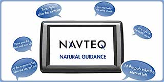
Navteq announce Natural Guidance "Humanising the navigation experience" at IFA 2010. What is natural guidance? Well it is simply navigation instructions as you would get if you stopped and asked a local for directions.
When you are driving and your passenger is navigating you will not hear "after 300 yards take the second right". What you will normally hear is "turn left at the pub". Indeed if you ask for directions they will normally be related to local landmarks. This is where Navteq Natural Guidance comes in.
Navteq have reviewed the navigation data for several major cities including London, Paris, and New York to provide data enabling navigation companies to implement more traditional guidance keys. Thinking about this it is a huge job, and it needs to be duplicated as it must cater for travel in both directions. This is available as a sequence of attributes connected to each junction. These contain details about building type, colour, direction, etc.
Some of these attributes are more permanent than others. For instance a church is much more likely to remain a church, whilst a yellow awning could well be replaced. The same holds true for company names and signs as these can be more transient. To cater for this Navteq place a confidence factor on the attributes allowing the implementation of instructions based on the potential reliability of the navigation key.
These are all encoded in such a manner that they can be used in a number of different languages, This includes phonemes to assist the speech processor in pronouncing the different local names. This means that when you are travelling in a foreign country where you cannot easily read the road signs you can still arrive at your destination as if directed by locals.
When questioned about the additional data size and if that would seriously bloat the map data Navteq told us that the data was quite minimal compared to the 3D mapping and should be easy to incorporate without too much additional storage requirement.
Navteq are facing the challenge of competing against community driven mapping which is offered at no charge to developers. When faced with competition like this then the company needs to have added value the like of which is almost impossible to be made available from community driven initiatives. When questioned about the threat to their core business by groups like Open Street Mapping Navteq were very confident about the strengths of their product. We were told by a Navteq representative, that although the geometry of the OSM data is reasonable particularly in cities the linkages required for navigation are not up to standard.
I suspect that in time the OSM mapping will get to a good national standard which will allow it to compete with Navteq (and Teleatlas) but in the mean time Navteq is producing many value adds to their products that it will still make it viable for integrators to select over and above the free options. These added features will become more and more popular enabling the traditional mapping company to retain it's revenue generation in the face of tough competition. It looks like the Natural Guidance could well be one of the top differentiators between the main map providers.
Navteq have produced a somewhat tacky video to demonstrate the Natural Guidance principals…
The official Navteq press release:
NAVTEQ First to Give Navigation a ‘Human Touch’ NAVTEQ Natural Guidance™ enables navigation directions everyone can relate to
Berlin – 2nd September, 2010 – NAVTEQ, the leading global provider of maps, traffic and location data enabling navigation, location-based services and mobile advertising around the world today launched a new product that promises to materially change the way navigation systems and applications interact with end users. NAVTEQ Natural Guidance™ breaks new ground by enabling guidance the way people provide directions to each other—through the use of descriptive reference cues.
Launched at the IFA consumer electronics show in Berlin, NAVTEQ Natural Guidance leapfrogs today’s linear navigation instructions - e.g. ‘turn right in 50 metres on High Street - by guiding the way people instruct each other: that is through descriptions of orientation points such as distinctive points of interest and landmarks—e.g. ‘turn right after the yellow shop” or ‘turn right at the traffic signal.’ Research shows consumers want more intuitive and practical directions because they are easier to follow and allow drivers to keep their eyes on the road. NAVTEQ Natural Guidance enables applications to use recognisable and easily understandable points of reference close to the decision point to highlight the next manoeuvre.
“Natural Guidance provides the kind of directions we want as people,” said Tiffany Treacy, NAVTEQ senior vice president of product management. “It challenges the man-machine status quo of how navigation systems have worked for years by finally enabling the kind of guidance that sounds like it’s coming from a friend who is riding along with you. This is a revolutionary first step toward more natural and ultimately more personalised experiences.”
Over the past 25 years, NAVTEQ has continually striven to create content specific to navigation which improves the user experience. Only as an expert and innovative leader in the navigation industry, was NAVTEQ able to create a product which translates user experiences into data and data models which allow applications to generate guidance with a ‘human touch’. NAVTEQ Natural Guidance also employs a variety of importance criteria to help optimise when and how the directions are presented to consumers. Reference cues can look very different - or be partially or fully obscured - depending on factors such as: direction of approach, size of the reference object (a cathedral vs. a corner pub), or whether it is winter or summer (when trees might block the visibility).
NAVTEQ Natural Guidance is currently available for Berlin, Chicago, National Capital Region of Delhi, London, Los Angeles, New York, Munich and Paris with aggressive expansion plans to add more cities throughout Europe, North America and Asia Pacific by the end of 2011.
Comments
Posted by bwg on Thu Sep 09, 2010 7:58 pm
First thought oh that's quite neat but on second thoughts I'd rather stick with distance. I am so used to it now that it is quite natural. More important my concentration should be on the road and not looking for landmarks which may have changed or disappeared. I consider Navteq's development a distraction and in some circumstances dangerous . Sat navs sometimes get bad press usually due lack of common sense by the driver I can imagine comments 'I was so busy looking for the landmark that I never noticed the child crossing the road'!
Posted by Darren on Thu Sep 09, 2010 8:09 pm
I disagree completely. Most of us have difficulty equating distance measurements to what we see out of the windscreen, few of us could accurately gauge what 100yds/metres is in reality.
In real world use we end up referring to the map display to see if our turn is coming up as we have difficulty with these measurements, more so where there may be two or more possible junctions.
The improvements here seek to minimise these distractions and remove the ambiguity and so I for one applaud them.
Darren Griffin
Posted by jackbarry on Thu Sep 09, 2010 8:31 pm
Darren Wrote:
I disagree completely. Most of us have difficulty equating distance measurements to what we see out of the windscreen, few of us could accurately gauge what 100yds/metres is in reality.
Guess I must be one of the few! So I have to disagree, Darren. I think these ideas could be popular.
jack.
Posted by Darren on Thu Sep 09, 2010 8:37 pm
jackbarry Wrote:
Guess I must be one of the few! So I have to disagree, Darren. I think these ideas could be popular.
Huh? If you disagree with me then you must think this idea unpopular
I I think they're a good idea!
Darren Griffin
Posted by MaFt on Fri Sep 10, 2010 12:20 am
bwg Wrote:
I consider Navteq's development a distraction and in some circumstances dangerous . Sat navs sometimes get bad press usually due lack of common sense by the driver I can imagine comments 'I was so busy looking for the landmark that I never noticed the child crossing the road'!
it is far easier to see a pub or supermarket when you are driving than trying to read a small road sign especially as in many places they are covered up, graffiti'd to make them say rude names, missing, high up on buildings, low down on buildings etc etc
i like the idea and it will be interesting to see who uses the data first and how well it gets imlemented. i mean, how long did teleatlas and navteq have speed limit data before anyone actually used it?!
MaFt
Posted by jackbarry on Fri Sep 10, 2010 8:41 am
Darren,
You said that "few of us could accurately gauge what 100yds/metres is in reality."
I said that, perhaps as one of the few, I have no problem gauging what 100yds/metres is.
jack.
Posted by Darren on Fri Sep 10, 2010 8:47 am
jackbarry Wrote:
You said that "few of us could accurately gauge what 100yds/metres is in reality."
I said that, perhaps as one of the few, I have no problem gauging what 100yds/metres is.
jack.
Ah I see. You confused me as you said disagreed and then went on to say it was a good idea
Darren Griffin
Posted by MikeB on Fri Sep 10, 2010 8:00 pm
Judging distance is easy...
100 yards - pitching wedge
150 yards - 7 iron (with following wind)
200 yards - 5 iron on a good day
300 yards - driver in my dreams
Over 300 yards - long way...
Mike Barrett
Posted by M8TJT on Sat Sep 11, 2010 7:43 am
[quote="MaFt"]
bwg Wrote:
it is far easier to see a pub or supermarket when you are driving than trying to read a small road sign...
I don't find the instructions 'Take the next left' or 'Take the second right' when you get close to the turn at all confusing. Just take a quick look at the map to see how far off it is. In my opinion TTS can lead to confusion as it provides more information than you need, thus adds the need for extra for extra distraction to the driving experience.
Posted by Skippy on Sun Sep 12, 2010 8:28 pm
I don't know about "the green awning" (what if it was rolled up? DOH missed my turn!) but it would be good if the sat nav systems said "In 200 meters, turn left at the traffic lights". That way you aren't wondering which left it is - it's pretty obvious.
Gone fishing!
Posted by DaveKsailing on Wed Sep 15, 2010 12:03 am
I think this could be useful as long as it is optional on your device, so you can turn it off, when it becomes out of date because the pub has been knocked down to build a mosque and the green awning has been replaced with a "To Let" sign. However, I suspect it will just be necessary to fork out for more regular map updates.
I'd prefer map technology that can cope with fly-overs and unders and other complicated junctions where I often find just when I need assistance Mrs Garmin announces "Recalculating" or sends me the wrong way.
I also don't want to be told to "turn left" when I am actually following a country road around a sharp left-hand bend, or "bear left" when it should be "turn left" and vice-versa.
I'd like to be told what lane I need to be in when I am in city congestion and passing through multiple sets of lights on the approach to a turn. (especially when some city road planners like to keep you guessing which lane is for straight on and which is a for left/right turn only rather than sticking to the good 'ol Highway Code lane principles) Road markings aren't much use when you're in bumper-to-bumper congestion.
Hi! We see you’re using an ad-blocker. We’re fine with that and won’t stop you visiting the site.
But as we’re losing ad-revenue from this then why not make a donation towards website running costs?. Or you could disable your ad-blocker for this site. We think you’ll find our adverts are not overbearing!