|
|
 |
 |
 |
 |
Map Kibera - How Kiberans Mapped their Community
Article by: Darren Griffin
Date: 28 Mar 2011
This is a great story. Many more of you will be familiar with Kibera following the Comic Relief programs which followed Lenny Henry and other celebs who spent a few days living in the slum and experiencing first hand the conditions and poverty of its inhabitants.
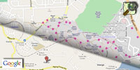
Yet despite its vast size and it being home to nearly 1 million people, Kibera did not, until recently, appear on any maps. If you peruse Google maps you'd be forgiven for thinking that the area was uninhabited. Apart from a few sparse roads and the label 'Kibera slum', there is no other indication that the slum exists.
And so in 2009 a group of young locals set about mapping their community. Using OpenStreetMap and with assistance from tech experts in Nairobi, they surveyed the slum and mapped the slum including the locations of water standpipes, shops, clinics and schools.
The Map Kibera project has proved so successful that it has now grown into a fully fledged community information scheme and is being used to put pressure on the Kenyan Government to improve the facilities and sanitation.
Read more about the project at http://mapkibera.org/.
| Comments
|
| Be the first to comment. Click on Post Reply below. |
|
|
 |
|
|
 |
 |
 |
 |
|
|


