| View previous topic :: View next topic |
| Author |
Message |
MikeB
Frequent Visitor

Joined: 20/08/2002 11:51:57
Posts: 3859
Location: Essex, UK
|
 Posted: Mon Apr 24, 2006 11:04 pm Post subject: Memory-Map Britains National Park map software review Posted: Mon Apr 24, 2006 11:04 pm Post subject: Memory-Map Britains National Park map software review |
 |
|
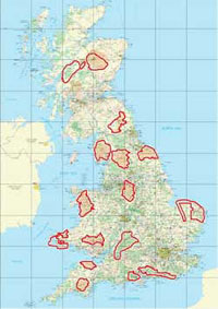
 Memory-Map have produced a special combination, of selected Ordnance Survey digital maps, the Memory-Map 5 software, and a number of predefined walking routes from Country Walking and Trail magazines. These are all packaged onto a single CD priced at £24.95 and are suitable for outdoor enthusiasts of all skills and capabilities. Memory-Map have produced a special combination, of selected Ordnance Survey digital maps, the Memory-Map 5 software, and a number of predefined walking routes from Country Walking and Trail magazines. These are all packaged onto a single CD priced at £24.95 and are suitable for outdoor enthusiasts of all skills and capabilities.
These predefined routes consist of 2 icons linked to further information. There is an "I" icon and a "R" icon. The I icons are linked to pdf files which are the magazine route cards. The R icons are linked to memory-map routes. These routes can of course be downloaded to your GPS or PDA and printed as normal.
click here to read the full review...
_________________
Mike Barrett |
|
| Back to top |
|
 |
andy7668
Occasional Visitor

Joined: Apr 26, 2006
Posts: 3
|
 Posted: Wed Apr 26, 2006 6:08 pm Post subject: Memory Map V5 Country Walking / Trail Posted: Wed Apr 26, 2006 6:08 pm Post subject: Memory Map V5 Country Walking / Trail |
 |
|
I purchased the disk at weekend and have it running on the Laptop and my Acer N35 with the GPS enabled. What a product, just need to save up and get the maps for the rest of the Country. If you only wish the coverage of the National Parks what a great buy, If you want more it is a good start, but can be expensive, but could be worth while. Got to save my pocket money  and get the maps for the rest of Great Britain. Oh Happy walking. and get the maps for the rest of Great Britain. Oh Happy walking. |
|
| Back to top |
|
 |
alanf
Occasional Visitor

Joined: Mar 13, 2006
Posts: 39
Location: NW London
|
 Posted: Fri Apr 28, 2006 9:51 am Post subject: Re: Memory Map V5 Country Walking / Trail Posted: Fri Apr 28, 2006 9:51 am Post subject: Re: Memory Map V5 Country Walking / Trail |
 |
|
| andy7668 wrote: | | I ... have it running on the Laptop and my Acer N35 with the GPS enabled. |
Sounds very useful, what does it need or integrate with on the pda? Does the map use a lot of space?
_________________
Acer n35, Destinator 3.0.75, Destinator 6 |
|
| Back to top |
|
 |
andy7668
Occasional Visitor

Joined: Apr 26, 2006
Posts: 3
|
 Posted: Wed May 03, 2006 8:53 am Post subject: Posted: Wed May 03, 2006 8:53 am Post subject: |
 |
|
To intergrate with the PDA you just need the MS syc software.
Regards the size of the maps you can download a whole map which for the national parks is approx 25 - 30 Meg or you can just download the screen size. I have also got the Northern England which is much bigger at around 630 Meg but again you can just download an area. It also allows you to download direct to the memory card via a card reader to speed the process up. Hope that answers the question about the needs and map sizes. |
|
| Back to top |
|
 |
andy7668
Occasional Visitor

Joined: Apr 26, 2006
Posts: 3
|
 Posted: Wed May 03, 2006 8:59 am Post subject: Posted: Wed May 03, 2006 8:59 am Post subject: |
 |
|
| Sorry, the software disk also has a little application on to run on the PDA which allows the map to be read and displayed. |
|
| Back to top |
|
 |
mikealder
Pocket GPS Moderator


Joined: Jan 14, 2005
Posts: 19638
Location: Blackpool , Lancs
|
 Posted: Wed May 03, 2006 9:29 am Post subject: Re: Memory Map V5 Country Walking / Trail Posted: Wed May 03, 2006 9:29 am Post subject: Re: Memory Map V5 Country Walking / Trail |
 |
|
| alanf wrote: | | Sounds very useful, what does it need or integrate with on the pda? |
Don't forget you can also run this software on a Smart Phone, limitted functionality compared to PDA - Mike |
|
| Back to top |
|
 |
|
![]() Posted: Today Post subject: Pocket GPS Advertising Posted: Today Post subject: Pocket GPS Advertising |
|
|
We see you’re using an ad-blocker. We’re fine with that and won’t stop you visiting the site.
Have you considered making a donation towards website running costs?. Or you could disable your ad-blocker for this site. We think you’ll find our adverts are not overbearing!
|
|
| Back to top |
|
 |
|