$GoogleCode
SatNav GPS
Navigate Our Site

MEMBERS AREA
Subscribe Now
Speed Camera Download
Submit Cameras
Free Competition
Member Discounts
Your Account
Member Forums

PUBLIC GPS FORUMS
Register to Post
Log in to Post
Private Messages
Your Account
Public GPS Forums

POINTS OF INTEREST
300,000+ Free POIs
Submit POIs

REVIEWS & ARTICLES
Full Listing
[+] Apple
[+] Article
There is No Silver Bullet Accurate Traffic Information Requires Multiple Data Sources : Jul08

PocketGPSWorld.com Active Speed Camera Statistics : Jul08

Pocket GPS Terminology : Dec07

Galileo European GPS Constellation Gets Go Ahead : Nov07

A Day in The Life of a PocketGPSWorld.com Verifier : Nov07

Nikon D300 and D3 GPS enabled cameras : Nov07

The Ordnance Survey have 4 million POIs : Nov07

3,2,1 Liftoff... The latest GPS Satellite is successfully launched into orbit : Oct07

Mike's Muses: Diving with GPS? : Mar07

[+] Binatone
[+] Blaupunkt
[+] Brodit
[+] Carcomm
[+] CoPilot
[+] Destinator
[+] Directions Ltd
[+] Event
[+] Evermore
[+] Fugawi
[+] Garmin
[+] Globalsat
[+] Holux
[+] Intellinav
[+] Krusell
[+] Magellan
[+] Mapopolis
Mapopolis 4.71 review : Jun06

[+] Memory-Map
[+] Mio
[+] Nav N GO
[+] Navigon
[+] Navman
[+] Navteq
[+] Other
[+] Otterbox
[+] Qstarz
[+] Route66
[+] Royaltek
[+] Satmap
[+] TomTom
Carcomm x20/x30 Cradle CNM-165 : Aug08

TomTom - How to remove cameras Tutorial : Jul08

Speed Camera Voice Alert Collections for Garmin, Route66 and TomTom : Jun08

Customise your GPS/SatNav : May08

TomTom Navigator Custom Cursors : Apr08

Speed Camera Icons by GerryC : Feb08

Speed Camera Voice Alert Collections for TomTom and Route66 : Feb08

Speed Camera Voice Alert Collections for TomTom and Route66 : Feb08

TomTom GO 920T In-Depth Review : Jan08

Pocket GPS UK Safety Camera Database - TomTom Go/Rider/One - OV2 : Jan08

PocketGPSWorld Safety Camera Database - TOMTOM GO 910, x20 and x30 : Jan08

PocketGPSWorld Speed Camera Database - TOMTOM Navigator 5 & 6 : Jan08

TomTom NavCore 7.2 Device-Dependent Feature List : Oct07

TomTom Version 7 : Mapshare Moving a POI : Jun07

TomTom Version 7 : Map Share blocking/unblocking a road : Jun07

TomTom Bluetooth Remote Control Review : Jun07

TomTom Cannes Announcement report : Jun07

Publishing real time TomTom journey information on the internet : Oct06

TomTom One New Edition second thoughts : Oct06

TomTom Compatibility matrix for program builds and map versions : Sep06

TomTom One New Edition first thoughts : Aug06

Inside the TomTom GO 910 : Jul06

TomTom RIDER Review : Jan06

TomTom ONE Review : Jan06

TomTom 510 710 910 Overview : Jan06

TomTom RIDER Scooter Install : Jan06

PocketGPSWorld.com POICapture for TomTom 5 by Lutz Bendlin : Nov05

PocketGPSWorld.com POICapture for TomTom 5 by Lutz Bendlin : Nov05

PocketGPSWorld.com POICapture for TomTom GO by Lutz Bendlin : Nov05

Glarestomper II for TomTom GO review : Oct05

TomTom MK-II Bluetooth receiver review : Oct05

TomTom MK-II Bluetooth receiver review : Oct05

[+] Trimble
[+] ViaMichelin
[+] Wonde Proud

GPS CENTRAL
About Pocket GPS
Contact Pocket GPS
Corporate Enquiries
Free GPS Downloads
GPS Events
GPS Event Blogs
GPS Related FAQs
GPS Reviews
News Archive
Report Piracy
Stolen GPS Register
Submit GPS News
Suggestion Box
Site Map

HELP
Registration Help
Subscription Help
Speed Cameras Help

SEARCH
Search GPS News
Search the GPS Forums
Google Pocket GPS Search
Pocket GPS
Web


Bookmark & Share!

Click Now to Bookmark and Share Pocket GPS! Click Now to Bookmark and Share Pocket GPS!

NAVTEQ Part 1/3 - A Visit to NAVTEQ 03rd November 2004

Article by Dave Burrows


Introduction

Many people who read PocketGPSWorld.com and take part in the forums always have questions regarding NAVTEQ and TeleAtlas data, various questions like "why roads are not appearing in the end product release of the software I purchased?". We have been talking at length with both NAVTEQ and TeleAtlas recently about these sorts of questions and how the companies collect their data and process it.


NAVTEQ recently invited the PocketGPSWorld.com Team to visit one of their data field offices based in Borehamwood. Darren, Mike and myself attended the field office and the main objectives were to see NAVTEQ at work, receive a presentation, understand how the various data is collected and mapped into layers, and to take part in a road survey where a NAVTEQ data collection team drive and map some roads.


Introduction to NAVTEQ

As most of you who actively follow GPS and Satellite Navigation will know, NAVTEQ has recently undergone a complete re-branding from it's old name Navigation Technologies (NAVTECH) to the new name NAVTEQ on March 15th 2004.


NAVTEQ was founded in 1985 in Silicon Valley, California focusing on capturing the reality of the road network, Philips Electronics signed on as an early investor and NAVTEQ grew substantially and in 1991 opened it's first European office. Today NAVTEQ has over 1,500 employee's worldwide, with 375European Field Researchers and 575 worldwide researchers in total.


NAVTEQ's headquarters are based in Chicago, USA and NAVTEQ is now one of a few major mapping companies in the world.


NAVTEQ's UK local offices are based in Edinburgh, Newry, Manchester, Leamington Spa, and Borehamwood (the latter being the field office we visited) with an administrative office in Bourne End, Bucks. The NAVTEQ UK team consists of only 28 geographic researchers.


NAVTEQ Data Releases

NAVTEQ currently offer 4 releases per year of their data to their client base. These clients include companies like BMW, Vauxhall, Ford, Alpine, Blaupunkt, Siemens VDO, Garmin, Thales, ALK, Mapopolis, Navigon and many more. NAVTEQ still operate the vision of more is better, and in a an ideal world would like to get to a closer release of every 1 or 2 months which is significantly higher than comparative mapping company releases (TeleAtlas currently offers two releases a year to it's client base).


How NAVTEQ map the streets

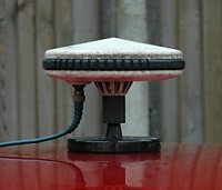
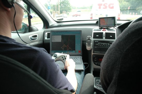
NAVTEQ researchers travel in pairs with a GPS receiver mag mounted to the roof of the car using DGPS accurate to one metre. This receiver is connected to a laptop computer using special software to help them check the accuracy of current maps or create new ones. The co-driver constantly talks to the laptop via a connected headset noting all the changes as they travel the roads.


Each researcher manages his or her own geographic area handling the entire process from start to finish. This means consistency, continuity and a quicker update process.


But why is it necessary to spend so much time on the road? Time is spent in the office researching details of road changes provided by local councils, building developers and public notices. However, all this information is field surveyed to ensure the change has definitely taken place; it has been correctly understood; and to observe it from a navigational point of view.


Back in the office, the laptop is simply plugged in and linked to the main database ready for the new information to be coded and sent back to the mainframe. Quality control is, of course, paramount and a series of on-going checks culminate in around 400 software reports which test the new data. Only at this stage is it merged with any existing data and then it is tested all over again…


PocketGPSWorld.com Mapping the Streets

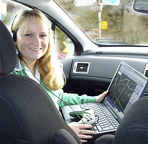
We joined a research team and drove around the roads in Borehamwood with a pre-plotted map on the laptop. The team consisted of:-

  • Driver (Graham - UK & Ireland Country Manager)
  • Co-Driver (Dan - Senior Geographic Researcher and Team Leader in the Borehamwood Office)

The co-driver (Dan) had full control of the laptop. The GPS data feed coming from the DGPS antenna fixed to the roof continued to plot our position on the map (just like it does in your regular SatNav product) but at a moments notice he could click and record an audio file.


Audio files are important and are constantly recorded along the route, contra to popular belief, NAVTEQ take no digital photos or video footage when recording the mapping data. Audio is all NAVTEQ require as it the Geographic Researcher can record every item or object he can see and supplements the recorded positional data. This includes annotations like:-

  • "POI on left - Smith's Hotel "
  • "re-categorise road" - due to speed bumps
  • "left hand turn only"
  • "speed of road 30mph"


Each road name is created as an audio file and not only spoken in full, but also spelt letter by letter to clarify the correct spelling of the road.


Dan also explained to us that mini roundabouts are not recorded as roundabouts. Any roundabout that doesn't have a suitable hard surfaced island in the centre of the roundabout is classified as a mini roundabout and will be treated as a normal junction/cross roads.


The driver although his main task is to drive the streets on the plotted course and to also receive directions from the co-driver if required, he also acts as a backup and can point out various POI's and other restrictions that are not necessarily picked up by the co-driver. All of this data is then recorded and taken back to the field office where the data is uploaded to the server so the data can be worked on.


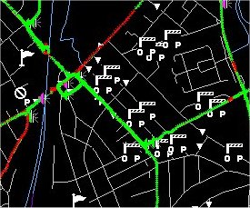
Below is a sample map which shows exactly what NAVTEQ see when they are driving the streets. You can see various POI prompts and voice annotations on the screen and all this information is recorded back to the server and kept for future use, so if anyone logs a fault on a road and send this to NAVTEQ via their fault reporting website, NAVTEQ can historically return to the data to see when it was last driven, who drove and recorded the information, right down to the annotations used. If data on the road has changed, like from a two-way system to a one-way system, NAVTEQ will clarify this with local agencies, and if needed add it to the projects list to re-drive the road to verify the data.


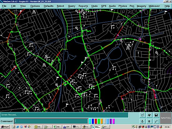
As you can see from the above screenshot, the mapping data looks very basic, and it doesn't need to be flashy at this stage of the process. Mapping an average size town can only take a couple of megabytes of data which makes data storage easy. It's only when it comes further down the chain to the GPS company who will be writing the application to manipulate NAVTEQ's data will the maps be made to look more like maps that we the consumer would like to see.


ALK - CoPilot Live | PPC 5


Navman SmartST Pro


PowerLOC Destinator


Comments
Posted by nej on Wed Nov 03, 2004 5:19 pm Reply with quote

Very interesting article - thanks Dave.


Posted by mark1968 on Wed Nov 03, 2004 6:51 pm Reply with quote

Excellent and Informative article, thank you Dave.


Regards

Mark
--------------------
Orange HTC Tytn II, 8GB Memory card, TomTom Navigator 6, Copilot 7

Current favourite (Copilot 7)

 
Posted by Leeus on Wed Nov 03, 2004 7:19 pm Reply with quote

Yeah thanks guys, good article!


Posted by Dave on Wed Nov 03, 2004 7:34 pm Reply with quote

Hopefully it's given a good insight into how NAVTEQ map the roads and what to expect from NAVTEQ in the very near future! :D


Posted by icsys on Wed Nov 03, 2004 8:12 pm Reply with quote

You should thank Navteq on our behalf for sharing their data collection process.

Now if only TeleAtlas were as accommodating for the benefit of tomTom and navman users Wink


Ian.
iPAQ 2210 (ROM 1.10.07) | Navman 4100 BT Receiver
Navman iCN 635
SmartST™ V2 and V3 EU, V3.5 UK
Anquet OS mapping
Navman POI's

 
Posted by snark on Wed Nov 03, 2004 8:20 pm Reply with quote

Another article can be found about Navtech on the PDAFrance website here. Of course it's in French but there are some nice pictures about the stuff they have in the car. So it may be interesting for you to look at, even if you don't understand French. Wink


The greatest prison is the human mind

 
Posted by snark on Wed Nov 03, 2004 8:33 pm Reply with quote

The article contains links to 2 movies. One has no speech, only music. The second one, on the other hand, has speech ... in English and is very interesting! 8)


The greatest prison is the human mind

 
Posted by Dave on Thu Nov 04, 2004 8:58 am Reply with quote

icsys Wrote:
You should thank Navteq on our behalf for sharing their data collection process.

Now if only TeleAtlas were as accommodating for the benefit of tomTom and navman users Wink

We do actually have an invite pending from TeleAtlas, but it's trying to fit it in with our busy schedules (and day jobs). It means flying over to mainland Europe as there are no real field offices here in the UK for TeleAtlas.


Posted by proctog on Fri Nov 05, 2004 11:54 am Reply with quote

Great article.

In some of the pictures, the co-driver is holding what I'm pretty sure is a Microsoft SideWinder gamepad - what do they use that for?

Glenn.


Posted by snark on Fri Nov 05, 2004 12:26 pm Reply with quote

The French article says

Quote:
Un joystick de jeu est aussi utilise afin de faire plus rapidement les modifications (tracés, sélection d’objets,…).

which means
Quote:
A joystick is also used to do some changes more quickly (layout, object selection, ...

There are no more details about it.


The greatest prison is the human mind

 
Posted by proctog on Fri Nov 05, 2004 12:39 pm Reply with quote

snark Wrote:
The French article says
Quote:
Un joystick de jeu est aussi utilise afin de faire plus rapidement les modifications (tracés, sélection d’objets,…).

which means
Quote:
A joystick is also used to do some changes more quickly (layout, object selection, ...

There are no more details about it.


Thanks. I bet that's a cover story and they just drive around playing games all day Smile

Glenn.


Click here to view more comments...
Reply to topic

Ads by Pocket GPS


#1 For GPS & PDAs
Sale! Find the latest 2008 Models in stock. Next day delivery. TomTom, HTC etc...
Handtec.co.uk/SatNav


Evermore GT-800
EverPhoto on Google Earth and Google Map for data logging and navigation
EvermoreGPS.com


TomTom Go 720
Specialists in refurbished Sat Navs incl. award winning TomTom GO720
TotalPDA.co.uk/GO 720


ProClip Car Mounts
Need a safe mount for your hand held device? Order a ProClip, clips on in seconds
ProClipUSA.com


Upgrade Garmin!
Click Here for 5 Superb Ideas for Garmin SatNavs. Free trial downloads!
Roadtour.co.uk


Advertise Here Now!
70 million totally targeted page views of your advert over a full 12 month period
PocketGPSWorld.com


Google Search

Google

Web
Pocket GPS